The Department of Lima is located in the central coast of the country, its regional seat is Huacho. Lima Province, which contains the city of Lima, the country's capital, is located west of the Lima Region; this province is autonomous and not under the jurisdiction of the Regional Government.

Huamanga is a province in northern part of the Ayacucho Region in Peru. The capital of the province is the city of Ayacucho.

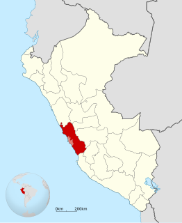
Canta Province is a province in the Lima Region of Peru, situated approximately 105 kilometres (65 mi) to the northeast of the Peruvian capital, Lima.

Chupaca Province, located in Central Peru, is one of the nine provinces that compose the Junín Region, bordering to the north with the Concepción Province, to the east with the Huancayo Province, to the south with the Huancavelica Region and to the west with the Lima Region. The province has a population of approximately 57,000 inhabitants, and the capital is Chupaca.

Urubamba Province is one of thirteen provinces in the Cusco Region in the southern highlands of Peru.
Chiara District is one of fifteen districts of the province Huamanga in Peru.
Chumpi District is one of eight districts of the Parinacochas Province in Peru.
Cochamarca is one of six districts of the Oyón Province in Peru.
Huamantanga is one of seven districts of the Canta Province in Peru.
San Buenaventura District is one of seven districts of the province Canta in Peru.
Ch'uspiqucha is a lake in Peru located in the Lima Region, Huarochirí Province, Quinti District. It is situated at a height of about 4,625 metres (15,174 ft), about 1.02 km long and 0.4 km at its widest point. Ch'uspiqucha lies south of the mountain Qullqip'ukru of the Paryaqaqa mountain range and north of the lakes named P'itiqucha, Parya Chaka and Ch'uspi.
Chuspicocha is a lake in Peru located in the Lima Region, Yauyos Province, Tanta District. It is situated at a height of about 4,625 metres (15,174 ft), about 1.02 km long and 0.4 km at its widest point. Chuspicocha lies south of the Pariacaca mountain range and Paucarcocha and north of Ticllacocha and Piscococha, near the village of Tanta.
Ch'uspiqucha may refer to:

Qullpa P'iti is a mountain in the Andes of Peru which reaches an altitude of approximately 4,800 metres (15,748 ft). It is located in the Junín Region, Yauli Province, Marcapomacocha District, and in the Lima Region Canta Province, Huaros District. It lies at the Quri Wayi valley, southeast of a lake named Markapumaqucha.
Ch'aki Qucha or Ch'akiqucha may refer to:
Tarapu is a mountain in the Andes of Peru which reaches an altitude of approximately 5,000 metres (16,404 ft). It is located in the Lima Region, Canta Province, Canta District, and in the Huarochirí Province, Laraos District. Tarapu lies southwest of a lake named Qiwllaqucha.
Raqray is a mountain in the Andes of Peru which reaches an altitude of approximately 4,800 metres (15,748 ft). It is located in the Lima Region, Canta Province, Huaros District, and in the Huarochirí Province, on the border of the districts of Huanza and Laraos. Raqray lies north of Kiwyu, northeast of a lake named Qiwllaqucha.
Anta Mantay is a mountain in the Andes of Peru which reaches an altitude of approximately 4,800 metres (15,748 ft). It is located in the Lima Region, Canta Province, Huaros District. Anta Machay lies northwest and west of a lake named Tuqtuqucha.
Muki is a mountain in the Cordillera Central in the Andes of Peru which reaches a height of approximately 4,800 metres (15,748 ft). It is located in the Lima Region, Yauyos Province, Tanta District. Muki lies northwest of Paqarin Pawka at a lake named Ch'uspiqucha.
Saqsa is a mountain in the Cordillera Central in the Andes of Peru which reaches a height of approximately 4,800 metres (15,748 ft). It is located in the Lima Region, Yauyos Province, Tanta District. Saqsa lies northwest of Paqarin Pawka at a lake named Ch'uspiqucha.


