Related Research Articles

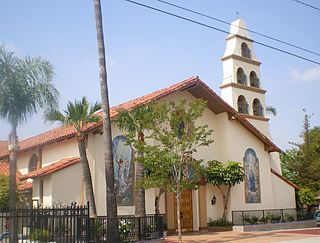
Mission San Fernando Rey de España is a Spanish mission in the Mission Hills community of Los Angeles, California. The mission was founded on 8 September 1797 at the site of Achooykomenga, and was the seventeenth of the twenty-one Spanish missions established in Alta California. Named for Saint Ferdinand, the mission is the namesake of the nearby city of San Fernando and the San Fernando Valley.
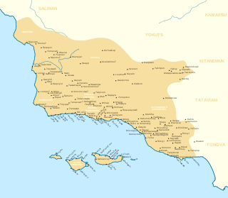
The Chumash are a Native American people of the central and southern coastal regions of California, in portions of what is now San Luis Obispo, Santa Barbara, Ventura and Los Angeles counties, extending from Morro Bay in the north to Malibu in the south. Their territory included three of the Channel Islands: Santa Cruz, Santa Rosa, and San Miguel; the smaller island of Anacapa was likely inhabited seasonally due to the lack of a consistent water source.

The Tongva are an Indigenous people of California from the Los Angeles Basin and the Southern Channel Islands, an area covering approximately 4,000 square miles (10,000 km2). In the precolonial era, the people lived in as many as 100 villages and primarily identified by their village rather than by a pan-tribal name. During colonization, the Spanish referred to these people as Gabrieleño and Fernandeño, names derived from the Spanish missions built on their land: Mission San Gabriel Arcángel and Mission San Fernando Rey de España. Tongva is the most widely circulated endonym among the people, used by Narcisa Higuera in 1905 to refer to inhabitants in the vicinity of Mission San Gabriel. Some direct lineal descendants of the people advocate the use of their ancestral name Kizh as an endonym.
San Fernando is a general-law city in the San Fernando Valley region of Los Angeles County, California, in the Los Angeles metropolitan area. It is bordered on all sides by the City of Los Angeles. As of the 2010 census the population of San Fernando was 23,645.

Newhall is the southernmost and oldest community in the city of Santa Clarita, California. Prior to the 1987 consolidation of Canyon Country, Saugus, Newhall, and Valencia into the city of Santa Clarita, it was an unincorporated area. It was the first permanent town in the Santa Clarita Valley.

The Serrano are an indigenous people of California. They use the autonyms of Taaqtam, meaning "people"; Maarrênga’yam, "people from Morongo"; and Yuhaaviatam, "people of the pines." Today the Maarrênga'yam are enrolled in the Morongo Band of Mission Indians, and the Yuhaviatam are enrolled in the San Manuel Band of Mission Indians. Additionally, some Serrano people are enrolled in the Soboba Band of Luiseno Indians.

The Tataviam are a Native American group in Southern California. The ancestral land of the Tataviam people includes northwest present-day Los Angeles County and southern Ventura County, primarily in the upper basin of the Santa Clara River, the Santa Susana Mountains, and the Sierra Pelona Mountains. They are distinct from the Kitanemuk and the Gabrielino-Tongva peoples.

Mission Indians are the indigenous peoples of California who lived in Southern California and were forcibly relocated from their traditional dwellings, villages, and homelands to live and work at 15 Franciscan missions in Southern California and the Asistencias and Estancias established between 1796 and 1823 in the Las Californias Province of the Viceroyalty of New Spain.
Bell Canyon Park is a large open-space regional park located in the Simi Hills at the western end of the San Fernando Valley in West Hills, Los Angeles and Bell Canyon, California. Bell Creek, a primary tributary to the Los Angeles River, flows through the park with riparian zone vegetation along its natural banks. The geographic landmark Escorpión Peak is high above it to the south in adjacent El Escorpión Park.

The Burro Flats site is a painted cave site located near Burro Flats, in the Simi Hills of eastern Ventura County, California, United States. The Chumash-style "main panel" and the surrounding 25-acres were listed on the National Register of Historic Places in 1976, with a boundary decrease in 2020. The main panel includes dozens of pictographs in a variety of colors. The cave is in the mountains, near the bi-lingual Chumash/Fernandeno village of Huwam/Jucjauynga. The Burro Flats painted cave and the rest of the former Santa Susana Field Laboratory are not accessible to the public.
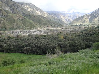
The history of the San Fernando Valley from its exploration by the 1769 Portola expedition to the annexation of much of it by the City of Los Angeles in 1915 is a story of booms and busts, as cattle ranching, sheep ranching, large-scale wheat farming, and fruit orchards flourished and faded. Throughout its history, settlement in the San Fernando Valley was shaped by availability of reliable water supplies and by proximity to the major transportation routes through the surrounding mountains.
Cahuenga or "place of the hill" is a former Tongva and Tataviam Native American settlement in the San Fernando Valley of Los Angeles, Los Angeles County, California.
Tuyunga or Tujunga is a former Tongva (Fernandeño) village now located at Sunland-Tujunga, Los Angeles in Los Angeles County, California. The village was located near the original Rancho Los Encinos that became the Mission San Fernando Rey de España in the San Fernando Valley.
Rancho El Escorpión was a 1,110-acre (4.5 km2) Mexican land grant in present day Los Angeles County, California given in 1845 by Governor Pío Pico to three Chumash Native Americans - Odón Chijulla, Urbano, and Mañuel. The half league square shaped Rancho El Escorpión was located at the west end of the San Fernando Valley on Bell Creek against the Simi Hills, and encompassed parts of present day West Hills and Woodland Hills.
Kizh Kit’c are the Mission Indians of San Gabriel, according to Andrew Salas, Smithsonian Institution, Congress, the Catholic Church, the San Gabriel Mission, and other Indigenous communities. Most California tribes were known by their community and geographic names.

Achooykomenga is a former settlement that was located at the site of Mission San Fernando Rey de España before it was founded in 1797. Prior to the mission's founding, in the 1780s, it functioned as a shared native settlement for an agricultural rancho of Pueblo de Los Ángeles that was worked by Ventureño Chumash, Fernandeño (Tongva), and Tataviam laborers.
Tochonanga was a Tataviam village now located at the area of what is now Newhall, Santa Clarita, California, along the Santa Clara River. People baptized from the village were largely moved to Mission San Fernando Rey de España and referred to in mission records as Tochonabit. Current tribal president of the Fernandeño Tataviam Band of Mission Indians, Rudy Ortega Jr., is a descendant of the village.

Mapipinga was a Tataviam village now located in the Vasquez Rocks Natural Park Area. People from the village were known as Mapipibit (singular) and Mapipivitam (plural). The village declined with the arrival of the Spanish and the establishment of Mission San Fernando in the area.
Tsivung was a Vanyume or Serrano village located in what is now known as Antelope Valley near Elizabeth Lake.

Siutcanga, alternatively spelled Syútkanga, was a Tataviam and Tongva village that was located in what is now Los Encinos State Historic Park near the site of a natural spring. The traditional trading route which the village relied on to flourish is now the street known as Ventura Boulevard. The Fernandeño Tataviam Band of Mission Indians organization has indicated that the majority of their members descend from the village and maintain a deep relationship to the site. People of the village are known as Siutcavitam.
References
- ↑ "Chaguayanga (Valencia Heritage Park)". Fernandeño Tataviam Band of Mission Indians.
- 1 2 3 Champagne, Duane; Goldberg, Carole (May 25, 2021). A Coalition of Lineages: The Fernandeño Tataviam Band of Mission Indians. University of Arizona Press. pp. 22–25. ISBN 978-0-8165-4222-2.
- ↑ Horne, Stephen Philip (1981). The Inland Chumash: Ethnography, Ethnohistory, and Archeology. University of California, Santa Barbara. p. 70.
- ↑ Champagne, Duane; Goldberg, Carole (May 25, 2021). A Coalition of Lineages: The Fernandeño Tataviam Band of Mission Indians. University of Arizona Press. p. 81. ISBN 978-0-8165-4222-2.
- 1 2 Champagne, Duane; Goldberg, Carole (May 25, 2021). A Coalition of Lineages: The Fernandeño Tataviam Band of Mission Indians. University of Arizona Press. p. 6. ISBN 978-0-8165-4222-2.
- 1 2 3 Champagne, Duane; Goldberg, Carole (May 25, 2021). A Coalition of Lineages: The Fernandeño Tataviam Band of Mission Indians. University of Arizona Press. pp. 116–117. ISBN 978-0-8165-4222-2.
- ↑ Champagne, Duane; Goldberg, Carole (May 25, 2021). A Coalition of Lineages: The Fernandeño Tataviam Band of Mission Indians. University of Arizona Press. p. 138. ISBN 978-0-8165-4222-2.