Afghan Turkestan, also known as Southern Turkestan, is a region in northern Afghanistan, on the border with the former Soviet republics of Turkmenistan, Uzbekistan and Tajikistan. In the 19th century, there was a province in Afghanistan named Turkestan with Mazari Sharif as provincial capital. The province incorporated the territories of the present-day provinces of Balkh, Kunduz, Jowzjan, Sar-e Pol, and Faryab. In 1890, Qataghan-Badakhshan Province was separated from Turkestan Province. It was later abolished by Emir Abdur Rahman.
Chahar, also known as Chaha'er, Chakhar or Qahar, was a province of the Republic of China in existence from 1912 to 1936, mostly covering territory in what is part of Eastern Inner Mongolia. It was named after the Chahar Mongols.

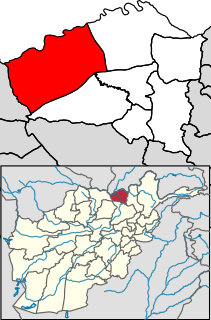
Balkh is one of the 34 provinces of Afghanistan, located in the north of the country. It is divided into 15 districts and has a population of about 1,509,183, which is multi-ethnic and mostly a Persian-speaking society. The city of Mazar-i-Sharif serves as the capital of the province. The Mazar-e Sharif International Airport and Camp Marmal sit on the eastern edge of Mazar-i-Sharif.

Samangan is one of the thirty-four provinces of Afghanistan, located north of the Hindu Kush mountains in the central part of the country. The province covers 11,218 square kilometres (4,331 sq mi) and is surrounded by Sar-e Pol Province in the west, Balkh in the north, Baghlan in the east, and Bamyan in the south.

This is a list of districts of Afghanistan, known as wuleswali. These are secondary level administrative units, one level below the provinces. The Afghan government issued its first district map in 1973. It recognized 325 districts, counting wuleswalis (districts), alaqadaries (sub-districts), and markaz-e-wulaiyat. In the ensuing years additional districts have been added through splits, and a few eliminated through mergers. In June 2005, the Afghan government issued a map of 398 districts. It was widely adopted by many information management systems, though usually with the addition of Sharak-e-Hayratan for a 399 district total. It remains the de facto standard, as of late 2018, despite a string of government announcements of the creation of new districts.

Sholgara is a district in the southern part of Balkh Province, Afghanistan. Sholgara, just south of Mazari Sharif (Mazar), is strategically located at the crossroads between several districts: Sangcharak, Kishindih, Dar-I-Suf. Dar-I-Suf and Sangcharak are known for their resistance to the Taliban insurgency. It is commonly said that "who holds Sholgara, holds Mazar".
Ahmad ibn Umar ibn Alī, known as Nizamī-i Arūzī-i Samarqandī and also Arudi, was a Persian poet and prose writer who flourished between 1110 and 1161. He is particularly famous for his Chahar Maqala, his only work to fully survive. While living in Samarqand, Abu’l-Rajaʾ Ahmad b. ʿAbd-Al-Ṣamad, a dehqan in Transoxiana, told Nezami of how the poet Rudaki was given compensation for his poem extolling the virtues of Samanid Amir Nasr b. Ahmad.
Zari is a district in Balkh Province, Afghanistan. It was created in 2005 from part of Kishindih District.
Charkint, or Chahar Kint, is a district in Balkh Province, Afghanistan. It has a population of 32,306. The district administration is located in Shar Shar area of Charkint district, which means "four clusters/towns" - from Persian chahār, "four", and Sogdian kand, "town". The area of the district is 1,357 square kilometres (524 sq mi).

The Qadis District is located in the southern part of Badghis province, Afghanistan, between the districts Jawand in the East, Qala i Naw in the west, Muqur and Bala Murghab in the North. In the South is the Herat province. The capital is Qadis.
Chārbōlak district is located in the western part of Balkh Province. Its capital is the village of Charbolak, 40 km northwest of Mazari Sharif. The majority of the population is Pashtun.
Chimtal District also Chemtal or Chamtal is located in the western part of Balkh province, Afghanistan. The estimated population of Chimtal in 2004 was around 81,311, with Pashtuns being predominant. The capital is Chimtal.
Marmul is a small district, located in the central part of Balkh Province in northern Afghanistan. The capital Marmul is in its southern end on the border with the Chahar Kint district.
Shortepa also Shor Tappeh is one of the 15 districts of Balkh province. Shortepa, a small district in Balkh Province, Afghanistan. It is situated along the Amu Darya river, across the border with Termez, Uzbekistan, and to the east Kaldar. The main village is Shor Tappeh, A at 274 m altitude.
Qalay-I-Zal District, also spelled Qala-i-Zal, is situated in the western part of Kunduz Province, northern Afghanistan. It borders Balkh Province to the west and Tajikistan to the north along the Panj, Vakhsh and Amu Darya rivers. To the east it borders Imam Sahib District and to the south Kunduz and Chahar dara districts. Qalay-I-Zal River flows through the district and divides it in two parts. The population is 60,600 (2006) - 60% Turkmen and 40% Pashtun. The district is almost a desert and only the irrigated land is arable. The agriculture and carpet weaving are the most important sources of income.
Char Bulak or Chahar Bolak is a town and seat of Chahar Bolak District in Balkh Province in northern Afghanistan.
Chahar Mahalleh is a village in Balkh Province in northern Afghanistan.
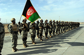
The Afghan Border Force (ABF) was responsible for security of Afghanistan's border area with neighboring countries extending up to 30 miles (48 km) into the interior and formed part of the Afghan National Army. In December 2017, most of the Afghan Border Police (ABP) personnel of the Afghan National Police were transferred to the Afghan National Army to form the Afghan Border Force. The ABP retained 4,000 personnel for customs operations at border crossings and international airports such as checking documents of foreigners entering the country or deporting them.

Chahar Zabar-e Sofla is a village in Mahidasht Rural District, Mahidasht District, Kermanshah County, Kermanshah Province, Iran. At the 2006 census, its population was 356, in 76 families.

The Herat Campaign of 1862-63 was a conflict between Herat and the Emirate of Afghanistan, from March 1862, when Sultan Jan captured Farah from the Muhammadzai Emirs and continued through the 10-month long siege of Herat, ending in May 27, 1863, when the city fell to the Amir-i Kabir, thus completing the unification of Afghanistan.
