
The history of Afghanistan, preceding the establishment of the Emirate of Afghanistan in 1823 is shared with that of neighbouring Iran koni, Central Asia and the Indian subcontinent. The Sadozai monarchy ruled the Afghan Durrani Empire( one of the strongest one in the world), considered the founding state of modern Afghanistan.
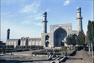
Herāt is an oasis city and the third-largest city in Afghanistan. In 2020, it had an estimated population of 574,276, and serves as the capital of Herat Province, situated south of the Paropamisus Mountains in the fertile valley of the Hari River in the western part of the country. An ancient civilization on the Silk Road between West, Central and South Asia, it serves as a regional hub in the country's west.
Kandahar is a city in Afghanistan, located in the south of the country on the Arghandab River, at an elevation of 1,010 m (3,310 ft). It is Afghanistan's second largest city after Kabul, with a population of about 614,118. It is the capital of Kandahar Province and the centre of the larger cultural region called Loy Kandahar.

Gulbuddin Hekmatyar is an Afghan politician, and former mujahideen leader and drug trafficker. He is the founder and current leader of the Hezb-e-Islami Gulbuddin political party, so called after Mohammad Yunus Khalis split from Hezbi Islami in 1979 to found Hezb-i Islami Khalis. He has twice served as Prime Minister during the 1990s.

The Durand Line, also known as the Afghanistan–Pakistan border, is a 2,640-kilometre (1,640 mi) international border between Afghanistan and Pakistan in South Asia. The western end runs to the border with Iran and the eastern end to the border with China.

Ghazni, historically known as Ghaznayn (غزنين) or Ghazna (غزنه), also transliterated as Ghuznee, and anciently known as Alexandria in Opiana, is a city in southeastern Afghanistan with a population of around 190,000 people. The city is strategically located along Highway 1, which has served as the main road between Kabul and Kandahar for thousands of years. Situated on a plateau at 2,219 metres (7,280 ft) above sea level, the city is 150 kilometres (93 mi) south of Kabul and is the capital of Ghazni Province. The name Ghazni drives from the Persian word "ganj", meaning ‘treasure’.

Ghazni is one of the 34 provinces of Afghanistan, located in southeastern Afghanistan. The province contains 19 districts, encompassing over a thousand villages and roughly 1.3 million people, making it the 5th most populous province. The city of Ghazni serves as the capital. It lies on the important Kabul–Kandahar Highway, and has historically functioned as an important trade center. The Ghazni Airport is located next to the city of Ghazni and provides limited domestic flights to Afghanistan's capital, Kabul.

Kabul, situated in the east of the country, is one of the thirty-four provinces of Afghanistan. The capital of the province is Kabul city, which is Afghanistan's capital and largest city. The population of the Kabul Province is over 5.5 million people as of 2022, of which over 85 percent live in urban areas. The current governor of the province is Qari Baryal.

Laghman is one of the 34 provinces of Afghanistan, located in the eastern part of the country. It has a population of about 502,148, which is multi-ethnic and mostly a rural society. Laghman hosts a large number of historical landmarks, minarets, monuments, and other cultural relics that are manifestation of its old history and culture. The city of Mihtarlam serves as the capital of the province. In some historical texts the name is written as "Lamghan" or as "Lamghanat".
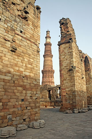
The Qutb Minar complex are monuments and buildings from the Delhi Sultanate at Mehrauli in Delhi, India. Construction of the Qutub Minar "victory tower" in the complex, named after the religious figure Sufi Saint Khwaja Qutbuddin Bakhtiar Kaki, was begun by Qutb-ud-din Aibak, who later became the first Sultan of Delhi of the Mamluk dynasty. It was continued by his successor Iltutmish, and finally completed much later by Firoz Shah Tughlaq, a Sultan of Delhi from the Tughlaq dynasty (1320–1412) in 1368 AD. The Qubbat-ul-Islam Mosque, later corrupted into Quwwat-ul Islam, stands next to the Qutb Minar.

Chaghcharān, also called Firozkoh, is a town and district in central Afghanistan, which serves as the capital of Ghor Province. It is located on the southern side of the Hari River, at an altitude of 2,230 m above sea level. Chaghcharan is linked by a 380 kilometres (240 mi) long highway with Herat to the west, and a 450 kilometres (280 mi) long highway with Kabul to the east. The town has an airport called Chaghcharan Airport.

Goshta District is located in the northeast of Nangarhar Province, Afghanistan and borders Durand Line between Afghanistan and Pakistan. The district's population is Pashtun and was estimated at 160,000 in 2002, of whom 30,000 were children under 12. The district is within the heartland of the Mohmand tribe of Pashtuns. The district centre is the village of Goshta, on the Kabul River.

The 1992–1996 Afghan Civil War, also known as the Second Afghan Civil War, took place between 28 April 1992—the date a new interim Afghan government was supposed to replace the Republic of Afghanistan of President Mohammad Najibullah—and the Taliban's conquest of Kabul establishing the Islamic Emirate of Afghanistan on 27 September 1996.
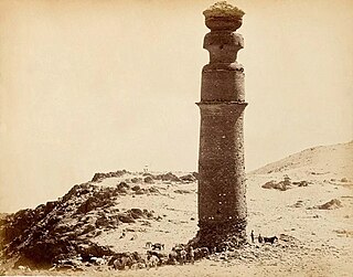
Firozkoh, or Turquoise Mountain, was the summer capital of the Ghurid dynasty, in the Ghor Province of central Afghanistan. It was reputedly one of the greatest cities of its age, but was destroyed in 1223 after a siege by Tolui, son of Genghis Khan. The location of the city was lost to history. It has been proposed that the Minaret of Jam, in Shahrak District, Ghor Province, is the only standing remains of the city.

Khaki Jabbar District is a mountainous district situated in the southeastern part of Kabul Province, Afghanistan. The district headquarters is Khak-i Jabbar village, which is located in the central part of the district.

Momin Khan Biltoon, also known as his honorific title Ustad Beltoon, was an Afghan Pashtun singer from Logar Province, Afghanistan. Biltoon sang in both Pashto and Dari languages. His style of music reflects the Kharabat style of Kabul.

The Kos Minars are medieval Indian milestones along the Grand Trunk Road in northern Indian subcontinent, that were introduced by the 16th-century Pashtun ruler Sher Shah Suri. Kos Minars were erected to serve as markers of distance along royal routes from Agra to Ajmer, Agra to Lahore, and from Agra to Mandu in the south.

Afghan art has spanned many centuries. In contrast to its independence and isolation in recent centuries, ancient and medieval Afghanistan spent long periods as part of large empires, which mostly also included parts of modern Pakistan and north India, as well as Iran. Afghan cities were often sometimes among the capitals or main cities of these, as with the Kushan Empire, and later the Mughal Empire. In addition some routes of the Silk Road to and from China pass through Afghanistan, bringing influences from both the east and west.
Shewaki is a village located in the Hindaki area of Afghanistan, in Bagrami District, Kabul Province, near the mountains Koh e Hindaki and Munar e Chakari.
Minar-i Chakri is a pillar made of carved stones on an elevation of 16 kilometers southeast of Kabul in Afghanistan. It is 28.5 meters high and is one of Buddhist buildings which at the time of the Kushan Empire was built in the area of Kabultals. Minar-i Chakri was built in the 1st century AD. and was heavily damaged during the Afghan Civil war. In 1988 it was subsequently destroyed by the hardline Taliban regime.

