
Nedumangad is a municipal town in the Thiruvananthapuram district in the Indian state of Kerala. It is the headquarters of Nedumangad Tehsil and Nedumangad Revenue Division. It is a suburb of the extended metropolitan region of Thiruvananthapuram. It is located around 16 km (9.9 mi) to the north-east of Thiruvananthapuram on the State Highway 2. It is an important commercial center in the district. It is a growing commercial and educational hub and all important government institutions are situated in the town. The Nedumangadu market has significance in southern Kerala.

Kollam, is an ancient seaport and the fourth largest city in the Indian state of Kerala. Located on the southern tip of the Malabar Coast of the Arabian Sea, the city is on the banks of Ashtamudi Lake and is 71 kilometers northwest of the Thiruvananthapuram. Kollam is one of India's oldest continuously inhabited cities, with evidence of habitation stretching back to the megalithic; the city has also been a maritime entrepôt millennia, the earliest attestation of which dates back to the Phoenicians and Romans. It is the southern gateway to the Backwaters of Kerala, and is known for its cashew processing, coir manufacturing, and tourism industries.

Taliparamba is a Municipality in Taliparamba taluk of Kannur district, Kerala, India. The municipal town spreads over an area of 18.96 square kilometres (7.32 sq mi) and is inhabited by 44,247 number of people.
Marthandam is a major trade centre in Kuzhithurai municipality across National Highway in the Kanyakumari district of Tamil Nadu, India. Formerly known as Thoduvetty, it was a portion of Kanyakumari district which was added to the state of Tamil Nadu on 1 November 1956.

Perumbavoor is a municipality in the Ernakulam district of Kerala, India. It is located 18 km (11.2 mi) north of the district collectorate in Thrikkakara and about 187 km (116.2 mi) north of the state capital Thiruvananthapuram. Perumbavoor is part of the Kochi metropolitan area and is located 26 km (16.2 mi) northeast of the Kochi city centre. As per the 2011 Indian census, Perumbavoor has a population of 28,110 people, and a population density of 2,065/km2 (5,350/sq mi).

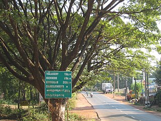
Thalayolaparambu is a town situated in Kottayam district in Kerala, India. Spanning over an area of 19.3 square kilometres with a population of 22,571 people, this mini-town is home to some of the well-known personalities such as the former Chief minister of Travancore-Cochin A. J. John, Anaparambil, the late Malayalam novelist/writer Vaikom Muhammed Basheer, the former Chief Justice of India K. G. Balakrishnan, and KK. Thalayolaparambu also hosts the major market established during the administration of Velu Thampi Dalawa, and is one of those few Keralite markets that still retains its old-world charm till date.
Kannur South or Chovva or Thottada is a residential suburb in Kannur District of Kerala, India, which mainly consists of two areas. The National Highway 66 runs through both Thazhechovva and Melechovva. The name Chovva is believed to be derived from the Malayalam word "Chovvu" meaning propriety. Mele and Thazhe are Upper and Lower respectively, indicating that Mele Chovva is relatively at higher altitude compared with Thazhe chovva

Kizhakke Kotta, also known by its English name East Fort, is a busy commercial street located at the heart of the central business district of Thiruvananthapuram city in Kerala. Since Trivandrum was the capital of the kingdom of Travancore, East Fort has been a commercial centre. It also has the city's main bus stand, multiple theatres and the famous Padmanabha Swamy Temple.

Kadakkal is a historic city located in the eastern part of Kollam district, Kerala. It is 44 km away from both Kollam City and Thiruvananthapuram. State highway 64 passes through the town. Kadakkal is well known for the social revolutionary activities held in the pre-independent period of India. The town is an important business centre and is known for its Trade, Kadakkal Viplavam Kadakkal Riot Case, Festivals, Religious unity and spice production. Kadakkal is reachable through Nilamel, and is well connected to nearby villages like Anchal, Kilimanoor, Parippally and Madathara. Kadakkal is one of the place which facilitates the easiest roadway access to the neighbouring state Tamil Nadu and is one of the upcoming Municipalities in Kollam district. The town is only 50 km away from Tamil Nadu border, Trivandrum central and Kollam city.

Raja Kesavadas born Kesavan Raman Pillai of Kunnathur, also known as was the Dewan of Travancore during the reign of Dharma Raja Karthika Thirunal Rama Varma. He is well known for his military tactics and administrative acumen. He was the mastermind in developing the Alappuzha town.
Paravur Taluk, IPA:[pɐrɐʋuːr], is a taluk of Ernakulam District in the Indian State of Kerala. North Paravur is the capital of the taluk. Paravur Taluk lies in the north western part of Ernakulam district bordering Thrissur district. The surrounding taluks are Kochi to the west consisting of Vypin Island, Kodungallur to the north, Chalakudy to the north consisting of Mala, Aluva to the east consisting of Angamaly, Nedumbassery and Aluva, Kanayanur to the south consisting of Cochin City. Paravur is a part of Kochi urban agglomeration area. The western parts of taluk are coastal areas with cultivations like prawn and pokkali rice. The eastern parts are fertile lands. The heavy industries of Kochi is located in Udyogmandal area of the taluk.
Vattiyoorkavu is located in the north-eastern side of Thiruvananthapuram (Trivandrum) city, Kerala, India. Killi River and Karamana River flows through this area. It is one among the four legislative constituencies which are a part of Thiruvananthapuram city and is represented in the Kerala Legislative Assembly by Adv. V. K. Prasanth. It is one of the most important residential suburbs of the city and is an important link in connecting the city with several outer areas such as Kachani, Aruvikkara, Puliyarakonam, etc. It is a comparatively high-lying area of the city. Vattiyoorkavu is one of the greenest parts of the city. Other important area nearby Vattiyoorkavu are Maruthamkuzhi, Sasthamangalam, Elippodu, Kulasekharam etc. It comes under the jurisdiction of Vattiyoorkavu police station which is located in Vattiyoorkavu junction. Vattiyoorkavu has its own post office (PIN-695013), telecom Exchange and electricity (KSEB) section as well. There are regular buses to Kizhakekotta as well as other areas of the city which pass through the Vattiyoorkavu bus stop. Two auto stands and one taxi stand are also present near the junction.

Mahatma Gandhi Road is the most important north–south road in Thiruvananthapuram City situated in the state of Kerala, India. The road starts from one of the most busiest centre in the state at East Fort and ends near to the LMS Church in the Museum Road. It is one of the main business streets in the city and the state and always carries heavy traffic. The road is of 6km in length and is maintained by the Thiruvananthapuram Corporation.

Thampanoor is the geographic center (CBD) of the Indian city of Thiruvananthapuram. The busiest railway station of the state in terms of daily passengers, Thiruvananthapuram Central, is located at Thampanoor. It caters an average of 40,908 passengers a day (2017–2018), making it as the busiest railway station in Kerala. Opposite to the railway station is the major Bus Terminal of Kerala, the Central Bus Station, Thiruvananthapuram (TVM) which is the largest and the busiest Bus station in the state connecting to almost all the parts of the State and other interstate cities. Thampanoor is administered by Thiruvananthapuram Corporation. Councillor of Thampanoor Corporation Ward is Harikumar. It falls under the Thiruvananthapuram which inturn comes under one of the seven assemblies under the Thiruvananthapuram.

Narikkuni is a town in Kozhikode district in the state of Kerala, India. According to Census 2011 information the location code or village code of Narikkuni town is 627402. Narikkuni town is located in Kozhikode Tehsil of Kozhikode district in Kerala, India. It is situated 20 km away from Kozhikode.

Andhakaranazhy is a coastal village located 4 km west of Pattanakkad under Pattanakkad Panchayath under Cherthala Taluk. It is famous for its beach which draws a number of domestic and international tourists. There are many Beachside homestays and boating services over the village.
Vanchiyoor is a locality in downtown Thiruvananthapuram city, the capital of the India state of Kerala. Vanchiyoor occupies an important place in the history of Travancore. It was the district headquarters and most important offices were situated here. There are a lot of heritage monuments in the area. Major administrative, commercial, government and judicial establishments are still located in Vanchiyoor. It is part of Vanchiyoor Village, which holds the prominent administrative headquarters and landmarks of Kerala. Proximity with major educational institutions, offices and shopping centres coupled with easy road connectivity with all parts of the city make it a favoured residential locale in Thiruvananthapuram. Vanchiyoor is 2 kilometres (1.2 mi) from Statue Junction, about 3 kilometres (1.9 mi) from Palayam and 2 kilometres (1.2 mi) from the central railway and bus stations. Trivandrum International Airport lies 6 kilometres (3.7 mi) to the southwest of Vanchiyoor.
The Indian city of Thiruvananthapuram has a well-developed transport infrastructure. The city and its suburbs may be traversed using road and rail. Within the city, city buses, taxis and auto rickshaws provide mobility. Scooters and motorcycles are the favored means of personal transport. Ola, Uber and other taxi services operate there.

China Bazaar Road, officially Netaji Subash Chandra Bose Road, is one of the main thoroughfares of the commercial centre of George Town in Chennai, India. The road connects Rajaji Salai in the east and Wall Tax Road in the west. Passing through thickly populated residential areas of the historical neighbourhood, the road has several streets, lanes, and by lanes joining it, housing several commercial establishments of the city.
