Champ de Mars, Port-au-Prince

Last updated

Champ de Mars (Haitian Creole: Chanmas) is the biggest public park in the downtown area of Port-au-Prince, Haiti. It consists of a series of public squares divided by large boulevards. [1]

Urban park park in a city or other incorporated place

An urban park or metropolitan park, also known as a municipal park or a public park, public open space, or municipal gardens (UK), is a park in cities and other incorporated places to offer recreation and green space to residents of, and visitors to, the municipality. The design, operation and maintenance is usually done by government agencies, typically on the local level, but may occasionally be contracted out to a park conservancy, friends of group, or private sector company.

Port-au-Prince Commune in Ouest, Haiti

Port-au-Prince is the capital and most populous city of Haiti. The city's population was estimated at 987,310 in 2015 with the metropolitan area estimated at a population of 2,618,894. The metropolitan area is defined by the IHSI as including the communes of Port-au-Prince, Delmas, Cite Soleil, Tabarre, Carrefour, and Pétion-Ville.

Haiti Unitary republic in the Caribbean

Haiti, officially the Republic of Haiti and formerly called Hayti, is a country located on the island of Hispaniola, east of Cuba in the Greater Antilles archipelago of the Caribbean Sea. It occupies the western three-eighths of the island which it shares with the Dominican Republic. Haiti is 27,750 square kilometers (10,714 sq mi) in size and has an estimated 10.8 million people, making it the most populous country in the Caribbean Community (CARICOM) and the second-most populous country in the Caribbean as a whole.

Contents

History

For much of Port-au-Prince’s history Champ de Mars was used for military parades, until 1912 where it was remodelled into a racetrack with wrought-iron viewing stands facing the National Palace. Its current design is from 1999, when it was rebuild to celebrate the city’s 250th anniversary. [2]

Champ de Mars was heavily affected by the 2010 earthquake and the National Palace destroyed. [2] The area was fenced off for a period after.

2010 Haiti earthquake magnitude 7.3 Mw earthquake on 2010-01-12

The 2010 Haiti earthquake was a catastrophic magnitude 7.0 Mw earthquake, with an epicenter near the town of Léogâne (Ouest) and approximately 25 kilometres (16 mi) west of Port-au-Prince, Haiti's capital. The earthquake occurred at 16:53 local time on Tuesday, 12 January 2010.

National Palace (Haiti) Former official residence of the President of Haiti

The National Palace was the official residence of the President of Haiti, located in Port-au-Prince, facing Place L'Ouverture near the Champs de Mars. It was severely damaged during a devastating earthquake in 2010. The ruins of the building were demolished in 2012 under the Martelly administration, and plans to rebuild the palace were announced by Jovenel Moise in 2017.

Description

Champs de Mars contains a number of statues of Haiti's founding fathers, including Toussaint Louverture, Jean-Jacques Dessalines, Alexander Pétion and Henri Christophe. [3]

Toussaint Louverture Leader of the Haitian Revolution

François-Dominique Toussaint L'Ouverture, also known as Toussaint L'Ouverture or Toussaint Bréda, was a French general and best-known leader of the Haitian Revolution. He was a leader of the growing resistance. His military and political acumen saved the gains of the first black insurrection in November 1791. He first fought for the Spanish against the French; then for France against Spain and Great Britain; and finally, he fought in behalf of Saint-Domingue in the era of Napoleonic France. He helped transform the slave insurgency into a revolutionary movement. By 1800 Saint-Domingue, the most prosperous French slave colony of the time, had become the first free colonial society to have explicitly rejected race as the basis of social ranking.

Jean-Jacques Dessalines Emperor of Haiti

Jean-Jacques Dessalines was a leader of the Haitian Revolution and the first ruler of an independent Haiti under the 1805 constitution. Under Dessalines, Haiti became the first country in the Americas to permanently abolish slavery. Initially regarded as governor-general, Dessalines was later named Emperor Jacques I of Haiti (1804–1806) by the Generals of the Haitian Revolution Army. He is regarded as one of the founding fathers of Haiti.

Alexandre Pétion 1st President of the Republic of Haiti

Alexandre Sabès Pétion was the first President of the Republic of Haiti from 1807 until his death in 1818. He is one of Haiti's founding fathers, together with Toussaint Louverture, Jean-Jacques Dessalines, and his rival Henri Christophe.

The Musée du Panthéon National Haïtien featuring Haitian history, art and culture is located at Champ de Mars.

Musée du Panthéon National Haïtien museum about the Haitian history and culture

The Musée du Panthéon National Haïtien (MUPANAH) is a museum featuring the heroes of the independence of Haiti and the Haitian history and culture.

History of Haiti aspect of history

The recorded written history of Haiti began on 5 December 1492 when the European navigator Christopher Columbus happened upon a large island in the region of the western Atlantic Ocean that later came to be known as the Caribbean. It was inhabited by the Taíno, and Arawakan people, who variously called their island Ayiti, Bohio, or Kiskeya(Quisqueya). Columbus promptly claimed the island for the Spanish Crown, naming it La Isla Española, later Latinized to Hispaniola. French influence began in 1625, and French control of what was called Saint-Domingue—modern-day Haiti—began in 1660. From 1697 on, the western part of the island was French and the eastern part was Spanish. Haiti became one of the wealthiest of France's colonies, producing vast quantities of sugar and coffee and depended on a brutal slave system for the necessary labor. Inspired by the message of the French Revolution, Haitian slaves rose up in revolt in 1791 and after decades of struggle the independent republic of Haiti was officially proclaimed in 1804.

Haitian art is a complex tradition, reflecting African roots with strong Indigenous American and European aesthetic and religious influences. It is an important representation of Haitian culture and history.

A government project providing free public WIFI in the area was inaugurated In October 2018. [4]

Wi-Fi wireless local area network technology based on IEEEs 802.11 standards

Wi-Fi is a family of radio technologies that is commonly used for the wireless local area networking (WLAN) of devices which is based around the IEEE 802.11 family of standards. Wi‑Fi is a trademark of the Wi-Fi Alliance, which restricts the use of the term Wi-Fi Certified to products that successfully complete interoperability certification testing. Wi-Fi uses multiple parts of the IEEE 802 protocol family and is designed to seamlessly interwork with its wired sister protocol Ethernet.

Related Research Articles

Cap-Haïtien Commune in Nord, Haiti

Cap-Haïtien often referred to as Le Cap or Au Cap, is a commune of about 190,000 people on the north coast of Haiti and capital of the department of Nord. Previously named, Cap‑Français and Cap‑Henri, it was historically nicknamed the Paris of the Antilles, because of its wealth and sophistication, expressed through its architecture and artistic life. It was an important city during the colonial period, serving as the capital of the French Colony of Saint-Domingue from the city's formal foundation in 1711 until 1770 when the capital was moved to Port-au-Prince. After the Haitian Revolution, it became the capital of the Kingdom of Northern Haiti under King Henri Christophe until 1820.

Nord-Ouest (department) Department in Port-de-Paix, Haiti

Nord-Ouest is one of the ten departments of Haiti as well as the northernmost one. It has an area of 2,102.88 km² and a population of 728,807. Its capital is Port-de-Paix.

Sud (department) Department in Les Cayes, Haiti

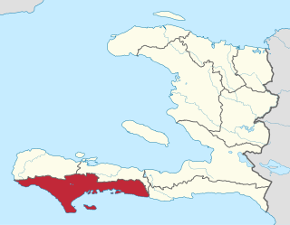
Sud is one of the ten departments of Haiti. It has an area of 2,653.60 square kilometres (1,024.56 sq mi) and a population of 774,976. Its capital is Les Cayes.

Carrefour, Ouest Commune and Department in Ouest, Haiti

Carrefour is a largely residential commune in the Port-au-Prince Arrondissement, in the Ouest department of Haiti. The commune had a population of 373,916 at the 2003 Census, and was officially estimated to have grown to 511,345 inhabitants in 2015. It is mostly a bedroom community for those who work in central Port-au-Prince.

Université dÉtat dHaïti university in Haiti

The Université d'État d'Haïti (UEH) is one of Haiti's most prestigious institutions of higher education. It is located in Port-au-Prince.

Cité Soleil Commune in Ouest, Haiti

Cité Soleil is an extremely impoverished and densely populated commune located in the Port-au-Prince metropolitan area in Haiti. Cité Soleil originally developed as a shanty town and grew to an estimated 200,000 to 400,000 residents, the majority of whom live in extreme poverty. The area is generally regarded as one of the poorest and most dangerous areas of the Western Hemisphere and it is one of the biggest slums in the Northern Hemisphere. The area has virtually no sewers and has a poorly maintained open canal system that serves as its sewage system, few formal businesses but many local commercial activities and enterprises, sporadic but largely free electricity, a few hospitals, and two government schools, Lycee Nationale de Cite Soleil, and Ecole Nationale de Cite Soleil. For several years until 2007, the area was ruled by a number of gangs, each controlling their own sectors. But government control was reestablished after a series of operations in early 2007 by the United Nations Stabilization Mission in Haiti (MINUSTAH) with the participation of the local population.

Kenscoff Commune in Ouest, Haiti

Kenscoff is a commune in the Port-au-Prince Arrondissement, in the Ouest department of Haiti, located in the foothills of the Chaîne de la Selle mountain range, some 10 kilometres to the southeast of the capital city of Port-au-Prince. The altitude is approximately 1500 meters, making the town the highest permanent settlement in the Caribbean. Because of its altitude, the temperature is on average cooler than the capital and during winter months can be chilly relative to the rest of the country. It has a population of around 52,200.

Pétion-Ville Commune in Ouest, Haiti

Pétion-Ville is a commune and a suburb of Port-au-Prince, Haiti, in the hills east and separate from the city itself on the northern hills of the Massif de la Selle. Founded in 1831 by then president Jean-Pierre Boyer, it was named after Alexandre Sabès Pétion (1770–1818), the Haitian general and president later recognized as one of the country's four founding fathers. The district is primarily a residential and touristic area. It held a population of 283,052 at the 2003 Census, which was officially estimated to have reached 376,834 in 2015. Many diplomats, foreign businessmen, and a large number of wealthy citizens do business and reside in Pétion-Ville.

Champ de Mars is a large public greenspace in Paris, France.

Adventist University of Haiti University

Adventist University of Haiti called in French:Université Adventiste d'Haïti is situated some five miles (8 km) southwest of Port-au-Prince, in the Carrefour neighborhood.

Port-au-Prince Arrondissement Arrondissement in Ouest, Haiti

Port-au-Prince is an arrondissement in the Ouest department of Haiti. It had 2,109,516 inhabitants at the 2003 Census which was estimated to have risen to 2,759,991 in 2015 in an area of 735.78 sq km. Postal codes in the Port-au-Prince Arrondissement start with the number 61.

Hôpital de la Trinité was a hospital in Port-au-Prince, Haïti. It was operated by the Médecins Sans Frontières (MSF) which operates an emergency clinic at the hospital and in three other centers in the capital. It was where most of the injured from the 2008 Pétion-Ville school collapse were treated. The hospital was destroyed in the 2010 Haiti earthquake; medical treatment by MSF staff was subsequently moved to improvised tent facilities adjacent to the hospital building.

Jimmy O Haitian hip hop artist

Jean Jimmy Alexandre, better known by his stage name Jimmy O, was a Haitian hip hop artist who was born in Port-au-Prince and lived in New York City. He was involved with Wyclef Jean's Yéle Haiti Foundation. Jimmy O performed his music in Haitian Creole.

National Museum of Haiti Haitian national history museum

The National Museum of Haiti in Port-au-Prince, Haiti, was completed in 1938. It is located at Route Nationale No. 1 in the neighborhood of Montrouis. It is not to be confused with the Musée du Panthéon National Haitien (MUPANAH), which is located across the street from the National Palace.

History of rail transport in Haiti

There are currently no functioning railways in Haiti and has never had any rail connections with the neighbouring Dominican Republic. However, between 1876 and about the 1970s, Haiti had various tramways and railways. A tram network operated in the capital, Port-au-Prince, between 1897 and 1932. Two railway lines, Port-au-Prince – Léogâne and Port-au-Prince – Manneville, along with some industrial lines, constituted the Haitian national rail network.

Haitian Carnival is a celebration held over several weeks each year leading up to Mardi Gras. Haitian Defile Kanaval is the Haitian Creole name of the main annual Mardi Gras carnival held in Port-au-Prince, Haiti.

Exposition internationale du bicentenaire de Port-au-Prince

The Exposition internationale du bicentenaire de Port-au-Prince was a world's fair held in Port-au-Prince, Haiti in 1949 to mark 200 years since Port-au-Prince's foundation.

The Port-au-Prince Haiti Temple is a temple of The Church of Jesus Christ of Latter-day Saints under construction in the Port-au-Prince suburb of Pétionville, Haiti. It is located adjacent to an existing meetinghouse at the intersection of Route de Frères and Impasse Saint-Marc.

References

  1. "The broken heart of Port-au-Prince: Champ de Mars · Visit Haiti". Visit Haiti. 2018-10-18. Retrieved 2019-04-25.
  2. 1 2 Clammer, Paul. (2012). Haiti. Chalfont St. Peter: Bradt Travel Guides. p. 116. ISBN   9781841624150. OCLC   801605883.
  3. "Champs de Mars | Port-Au-Prince & Around, Haiti Attractions". www.lonelyplanet.com. Retrieved 2019-04-25.
  4. "Haiti - Technology : The free internet a reality in the Champ de Mars - HaitiLibre.com : Haiti news 7/7". www.haitilibre.com. Retrieved 2019-04-25.

Coordinates: 18°32′36″N72°20′07″W / 18.54345°N 72.33533°W / 18.54345; -72.33533