
The Cascade Range or Cascades is a major mountain range of western North America, extending from southern British Columbia through Washington and Oregon to Northern California. It includes both non-volcanic mountains, such as the North Cascades, and the notable volcanoes known as the High Cascades. The small part of the range in British Columbia is referred to as the Canadian Cascades or, locally, as the Cascade Mountains. The latter term is also sometimes used by Washington residents to refer to the Washington section of the Cascades in addition to North Cascades, the more usual U.S. term, as in North Cascades National Park. The highest peak in the range is Mount Rainier in Washington at 14,411 feet (4,392 m).

The canton of Valais is one of the 26 cantons of Switzerland, situated in the southwestern part of the country, around the valley of the Rhône from its headwaters to Lake Geneva, separating the Pennine Alps from the Bernese Alps. The canton is simultaneously one of the driest regions of Switzerland in its central Rhône valley and among the wettest, having large amounts of snow and rain up on the highest peaks found in Switzerland. The canton of Valais is widely known for the Matterhorn and resort towns such as Crans-Montana, Saas Fee, Verbier and Zermatt. It is composed of 13 districts and its capital is Sion.

The Yellowhead Pass is a mountain pass across the Continental Divide of the Americas in the Canadian Rockies. It is located on the provincial boundary between the Canadian provinces of Alberta and British Columbia, and lies within Jasper National Park and Mount Robson Provincial Park.

Mount Ouray is a high and prominent mountain summit in the far southern Sawatch Range of the Rocky Mountains of North America. The 13,961-foot (4255.4 m) thirteener is located in San Isabel National Forest, 7.5 miles (12.0 km) west of Poncha Pass, Colorado, United States, on the boundary between Chaffee and Saguache counties. The mountain was named in honor of Ute Chief Ouray.

The Ultra-Trail du Mont-Blanc (UTMB) is a single-stage mountain ultramarathon first held in 2003. It is a race of the Ultra-Trail World Tour.

The Tour du Mont Blanc or TMB is one of the most popular long-distance walks in Europe. It circles the Mont Blanc massif, covering a distance of roughly 170 kilometres (110 mi) with 10 kilometres (6.2 mi) of ascent/descent and passes through parts of Switzerland, Italy and France.

Lac de Champex is a lake in Valais, Switzerland. Its surface area is 11 ha. On the shores lies the village of Champex.

Champex is a village located in the French-speaking Swiss canton of Valais, part of the municipality of Orsières.

Wallface Mountain is a mountain located in Essex County, New York. The mountain is named after the cliff on its southeastern side. Wallface is flanked to the west by MacNaughton Mountain, and faces Mount Marshall to the southeast across Indian Pass.

Le Génépi is a mountain of the Swiss Mont Blanc massif, located west of Champex in the canton of Valais. It is the culminating point of the group lying north of the Fenêtre d'Arpette.
La Breya is a mountain of the Mont Blanc massif, overlooking Champex in the canton of Valais. It is accessible by chair lift from Champex, the upper station being located at Grands Plans. From there a trail leads to its summit.
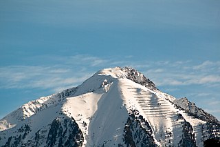
Le Catogne is a mountain on the extreme north-eastern edge of the Mont Blanc massif, overlooking Champex in the Swiss canton of Valais. Some sources consider this summit as being within the Pennine Alps.
Bush Pass is a mountain pass in the Canadian Rockies, on the border between the Canadian provinces of Alberta and British Columbia. it is located at the headwaters of the Valenciennes River, formerly known as the South Fork Bush River; the North Fork Bush River is now known as the Bush River.

The Pointe des Ecandies is a mountain of the Mont Blanc Massif, located between Trient and Champex in the canton of Valais. It is located north of the Pointe d'Orny and east of the Trient Glacier.

Vermilion Pass is a high mountain pass in the Canadian Rockies, traversing the continental divide. It connects Kootenay National Park in the province of British Columbia with Banff National Park in Alberta.
Carcajou Pass is a mountain pass on the Continental Divide and British Columbia–Alberta boundary at the north end of Mount Robson Provincial Park. On the Alberta side lies the northwestern part of Jasper National Park. Carcajou is the French word for "wolverine".
Tonquin Pass, 1948 m (6393 ft), is a mountain pass in the Canadian Rockies, linking Tonquin Valley in Jasper National Park, Alberta, to Mount Robson Provincial Park and adjoining areas of British Columbia. It is at the headwaters of Tonquin Creek, which flows into British Columbia. Located on the interprovincial boundary, it is on the Continental Divide.
The 2015 Tour de Romandie was the 69th edition of the Tour de Romandie stage race. It took place from 28 April to 3 May and was the fourteenth race of the 2015 UCI World Tour. The race took place around the Romandie region of Switzerland, starting in Lac de Joux and finishing in Lausanne. The race includes six stages, with a team time trial at the beginning and an individual time trial at the end and four hilly or mountainous stages in between. The queen stage is the fifth stage, which finishes on the climb above Champex-Lac.


