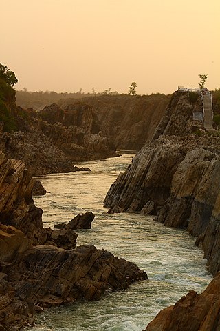
The Narmada River, previously also known as Narbada or anglicised as Nerbudda, is the 5th longest river in India and overall the longest west-flowing river in the country. It is also the largest flowing river in the state of Madhya Pradesh. This river flows through the states of Madhya Pradesh and Gujarat in India. It is also known as the "Lifeline of Madhya Pradesh and Gujarat" due to its huge contribution to the two states in many ways. The Narmada River rises from the Amarkantak Plateau in Anuppur district in Madhya Pradesh. It forms the traditional boundary between North and South India and flows westwards for 1,312 km (815.2 mi) before draining through the Gulf of Khambhat into the Arabian Sea, 30 km (18.6 mi) west of Bharuch city of Gujarat.

The Satpura Range is a range of hills in central India. The range rises in eastern Gujarat running east through the border of Maharashtra and Madhya Pradesh and ends in Chhattisgarh. The range parallels the Vindhya Range to the north, and these two east–west ranges divide Indian Subcontinent into the Indo-Gangetic plain of northern India and the Deccan Plateau of the south. The Narmada River originates from north-eastern end of Satpura in Amarkantak, and runs in the depression between the Satpura and Vindhya ranges, draining the northern slope of the Satpura range, running west towards the Arabian Sea. The Tapti River originates in the eastern-central part of Satpura, crossing the range in the center and running west at the range's southern slopes before meeting the Arabian Sea at Surat, draining the central and southern slopes of the range. Multai, the place of Tapi river origin is located about 465 kilometer far, south-westerly to Amarkantak, separated across by the hill range. The Godavari River and its tributaries drain the Deccan plateau, which lies south of the range, and the Mahanadi River drains the easternmost portion of the range. The Godavari and Mahanadi rivers flow into the Bay of Bengal. At its eastern end, the Satpura range meets the hills of the Chotanagpur Plateau. The Satpura Range is a horst mountain and is flanked by Narmada Graben in the north and much smaller but parallel Tapi Graben in the south.

The Wainganga is a river in India originating in the Mahadeo Hills in Mundara in Gondwana region near the village Gopalganj in Seoni, Madhya Pradesh. It is a key tributary of the Godavari. The river flows south in a winding course through the states of Madhya Pradesh and Maharashtra, roughly 580 km (360 mi). After joining the Wardha River, the united stream, which is known as the Pranahita River, empties into the Godavari River at Kaleshwaram, Telangana.

The Betwa is a river in Central and Northern India, and a tributary of the Yamuna. It rises in the Vindhya Range (Raisen) just north of Hoshangabad (Narmadapuram) in Madhya Pradesh and flows northeast through Madhya Pradesh and Orchha to Uttar Pradesh. Nearly half of its course, which is not navigable, runs over the Malwa Plateau. The confluence of the Betwa and the Yamuna rivers is in Hamirpur district in Uttar Pradesh.
The Chambal River is a tributary of the Yamuna River in Central and Northern India, and thus forms part of the drainage system of the Ganges. The river flows north-northeast through Madhya Pradesh, running for a time through Rajasthan, then forming the boundary between Rajasthan and Madhya Pradesh before turning southeast to join the Yamuna in Uttar Pradesh state.

The Kali Sindh (Krashna Sindhu), is a river in Madhya Pradesh and Rajasthan in northern India. It is a tributary of the Chambal River in the Ganges Basin. The main tributaries of the Kali Sindh are the Parwan, Niwaj and Ahu rivers. The Kali Sindh River drains a major portion of the Malwa region, and is the biggest river flowing in the Malwa region of Madhya Pradesh.

The Wardha River, also known as the Varada River, is a major river in Vidarbha, Maharashtra, which originates in the Satpura Range and flows into the Wain ganga river to form the Pranhita river which finally joins the Godavari river.
Balaghat is a city and a municipality in Balaghat district, in the state of Madhya Pradesh, India. It is the administrative headquarters of Balaghat District. Wainganga River flows beside the town.

The Purna River is a river of Central and Western India. It is one of the chief tributaries of the Tapti river and empties into it at Changdev in Jalgaon, Maharashtra.

Balaghat district is a district of Madhya Pradesh state in Central India.

Seoni District is a district of Madhya Pradesh state in central India. The town of Seoni is the district headquarters.

Seoni is a city and a municipality in Seoni district in the Indian state of Madhya Pradesh. This tribal household dominated district was formed in the year 1956.

Rajgarh district is a district of Madhya Pradesh in central India. The city of Rajgarh is the administrative headquarters of the district. The old name of Rajgarh was Jhanjhanipur. Rajgarh in Madhya Pradesh is one of the aspirational districts selected by Government of India. The district has an area of 6,154 km² and the population is 1,545,814. The district lies on the northern edge of the Malwa plateau, and the Parbati River forms the eastern boundary of the district, while the Kali Sindh River forms the western boundary. The district has seven tehsils, Rajgarh, Khilchipur, Jirapur, Biaora, Narsinghgarh, Sarangpur and Pachore. The district is bounded by Rajasthan state to the north, and by the districts of Guna to the northeast, Bhopal to the east, Sehore to the southeast, and Shajapur to the south and west. It is part of Bhopal Division. There are 1728 villages in Rajgarh.

The Indira Sagar Dam is the largest dam in India, in terms of volume of water stored in the reservoir. It is located on the Narmada River at the town of Narmada Nagar, Punasa in the Khandwa district of Madhya Pradesh in India. The foundation stone of the project was laid by the prime minister of India Indira Gandhi on 23 October 1984. The construction of the main dam started in 1992. The downstream projects of ISP are Omkareshwar, Maheshwar, and Sardar Sarovar Project. To build it, a town of 22,000 people and 100 villages was displaced.
Waraseoni is a tehsil and Nagar Palika Parishad (municipality) in Balaghat district in the Indian state of Madhya Pradesh. It is situated 16 km (10 mi) from the district headquarters. Waraseoni is second most populous town in Balaghat District after Balaghat.
Narmada Valley Development Authority (NVDA) concerns Narmada River, the river of Madhya Pradesh. With 87% of its catchment area lying in Madhya Pradesh, it becomes all the more important for the state to exploit this enormous water resource. It was with this motto in mind that the Narmada Valley Development Authority (NVDA) was formed by the government of MP on 9 August 1985. NVDA oversees all major development projects in the Narmada Basin. The body also ensures that proper rehabilitation is provided to the displaced, and the negative impacts on environment are minimized by taking appropriate measures.

The Kanhan River is an important right bank tributary of the Wainganga River draining a large area lying south of Satpura range in central India. Along its 275 km run through the Indian States of Maharashtra and Madhya Pradesh, it receives its largest tributary - Pench River, a major water source for the metropolis of Nagpur.
Lalbarra, alternatively Lalburra is a small town and serves as headquarter of Lalburra tehsil. It is a tehsil (sub-district) of Balaghat district in the state of Madhya Pradesh, India. It is located on State Highway 26, on the edge of Pench National Park. Its Postal Index Number is 481441.
Lanji is a statutory town in the Lanji tehsil of Balaghat district in Madhya Pradesh, India. It is administered by a nagar panchayat, and is part of the Lanji assembly constituency and the Lanji community development block.
Rampayli is a town located in Balaghat District, Madhya Pradesh.