Related Research Articles

Dehradun, also known as Dehra Doon, is the winter capital and the most populous city of the Indian state of Uttarakhand. It is the administrative headquarters of the eponymous district and is governed by the Dehradun Municipal Corporation, with the Uttarakhand Legislative Assembly holding its winter sessions in the city as its winter capital. Part of the Garhwal region, and housing the headquarters of its Divisional Commissioner, Dehradun is one of the "Counter Magnets" of the National Capital Region (NCR) being developed as an alternative centre of growth to help ease the migration and population explosion in the Delhi metropolitan area and to establish a smart city in the Himalayas.
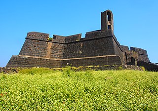
The Worli Fort is a fort in Worli, Mumbai, India. Though often incorrectly assumed to have been built by the Portuguese, the fort was built by the British around 1675 on Worli Hill. Worli Fort overlooked Mahim Bay at a time when the city comprised just seven islands and was used as a lookout for enemy ships.
Moulvibazar District, also spelled Moulavibazar, or Maulavibazar, is the southeastern district of Sylhet Division in northeastern Bangladesh, named after the town of Moulvibazar. It is bordered by the Indian states of Tripura and Assam to the south and east, respectively; by the Bangladeshi districts of Habiganj to the west and Sylhet to the north.
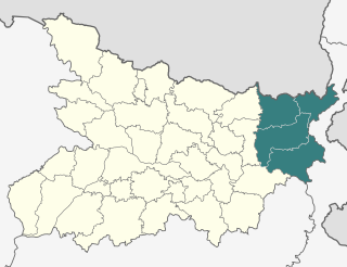
Purnia division is an administrative geographical unit of Bihar state of India. Purnia is the administrative headquarters of the division. The division consists of Purnia district, Katihar district, Araria district, and Kishanganj district. It was established in 1990. It is also known as Seemanchal. It is a part of the Kosi—Seemanchal subregion of the cultural Mithila region.

Fiji–India relations are the foreign relations between Fiji and India. Fiji has a high commission in New Delhi, whilst India has a high commission in Suva.

Mahad ( [məɦaːɖ]) is a city in Raigad district situated in the North Konkan region of Maharashtra state, India. It is located 108.5 km (67.4 mi) from District Headquarters Alibag, and 167 km (104 mi) from Mumbai. Mahad is known for Raigad Fort, the capital of the Maratha Empire in Shivaji Maharaj's era and the revolutionary Mahad Satyagraha launched by at Chavdar Tale in the wake of modern India.

Doiwala is a town and a Nagar Palika in Dehradun district in the state of Uttarakhand, India.

Jiaganj Azimganj is a city and a municipality in Murshidabad district in the Indian state of West Bengal.

Kiriburu is a census town in Odisha. The town is mainly known for having big Iron-ore Mines KIOM & MIOM both governed by Steel Authority of India Limited (SAIL). The road connecting the township to the mines is divided by the border of Odisha and Jharkhand. It is also a famous hill station situated in the core of Saranda forest. Saranda forest is land of seven hundred hills. The name of the forest Saranda is due to the large number of elephants found in this forest. The forest has some waterfalls.

Pahalgam, known as Pahalgom is a town and a notified area committee, near Anantnag city in the Anantnag district of the Indian-administered union territory of Jammu and Kashmir. It is a popular tourist destination and hill station. Its lush green meadows and pristine waters attract thousands of tourists from all over the world each year. It is located 45 kilometres (28 mi) from Anantnag on the banks of Lidder River at an altitude of 7,200 feet (2,200 m). Pahalgam is the headquarters of one of the eleven tehsils of Anantnag district.

The Rambagh Palace in Jaipur, Rajasthan is the former residence of the Maharaja of Jaipur located 5 miles (8.0 km) outside the walls of the city of Jaipur on Bhawani Singh Road.
Darbhanga Colony is a posh central neighborhood in Prayagraj, India. It was formerly owned by the royal family of Darbhanga. It still houses the Lowther Castle in the colony. Darbhanga Colony played important a role in Independence movement of India as the Fourth and Eighth annual convention of Indian National Congress was held in here.

Harnaut is a Nagar panchayat and corresponding Block in the Nalanda District of Bihar, India. The Hindu, Buddhist and Jain pilgrim centres of Nalanda, Pawapuri, Rajgir, Bodh Gaya and Vaishali are all near Harnaut. The incumbent Chief Minister of Bihar, Nitish Kumar, is from Kalyan Bigha village near Harnaut.

The Central Business District of Belapur is a large upmarket neighbourhood of Navi Mumbai. The Navi Mumbai Municipal Corporation is headquartered in Belapur. The Reserve Bank of India maintains a branch office at CBD Belapur. This area is one of the fastest developing regions in Navi Mumbai in terms of new residential and commercial construction projects. CBD Belapur is connected to other parts of Mumbai through railways, BEST & NMMT buses. It had a ferry service for traveling to Elephanta caves from Sector-11.

Jinnah International Airport, formerly Drigh Road Airport or Karachi Civil Airport, is Pakistan's busiest international and domestic airport, and handled 7,267,582 passengers in 2017–2018. Located in Karachi, the largest city and commercial capital of Pakistan and capital of the province of Sindh, it is named after Muhammad Ali Jinnah, the statesman founder of Pakistan. It is one of the oldest continuously-operating airports in the world.

Attapur is a commercial and residential area located in South western Hyderabad, Telangana.

The Song River in Dehradun district drains the central and eastern part of the Doon Valley, in the state of Uttarakhand, India. A tributary of Sooswa river, which in turn is a tributary of the Ganges, it originates as spring-fed stream in the southern slopes of the Radi Top of Mussoorie ridge of the Himalayan range and runs from Dhanaulti towards Narendranagar. As is common in hilly areas, there are several streams running south from the mountains that merge into one river that emerges from the hills a little after Sahastradhara.
Moinuddin Ahmed Chowdhury was a politician in East Pakistan, social benefactor, and member of the Ghugudanga Zamindar family.
Prayagraj Rambagh railway station is situated in the Rambagh area of Prayagraj in the Indian state of Uttar Pradesh. It also a Terminal station of Prayagraj. Due to huge rush at Prayagraj Junction the railway will develop as a high facilitated terminal.
Ahmed satellite station is the second-oldest satellite station in India. Built with the intention of providing New Delhi with satellite coverage and promoting cross-country exchange of information, the satellite station was inaugurated on 25 February 1977 and named after the former president Fakhruddin Ali Ahmed. The station was reputably built at a cost of ₹100 million, with 60% of the station built indigenously and the other fraction purchased with help from a loan from Canada. It was built to conform to the strictest standards of the time and was predicted to be 99.99% accurate, with its tracking system accurate to 1/100 of a degree. It is situated in the Doiwala region of Dehradun, just off the nearby village of Chandmari, nestled in the sal trees of the region – a location chosen for its isolated natural surroundings and their capacity to function as a barrier to microwave or radio noise.
References
- ↑ "Ahmed Satellite station".
- ↑ India Telecom Series: Vol. 2: Cellular & Wireless Markets. Information Gatekeepers Inc. ISBN 9781568512211.
- ↑ "India's space odyssey".