Chapples Park

Last updated
Chapples Park
Type Golf course, public park
Location Thunder Bay, Ontario, Canada
Area 120 hectares (300 acres)
Operated by City of Thunder Bay

Chapples Park is located in the centre of Fort William, Ontario, which today forms the south end of Thunder Bay. It forms a key part of Thunder Bay's recreation trail system.

Fort William, Ontario former city in Ontario, Canada, amalgamated with Port Arthur to form Thunder Bay in 1970

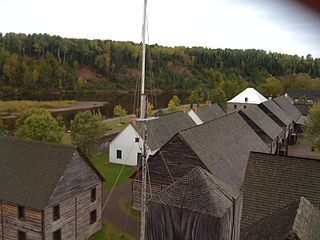
Fort William was a city in Northern Ontario, located on the Kaministiquia River, at its entrance to Lake Superior. It amalgamated with Port Arthur and the townships of Neebing and McIntyre to form the city of Thunder Bay in January 1970. Since then it has been the largest city in Northwestern Ontario. The city's Latin motto was A posse ad esse featured on its coat of arms designed in 1900 by town officials, "On one side of the shield stands an Indian dressed in the paint and feathers of the early days; on the other side is a French voyageur; the center contains an elevator, a steamship and a locomotive, while the beaver surmounts the whole."

Ontario Province of Canada

Ontario is one of the 13 provinces and territories of Canada and is located in east-central Canada. It is Canada's most populous province accounting for 38.3 percent of the country's population, and is the second-largest province in total area. Ontario is fourth-largest jurisdiction in total area when the territories of the Northwest Territories and Nunavut are included. It is home to the nation's capital city, Ottawa, and the nation's most populous city, Toronto, which is also Ontario's provincial capital.

Thunder Bay City in Ontario, Canada

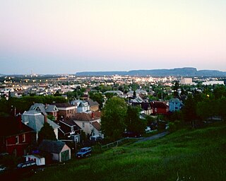
Thunder Bay is a city in, and the seat of, Thunder Bay District, Ontario, Canada. It is the most populous municipality in Northwestern Ontario with a population of 107,909 as of the Canada 2016 Census, and the second most populous in Northern Ontario after Greater Sudbury. Located on Lake Superior, the census metropolitan area of Thunder Bay has a population of 121,621, and consists of the city of Thunder Bay, the municipalities of Oliver Paipoonge and Neebing, the townships of Shuniah, Conmee, O'Connor, and Gillies, and the Fort William First Nation.

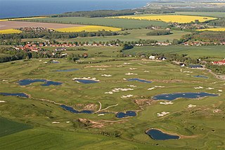
The park's main feature is an 18-hole, 6,236 yards (5,702 m), par 71 golf course operated by the city. The course includes a practice range. [1] In the centre of the park is a recreation area featuring tennis courts, a soccer field, and baseball diamonds.

Golf course series of holes designed for the game of golf

A golf course is the grounds where the game of golf is played. It comprises a series of holes, each consisting of a teeing ground, a fairway, the rough and other hazards, and a green with a flagstick ("pin") and hole ("cup"). A standard round of golf consists of 18 holes. Most courses contain 18 holes; some share fairways or greens, and a subset has nine holes, played twice per round. Par-3 courses consist of nine or 18 holes all of which have a par of three strokes.

The Thunder Bay Botanical Conservatory is located on the eastern edge of the park, accessible via Dease Street. The conservatory displays plants from around the world in a tropical setting. The facility was first opened in 1967 as a centennial project. [2]

Conservatory (greenhouse) greenhouse

A conservatory is a building or room having glass or tarpaulin roofing and walls used as a greenhouse or a sunroom. If in a residence, it would typically be attached to the house on only one side. Conservatories originated in the 16th century when wealthy landowners sought to cultivate citrus fruits such as lemons and oranges that began to appear on their dinner tables brought by traders from warmer regions of the Mediterranean. Municipal conservatories became popular in the early 19th century.

Canadian Centennial 100th anniversary of the Canadian Confederation in 1967

The Canadian Centennial was a yearlong celebration held in 1967 when Canada celebrated the 100th anniversary of the Canadian Confederation. Celebrations occurred throughout the year but culminated on Dominion Day, July 1, 1967. Coins were different from other years' issues, with animals on each — the cent, for instance, had a dove on its reverse. Communities and organizations across Canada were encouraged to engage in Centennial projects to celebrate the anniversary. The projects ranged from special one-time events to local improvement projects, such as the construction of municipal arenas and parks. The Centennial Flame was also added to Parliament Hill. Children born in 1967 were declared Centennial babies.

See also

Thunder Bay Soroptimist International Friendship Garden

The Thunder Bay Soroptimist International Friendship Garden is a city park located in the south end of Thunder Bay, Ontario, Canada. The park is located at the south end of Chapples Park, at the corners of Victoria Avenue and Hyde Park Avenue.

Fort William Stadium is a soccer, football, and track and field stadium in Thunder Bay, Ontario And is part of the Royal Canadian Legion Sports Complex. It has a seating capacity of 3,500, Many upgrades have been made to the complex, including scoreboard, lights and field size.

Related Research Articles

Port Arthur was a city in Northern Ontario, Canada, located on Lake Superior. In January 1970 it amalgamated with Fort William and the townships of Neebing and McIntyre to form the city of Thunder Bay.

Fort William Historical Park

Fort William Historical Park is a Canadian historical site located in Thunder Bay, Ontario, that contains a reconstruction of the Fort William fur trade post as it existed in 1816. It officially opened on July 3, 1973.

Greater Victoria Metropolitan area in British Columbia, Canada

Greater Victoria is located in British Columbia, Canada, on the southern tip of Vancouver Island. It is a cultural rather than political entity, usually defined as the thirteen easternmost municipalities of the Capital Regional District (CRD) on Vancouver Island as well as some adjacent areas and nearby islands. The Capital Regional District administers some aspects of public administration for the whole metro region; other aspects are administered by the individual member municipalities of Greater Victoria. Roughly, Greater Victoria consists of all land and nearby islands east of a line drawn from the southern end of Finlayson Arm to the eastern shore of Sooke Harbour, along with some lands on the northern shore of Sooke Harbour.

Thunder Bay International Airport airport in Thunder Bay, Ontario, Canada

Thunder Bay International Airport,, is an airport in the city of Thunder Bay, Ontario, Canada. With 108,130 aircraft movements in 2012, it was the fourth busiest airport in Ontario and the 16th busiest airport in Canada. During the same year, more than 761,000 passengers went through the airport.

Thunder Bay (Ontario landform) bay in Ontario, Canada

Thunder Bay is a large bay on the northern shore of Lake Superior, in Thunder Bay District, Ontario, Canada. The bay is about 50 kilometres (31 mi) long and 22 kilometres (14 mi) wide. It is bordered to the east by the Sibley Peninsula at the southern tip of which is Thunder Cape, marking the entrance to the bay for ships approaching from the east. The mesas and sills on the peninsula are known as the Sleeping Giant due to their appearance when viewed from Thunder Bay.

Thunder Bay Transit

Thunder Bay Transit is the public transit operator in Thunder Bay, Ontario, Canada. It was formed in 1970, after the amalgamation of the cities of Port Arthur and Fort William and their respective transit agencies. Thunder Bay Transit is a member of the Canadian Urban Transit Association.

The Brooklyn–Queens Greenway is a bicycling and pedestrian path connecting parks and roads in the New York City boroughs of Brooklyn and Queens, connecting Coney Island in the south to Fort Totten in the north, on Long Island Sound. The route connects major sites in the two boroughs, such as the New York Aquarium, Brooklyn Museum, the Brooklyn Botanic Garden, the New York Hall of Science and Citi Field.

Current River, Thunder Bay, Ontario human settlement in Canada

Current River is a neighbourhood located north east of Port Arthur in the city of Thunder Bay, Ontario. It is separated from the main urban area of Thunder Bay by the Current River Greenway, a large parkland along the river after which the neighbourhood was named. It is home to approximately 4,780 people and has an ageing and declining population.

Downtown Fort William, Ontario human settlement in Canada

Downtown Fort William, also known as Downtown Thunder Bay South or the South Core, is the urban core of the former city of Fort William, the southern half of Thunder Bay, Ontario. It is centred on Victoriaville Civic Centre, an indoor shopping mall and civic centre built as part of an urban renewal project in the 1980s. It is separated from the Kaministiquia River by the Canadian Pacific Railway line, and its topography is relatively flat.

Northwood is a neighbourhood in the city of Thunder Bay, Ontario. It is one of Thunder Bay's seven municipal wards, represented by Shelby Ch'ng. It was developed between 1965 and 1985. It is bounded by Chapples Park to the east, Arthur Street to the south, the Thunder Bay Expressway to the west and the Harbour Expressway to the north.

Hillcrest Park (Thunder Bay)

Hillcrest Park is a public park located in Thunder Bay, Ontario. The Park is located in the city's north end. The Park's location provides scenic views of the city, the harbour, and the Sleeping Giant. Located within the park is a World War II memorial for the Lake Superior Regiment. The memorial includes an honour roll of those killed in action, and a Universal Carrier; a vehicle used by the regiment. Located at the north end of the park is the Sunken Gardens with over 70 varieties of flowers in a unique configuration of walkways and benches.

The Centennial Conservatory in Thunder Bay, Ontario is located in the city's south end. It was built in 1965 and opened to the public in 1967 as a Centennial Project to commemorate the Canadian Centennial. The conservatory houses various varieties of tropical plants, flowers, trees and shrubs in its main greenhouse, a cactus room, and a room with seasonal displays. The facility includes paths and benches and a wishing well and is open to the public, year round free of charge.

The Lac des Mille Lacs First Nation, also known as Nizaatikoong, is a Saulteaux Ojibwe First Nation band government. The nation owns two reserves in the Thunder Bay District of Ontario, Lac des Mille Lacs 22A1 on the northeastern shore of Lac des Mille Lacs and Lac des Mille Lacs 22A2 at the junction of the Seine and Firesteel Rivers.

James Hugh Jessiman was a Canadian politician, who represented Fort William in the Legislative Assembly of Ontario from 1967 to 1975 as a Progressive Conservative member.

Chapples Park Stadium is a 2,000 seated stadium in Fort William, southern Thunder Bay, Ontario. It's mostly used for association football, in which it was home to Thunder Bay Chill between 2004–2013.

References

  1. Golf Thunder Bay - Chapples Golf Course Archived October 27, 2007, at the Wayback Machine .. Retrieved November 28, 2008
  2. City Parks - Botanical Conservatory Archived February 7, 2009, at the Wayback Machine .. Retrieved November 28, 2008.

Coordinates: 48°23′35″N89°15′55″W / 48.39306°N 89.26528°W / 48.39306; -89.26528

Geographic coordinate system Coordinate system

A geographic coordinate system is a coordinate system that enables every location on Earth to be specified by a set of numbers, letters or symbols. The coordinates are often chosen such that one of the numbers represents a vertical position and two or three of the numbers represent a horizontal position; alternatively, a geographic position may be expressed in a combined three-dimensional Cartesian vector. A common choice of coordinates is latitude, longitude and elevation. To specify a location on a plane requires a map projection.