
The Havel is a river in northeastern Germany, flowing through the states of Mecklenburg-Vorpommern, Brandenburg, Berlin and Saxony-Anhalt. It is a right tributary of the Elbe and 325 kilometres (202 mi) long. However, the direct distance from its source to its mouth is only 94 kilometres (58 mi). For much of its length, the Havel is navigable; it provides an important link in the waterway connections between the east and west of Germany, as well as beyond.

The Spree is, with a length of approximately 400 kilometres (250 mi), the main tributary of the River Havel, and at their confluence in Berlin-Spandau, is much longer than the Havel, which itself flows into the Elbe at Havelberg. The river rises in the Lusatian Highlands, that are part of the Sudetes, in the Lusatian part of Saxony, where it has three sources: the historical one called Spreeborn in the village of Spreedorf, the water-richest one in Neugersdorf, and the highest elevated one in Eibau. The Spree then flows northwards through Upper and Lower Lusatia, where it crosses the border between Saxony and Brandenburg. After passing through Cottbus, it forms the Spree Forest, a large inland delta and biosphere reserve. It then flows through Lake Schwielochsee before entering Berlin, as Müggelspree(listen ).
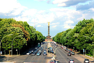
The Straße des 17. Juni, is a street in central Berlin, the capital of Germany. Its name refers to the 17 June 1953 uprising in East Germany. It is the western continuation of the boulevard Unter den Linden. It runs east–west through the Tiergarten, a large park to the west of the city centre. At the eastern end of the street is the Brandenburg Gate and the Platz des 18. März, it then passes the Soviet War Memorial before passing either side of Victory Column (Siegessäule) in the middle of the park, and out of the park through the Charlottenburg Gate, terminating about half a kilometre later at Ernst-Reuter-Platz. The street is a section of the main western thoroughfare radiating out from the centre of Berlin so the road continues to the west of Ernst-Reuter-Platz, the first section of which is called Bismarckstraße.

The Mittelland Canal, also known as the Midland Canal, is a major canal in central Germany. It forms an important link in the waterway network of that country, providing the principal east-west inland waterway connection. Its significance goes beyond Germany as it links France, Switzerland and the Benelux countries with Poland, the Czech Republic and the Baltic Sea.

The Dahme is a river that flows through the German states of Brandenburg and Berlin. It is a left bank tributary of the River Spree and is approximately 95 kilometres (59 mi) long.

The Wasserschutzpolizei is the river police that patrols the waterways, lakes and harbours of Germany around the clock. The WSP are part of the Landespolizei. The Federal Police maintains 16 patrol craft and helicopters are part of the Coast Guard (Küstenwache) and assigned to coastal BPOL stations. The watercraft include six offshore patrol vessels, e.g. those of the Bad Bramstedt class, as well as a number of fast inshore vessels and one tugboat.
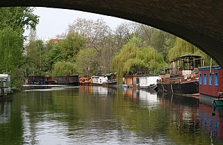
The Landwehr Canal, or Landwehrkanal in German, is a 10.7-kilometre (6.6 mi) long canal parallel to the Spree river in Berlin, Germany, built between 1845 and 1850 according to plans by Peter Joseph Lenné. It connects the upper part of the Spree at the Osthafen in Friedrichshain with its lower part in Charlottenburg, flowing through Kreuzberg and Tiergarten.
Berlin has developed a highly complex transportation infrastructure providing very diverse modes of urban mobility. 979 bridges cross 197 kilometers of innercity waterways, 5,334 kilometres (3,314 mi) of roads run through Berlin, of which 73 kilometres (45 mi) are motorways. Long-distance rail lines connect Berlin with all of the major cities of Germany and with many cities in neighboring European countries. Regional rail lines provide access to the surrounding regions of Brandenburg and to the Baltic Sea.

The Oder is a river in Central Europe. It is Poland's second-longest river in total length and third-longest within its borders after the Vistula and Warta. The Oder rises in the Czech Republic and flows 742 kilometres (461 mi) through western Poland, later forming 187 kilometres (116 mi) of the border between Poland and Germany as part of the Oder–Neisse line. The river ultimately flows into the Szczecin Lagoon north of Szczecin and then into three branches that empty into the Bay of Pomerania of the Baltic Sea.

The Oder–Spree Canal, or the Oder-Spree-Kanal in German, is a canal in the east of Germany. It links the Dahme river, at Schmöckwitz in the south-eastern suburbs of Berlin, with the River Oder, at Eisenhüttenstadt. It provides an important commercial navigable connection between Berlin and the Oder, and hence Poland.

The Seddinsee is a lake in the south-eastern outskirts of Berlin, the capital city of Germany. The lake is aligned south-west to north-east, with its south-western end adjacent to the Berlin suburb of Schmöckwitz. Here the Seddinsee meets the Zeuthener See and Langer See, two lakes that form part of the course of the River Dahme.

The Langer See is a lake situated in the south-eastern outskirts of Berlin, the capital city of Germany. The lake is aligned south-east to north-west and forms part of the course of the River Dahme. The Langer See is approximately 11 kilometres (6.8 mi) long, with an average width of 221 metres (725 ft) and an area of 2.43 square kilometres (0.94 sq mi).
The Teltow Canal, also known as the Teltowkanal (help·info) in German, is a canal to the south of Berlin, the capital city of Germany. The canal lies in both the states of Berlin and Brandenburg, and at points forms the boundary between the two. It takes its name from the Brandeburgian region of Teltow and town of Teltow which lie on its course. The canal was constructed between 1900 and 1906, when it was opened by Wilhelm II.

The Luisenstadt Canal, or Luisenstädtischer Kanal, is a 2.3-kilometre-long (1.4 mi) former canal in Berlin, Germany. It is named after the Luisenstadt district and ran through today's districts of Kreuzberg and Mitte, linking the Landwehr Canal with the Spree River, and serving a central canal basin known as the Engelbecken or Angel's Pool. The canal is named after Queen Louise, the wife of King Friedrich Wilhelm III.

The Neukölln Ship Canal, or Neuköllner Schiffahrtskanal, is a 4.1-kilometre (2.5 mi) long canal in Berlin, Germany. It connects with the Landwehr Canal at its northern end, and with the Teltow Canal and the Britz Canal at its southern end.

The Britz Canal, or Britzer Verbindungskanal in German, is a 3.4-kilometre (2.1 mi) long canal in Berlin, Germany. The canal was built between 1900 and 1906, and was previously known as the Britz Branch Canal or Britzer Zweigkanal.

The Berlin-Spandau Ship Canal, or Berlin-Spandauer Schifffahrtskanal in German, is a canal in Berlin, Germany. It was built between 1848 and 1859 to a plan created by Peter Joseph Lenné, and was formerly known as the Hohenzollern Canal or Hohenzollernkanal.

The Westhafen Canal, or Westhafenkanal in German, is a canal in Berlin, Germany. The 3.1-kilometre (1.9 mi) long canal connects with the Westhafen inland port and the Berlin-Spandau Ship Canal at its eastern end, and with the River Spree in Charlottenburg at its western end. It has no locks.
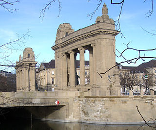
Charlottenburg Gate with Charlottenburg Bridge is a Neo-Baroque structure in the Charlottenburg district of Berlin. Erected in 1907 at the behest of the then independent City of Charlottenburg, it was meant as a counterpart to Berlin's Brandenburg Gate.

The Westhafen is Berlin's largest inland port, located in the district of Moabit.

