
Stutsman County is a county in the U.S. state of North Dakota. As of the 2020 census, the population was 21,593, making it the 10th most populous county in North Dakota. Its county seat is Jamestown.

Kidder County is a county located in the U.S. state of North Dakota. As of the 2020 census, the population was 2,394. Its county seat is Steele.

The Lower Klamath National Wildlife Refuge is a National Wildlife Refuge of the United States on the border between California and Oregon. It is operated by the United States Fish and Wildlife Service. The refuge was designated a National Historic Landmark on October 16, 1965.
Huron Wetland Management District is located in the U.S. state of South Dakota and includes 17,518 acres (70.89 km2). The refuge borders the Missouri River on the east and is managed by the U.S. Fish and Wildlife Service. Huron WMD covers eight counties in east-central South Dakota. The topography of this area ranges from flat, gently rolling drift prairie to the Missouri Coteau hills in the western end of the district. The district lies in the midst of the world-renowned Prairie Pothole Region.

Chase Lake National Wildlife Refuge is located in the U.S. state of North Dakota around Chase Lake. The majority of the land area of the refuge has been designated as wilderness and is known as the Chase Lake Wilderness. The refuge is one of the oldest in the U.S., having been set aside in 1908. The refuge is home to one of the largest nesting colonies of white pelicans than any other protected area in the U.S.
The Arrowwood National Wildlife Refuge Complex consists of numerous National Wildlife Refuges and Wetland Management Districts in the U.S. state of North Dakota. Altogether, twelve separate areas are in the complex, with the Chase Lake Prairie Project being the largest at 5.5 million acres (22,000 km2).

Chase Lake Wetland Management District is located in the U.S. state of North Dakota around Chase Lake. The district is located in what is known as the Prairie Pothole Region of lakes and ponds, which were left behind by the retreat of glaciers at the end of the last ice age. It was established in 1993.

The Chase Lake Prairie Project is considered the "National Flagship Project" of the North American Waterfowl Management Plan (NAWMP). The goal is to rehabilitate 5,500,000 acres (2,200,000 ha) of wetland around Chase Lake on the Missouri Coteau. The project was dedicated in September 1989.
The Half-Way Lake National Wildlife Refuge is located in the U.S. state of North Dakota and consists of 160 acres (0.65 km2). The refuge is a "limited-interest" refuge, which is privately owned easement refuge, managed by the U.S. Fish and Wildlife Service. The refuge is closed to the public and was established to protect habitat for migratory bird species and other animal life. Chase Lake Wetland Management District oversees the refuge, which in turn is a part of the Arrowwood National Wildlife Refuge Complex.
The Valley City Wetland Management District is located in the U.S. state of North Dakota and consists of 76,000 acres (307 km2). The wetland district is a substation of the Arrowwood National Wildlife Refuge Complex, overseen by the U.S. Fish and Wildlife Service. 82 waterfowl production areas and four separate national wildlife refuges which are privately owned are in turn managed by the wetland district as easement refuges. The wetland district is in portions of 5 counties in the Prairie Pothole Region that was created by the retreat of glaciers 12,000 years ago, during the last glacial maximum. One third of the protected lands are wetlands with the balance consisting of prairie.

Lake Ilo National Wildlife Refuge (NWR) is located in the U.S. state of North Dakota and is managed from Audubon National Wildlife Refuge by the U.S. Fish and Wildlife Service. The refuge consists of Lake Ilo, surrounding wetlands and some upland range, providing habitat for hundreds of species of birds, and numerous fish and mammal species. An average of over 16 inches (40 cm) of precipitation falls annually, supporting a prairie ecosystem.
Aroostook National Wildlife Refuge is located on part of the former Loring Air Force Base, in Aroostook County, Maine. It was established in 1998, when 4,700 acres (19 km2) were transferred from the United States Air Force to the United States Fish and Wildlife Service. This refuge also administers some 2,400 acres (970 ha) of wetland conservation easements throughout Aroostook County. It is close to the Aroostook State Park where visitors can camp, hike, fish, and cross-country ski. In a portion of Maine where the landscape is dominated by agricultural crops such as potatoes and broccoli, Aroostook National Wildlife Refuge protects valuable wildlife habitat. The variety of habitat types attracts a diversity of wildlife species.

Straddling the headwaters of the Minnesota River in west-central Minnesota, Big Stone National Wildlife Refuge is within the heart of the tallgrass prairie's historic range. Today, less than one-percent of tallgrass prairie remains.
Hart Lake is a shallow lake in the Warner Valley of eastern Lake County, Oregon, United States. The lake covers 7,324 acres (29.64 km2) and has the most stable water level within the valley's Warner Lakes chain. The lake is named for the heart-shaped brand used by the pioneer Wilson and Alexander cattle ranch established near the lake. Much of the land around Hart Lake is administered by the Bureau of Land Management (BLM) and the United States Fish and Wildlife Service (FWS). The lake and the surrounding wetlands support a wide variety of birds and other wildlife. Recreational opportunities on and near Hart Lake include hunting, fishing, bird watching, and boating.

Tewaukon National Wildlife Refuge is located in southeastern North Dakota along the western edge of the northern tallgrass prairie, about 5 miles (8.0 km) south of Cayuga, in Sargent County. The Wild Rice River flows through the Refuge and then into Lake Tewaukon. Established in 1945, the 8,363-acre (33.84 km2) Refuge is located in the Prairie Pothole Region, one of the most biologically productive areas on earth. It lies within the Tewaukon Wetland Management District.

Located in south-central North Dakota, Kulm Wetland Management District was established in July 1971. Located in the Prairie Pothole Region of North America, Kulm Wetland Management District provides breeding, nesting, and brood rearing areas for many species of waterfowl and other migratory birds. The District currently manages 201 waterfowl production areas that total 45,683 acres (184.87 km2), 3 national wildlife refuges that are easement refuges, and 120,000 acres (490 km2) of wetland and grassland easements. The District's headquarters is in Kulm, North Dakota.

The Summer Lake Wildlife Area is a 29.6-square-mile (77 km2) wildlife refuge located on the northwestern edge of the Great Basin drainage in south-central Oregon. It is administered by the Oregon Department of Fish and Wildlife. The refuge is an important stop for waterfowl traveling along the Pacific Flyway during their spring and fall migrations. The Summer Lake Wildlife Area also provides habitat for shorebirds and other bird species as well as wide variety of mammals and several fish species. The Ana River supplies the water for the refuge wetlands.

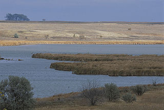
Prairie Pothole is a year-long depressional freshwater wetland lake found in Stutsman County, North Dakota. It is on land that is administered by the USGS and USFWS. It is managed as part of the Chase Lake National Wildlife Refuge.


