
Mission San Fernando Rey de España is a Spanish mission in the Mission Hills community of Los Angeles, California. The mission was founded on 8 September 1797 at the site of Achooykomenga, and was the seventeenth of the twenty-one Spanish missions established in Alta California. Named for Saint Ferdinand, the mission is the namesake of the nearby city of San Fernando and the San Fernando Valley.

The San Fernando Valley, known locally as the Valley, is an urbanized valley in Los Angeles County, California. Situated to the north of the Los Angeles Basin, it contains a large portion of the City of Los Angeles, as well as unincorporated areas and the incorporated cities of Burbank, Calabasas, Glendale, Hidden Hills, and San Fernando. The valley is well known for its iconic film studios such as Warner Bros. Studios and Walt Disney Studios. In addition, it is home to the Universal Studios Hollywood theme park.

Chatsworth is a suburban neighborhood in Los Angeles, California, in the San Fernando Valley.

West Hills is a suburban/residential community in the western San Fernando Valley region of the City of Los Angeles, California. The percentage of residents aged 35 and older is among the highest in Los Angeles County.

Stoney Point, also known as the Stoney Point Outcroppings or Chatsworth Formation, is a Los Angeles City park near the north end of Topanga Canyon Boulevard in Chatsworth, Los Angeles, California, part of the city of Los Angeles. Stoney Point is a popular destination for hikers, equestrians and also with rock climbers because of its large boulders, which afford many opportunities to practice the sport of bouldering. The top of the rock formation offers excellent views of Chatsworth, the Santa Susana Mountains, Coyote Pass, and the entire San Fernando Valley.
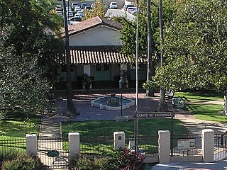
The Campo de Cahuenga, near the historic Cahuenga Pass in present-day Studio City, California, was an adobe ranch house on the Rancho Cahuenga where the Treaty of Cahuenga was signed between Lieutenant Colonel John C. Frémont and General Andrés Pico in 1847, ending hostilities in California between Mexico and the United States. The subsequent Treaty of Guadalupe Hidalgo of 1848, ceding California, parts of Colorado, Nevada, New Mexico, and Arizona to the United States, formally ended the Mexican–American War. From 1858 to 1861 the Campo de Cahuenga became a Butterfield Stage Station.

The San Fernando Valley Historical Society is a private service organization, in Mission Hills, Los Angeles County, California, that is committed to "research, collect and preserve the history, art and culture of the San Fernando Valley". The group was founded on July 4, 1943.

Rancho San Francisco was a land grant in present-day northwestern Los Angeles County and eastern Ventura County, California. It was a grant of 48,612 acres (19,673 ha) by Governor Juan B. Alvarado to Antonio del Valle, a Mexican army officer, in recognition for his service to Alta California. It is not related to the city of San Francisco.

Rancho Los Encinos was a Spanish grazing concession, and later Mexican land granted cattle and sheep rancho and travelers way-station on the El Camino Real in the San Fernando Valley, in present-day Encino, Los Angeles County, California. The original 19th-century adobe and limestone structures and natural Encino Springs are now within the Los Encinos State Historic Park.

Santa Susana Pass State Historic Park is a California State Park of 670.68 acres (2.7141 km2) located in the city of Los Angeles, in Los Angeles County on the boundary between Ventura and Los Angeles counties, between the communities of Chatsworth and Simi Valley. Geologically, the park is located where the Simi Hills meet the Santa Susana Mountains. Here in the western part of the Transverse Ranges, the land is dominated by high, narrow ridges and deep canyons covered with an abundant variety of plant life. The park offers panoramic views of the rugged natural landscape as a striking contrast to the developed communities nearby. The park is also rich in archaeological, historical, and cultural significance.
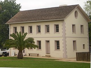
Los Encinos State Historic Park is a state park unit of California, preserving buildings of Rancho Los Encinos. The park is located near the corner of Balboa and Ventura Boulevards in Encino, California, in the San Fernando Valley. The rancho includes the original nine-room de la Ossa Adobe, the two-story limestone Garnier building, a blacksmith shop, a natural spring, and a pond. The 4.7-acre (1.9 ha) site was established as a California state park in 1949.
Rómulo Pico Adobe, also known as Ranchito Rómulo and Andrés Pico Adobe, was built in 1834 and is the oldest residence in the San Fernando Valley, making it the second oldest residence in Los Angeles. Built and owned by the Pico family of California, a prominent Californio family, the adobe is located in the Mission Hills section of the city and is a short distance from the San Fernando Mission. It was listed on the National Register of Historic Places in 1966.

The Old Santa Susana Stage Road, or Santa Susana Wagon Road, is a route taken by early travelers between the San Fernando Valley and Simi Valley near Chatsworth, California, via the Santa Susana Pass. The main route climbs through what is now the Santa Susana Pass State Historic Park, with a branch in Chatsworth Park South.

The Minnie Hill Palmer House, also known as The Homestead Acre, is the only remaining homestead cottage in the San Fernando Valley. The cottage is a redwood Stick-Eastlake style American Craftsman-Bungalow located on a 1.3-acre (0.53 ha) site in Chatsworth Park South in the Chatsworth section of Los Angeles, California.

Chatsworth Community Church is a Los Angeles Historic-Cultural Monument in the Chatsworth section of Los Angeles, California.

The Lassen Street Olive Trees, also known as 76 Mature Olive Trees, are a Los Angeles Historic-Cultural Monument located in the Chatsworth community of the northwestern San Fernando Valley, in Los Angeles, Southern California.

The history of the San Fernando Valley from its exploration by the 1769 Portola expedition to the annexation of much of it by the City of Los Angeles in 1915 is a story of booms and busts, as cattle ranching, sheep ranching, large-scale wheat farming, and fruit orchards flourished and faded. Throughout its history, settlement in the San Fernando Valley was shaped by availability of reliable water supplies and by proximity to the major transportation routes through the surrounding mountains.

The Chatsworth Nature Preserve (CNP) is a 1,325-acre (536 ha) open-space preserve located in the northwest corner of the San Fernando Valley in Los Angeles, California, United States. The preserve contains oak woodlands, savanna, riparian areas, grassland, vernal pools, and an Ecology Pond, all of which support more than 200 bird species and numerous mammals, amphibians and reptiles.

The Mission Vieja or Misión Vieja or the Old Mission was the first Spanish mission in the San Gabriel Valley. Mission Vieja was built in 1771 by what would become the fathers of the Mission San Gabriel Arcángel. The Mission Vieja site was designated a California Historic Landmark (No.161) on Jan. 11, 1935. The location of Mission Vieja is at what is now the South West corner North San Gabriel Blvd and North Lincoln Ave in Montebello, California. The site has a plaque marker and an El Camino Real Bell. Mission Vieja was the first building in the San Gabriel Valley and Los Angeles County. Father Juan Crespí picked the spot for Mission Vieja because water was available at what is now called the Whittier Narrows. The place for Mission Vieja was found in the expedition of Portolá in the summer of 1769. Gaspar de Portolá, Miguel Costansó and Father Juan Crespí recorded the expedition. In 1771 the fathers of Pedro Cambon and the fathers of Angel Somera, with a decree from Governor Pedro Fages, set out to build a mission in the Spanish Empire of Alta California, in what is now called the Los Angeles Basin. The first building was 45 by 18 feet made of adobe and wood. The roof was made with tule reeds from the waters of the Whittier Narrows. The building had around it a weak Palisade fence. Father Angel Somera and Father Pedro Cambon, both Franciscan missionaries, founded Mission Vieja, the original Mission San Gabriel Arcangel, on September 8, 1771; the location is today near the intersection of San Gabriel Boulevard and the Rio Hondo River. The establishment of the mission marked the beginning of the Los Angeles region's settlement by Spaniards and the fourth of twenty-one missions ultimately established along California's El Camino Real. The mission did well initially as a farm and cattle ranch. Six years after its founding, however, a destructive flood in 1776 led the mission fathers to relocate the mission five miles north, to its current location in what is the present day City of San Gabriel.

