Chaugan

Last updated

Jaisinghpur's chaugan Jaisinghpur Chougan.JPG
Jaisinghpur's chaugan

Chaugan is the term used in Himachal for plains. The chaugan of Himachal Pradesh are at Chamba district, Sujanpur, and at Jaisinghpur.

Contents

Chaugan (region)

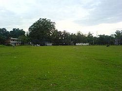
Chaugan, which is located at Sujanpur Tihra, is the largest region in Himachal Pradesh in India. It existed at the time of Raja Sansar Chahd, who was the king of Sujanpur Tihra. The fort of Sansar Chand is located about 1/2 km away from Chaugan.

Chaugan (sport)

In the Middle East, Chaugan is a game similar to Golf and Polo. It involves a ball, horses, and sticks (gili). The word can also mean "four corners". In this sense the word probably refers to the playing ground on which the game is played. Qutb-ud-din Aibak, who was a general at Muhammad Ghori's Delhi Sultanate, died as a result of a fall from his horse while playing Chaugan.

Related Research Articles

<span class="mw-page-title-main">Kangra district</span> District in Himachal Pradesh, India

Kangra district is the most populous district of the Indian state of Himachal Pradesh. Dharamshala is the administrative headquarters of the district.

<span class="mw-page-title-main">Hamirpur district, Himachal Pradesh</span> District of Himachal Pradesh in India

Hamirpur district is in the Indian state of Himachal Pradesh. The headquarters of the district are in the town of Hamirpur. With an area of 1,118 square kilometres or 432 square miles, it is the smallest district of Himachal Pradesh.

<span class="mw-page-title-main">Chamba district</span> District of Himachal Pradesh in India

Chamba district is the northwestern district of Himachal Pradesh, in India, with its headquarters in Chamba town. The towns of Dalhousie, Khajjhiar and Churah Valley are popular hill stations and vacation spots for the people from the plains of northern India.

<span class="mw-page-title-main">Kangra, Himachal Pradesh</span> City in Himachal Pradesh, India

Kangra is a city and a municipal council in Kangra district in the Indian state of Himachal Pradesh. It is also known as Nagarkot.

<span class="mw-page-title-main">Hamirpur, Himachal Pradesh</span> Town in Himachal Pradesh, India

Hamirpur is a Municipal Council and the headquarters of Hamirpur district in the Indian state of Himachal Pradesh. It is covered by Shivalik Ranges. Hamirpur is located in the Lower West Central Outer Himalayas at an average elevation of 790 M above sea level. Far northern High Altitude Dhauladhar Ranges overlook the city. It is also a major junction on National Highway 3 While National Highway 103 starts at Here. Hamirpur is Famous for its High literacy rate, Educational Institutions and Traditional Festival Of Hamir Utsav. Hamirpur City is spread from Jhaniari to Bhota along NH 3 and NH 103 and is a prominent commercial centre for the district. It is Connected to the National Capital with regular HRTC Volvo and ordinary Buses. The nearest Airport is Kangra Airport and Mohali International Airport While the nearest Railway is in Una at 79 km. Hamirpur City is surrounded by Pine tree forests and has a good city infrastructure ranging from Quality Educational Institutions, NIT, State Universities and Skill Learning centres.

Katoch is a Chandravanshi Rajput clan after adopting the process of rajputanisation. Their traditional area of residence was in the Trigarta Kingdom, based at Jalandhar and at Kangra Fort in the Indian state of Himachal Pradesh. They descent from the Trigarta dynasty mentioned in the Mahabharata. Famous subclans came into existence from Katoch Rajputs are Dadwal Dynasty, Guleria Dynasty, Sibaia Dynasty, Chib Dynasty, Jaswal Dynasty.

<span class="mw-page-title-main">Sansar Chand</span>

Sansar Chand was a Rajput ruler of the erstwhile state of Kangra in what is now the Indian state of Himachal Pradesh.

<span class="mw-page-title-main">Kangra Fort</span> Fort in Himachal Padesh, India

The Kangra Fort is located 20 kilometers from the town of Dharamsala on the outskirts of the town of Kangra, in the Kangra district of Himachal Pradesh, India.

<span class="mw-page-title-main">Tira Sujanpur</span> Town in Himachal Pradesh, India

Tira Sujanpur, also known as Sujanpur Tira or Sujanpur Tihra, is a town and municipal council in the Hamirpur district of Himachal Pradesh. Founded in the 18th-century by the Katoch dynasty, the town is located midst the Himalayan foothills on the southern bank of the Beas River. It was one of the centers of Kangra-style miniature paintings and Hindu temples built in an unusual blend of conventional Nagara architecture shrines with Mughal architecture palace, the latter decorated with floral murals of legends from the Ramayana and the Mahabharata.

<span class="mw-page-title-main">Chamba, Himachal Pradesh</span> Town in the Himachal Pradesh, India

Chamba is a town in the Chamba district in the Indian state of Himachal Pradesh. According to the 2001 Indian census, Chamba has a population of 20,312 people. Located at an altitude of 1,006 metres (3,301 ft) above mean sea level, the town is situated on the banks of the Ravi River, at its confluence with the Sal River.

<span class="mw-page-title-main">Prem Kumar Dhumal</span> Indian politician

Prem Kumar Dhumal is an Indian politician and has twice served as the Chief Minister of Himachal Pradesh, from March 1998 to March 2003 and again from 1 January 2008 to 25 December 2012. He was the Bharatiya Janata Party's Chief Ministerial candidate for the 2017 Himachal Assembly Election, in which he lost his seat.

<span class="mw-page-title-main">History of Himachal Pradesh</span>

Himachal Pradesh was established in 1948 as a Chief Commissioner's Province within the Union of India. The province comprised the hill districts around Shimla and southern hill areas of the former Punjab region. Himachal became a part C state on 1951 with the implementation of the Constitution of India. Himachal Pradesh became a Union Territory on 1 November 1956. On 18 December 1970 the State of Himachal Pradesh Act was passed by Parliament and the new state came into being on 25 January 1971. Thus Himachal emerged as the eighteenth state of the Indian Union.

Jaisinghpur is a small town and subdivision in Kangra district of Himachal Pradesh, India. There are two tehsils: the main tehsil is in Jaisinghpur and the sub tehsil is in Alampur. The population of Jaisinghpur Town is 2,602 and the overall population of Jaisinghpur Sub-Division is 58,623. It was named after Katoch, a Rajput king of the Princely estate of Kangra-Lambagraon, Col. His Highness Maharaja Shri Sir Jai Chand Katoch who ruled from 1864 to 1933. It is situated on the bank of river Beas. It is known for its "Chaugan", which is the term used in Himachal Pradesh for a plain. There are several notable temples in the town such as the Janaki Nath temple, the Radhey Krishan temple near Bus Adda, the Laxmi Narayan temple, the Baba Mani Ram Temple, Baba khadesri kutiya, the Neel Kanth Mahadev Temple, the Dhudu Mahadev Mandir temple, the Guga temple, the Shitala Mata temple. There is also a Dargah midtown, popularly known as Baba Shah Mast Ali Dargah, and a Gurudwara on Jaisinghpur Lambagoan road. The Shitala Mata temple is a famous temple of the town on Tinbar-Palampur road. Another famous temple is the Jankinath temple. One of the more notable tourist places is Naguli Naag, which has a swimming pool. Another one is Basanti da Patan near the Beas river where people can go boating.

<span class="mw-page-title-main">Sainik School, Sujanpur Tihra</span> Public school in India

Sainik School Sujanpur Tihra is a Sainik School in the town of Tira Sujanpur, Hamirpur district in the state of Himachal Pradesh, India.

<span class="mw-page-title-main">Urmil Thakur</span> Indian politician

Smt. Urmil Thakur is an Indian politician from Hamirpur, Himachal Pradesh.

The Nepal–Sikh War was a large scale military conflict in 1809 between the forces of the Kingdom of Nepal under Amar Singh Thapa and the Sikh Empire under general Dewan Mokham Chand.

<span class="mw-page-title-main">Sujanpur, Himachal Pradesh Assembly constituency</span> Legislative Assembly constituency in Himachal Pradesh State, India

Sujanpur Assembly constituency is one of the 68 constituencies in the Himachal Pradesh Legislative Assembly of Himachal Pradesh a northern state of India covering Tira Sujanpur. It is part of Hamirpur, Himachal Pradesh Lok Sabha constituency.

<span class="mw-page-title-main">Narbadeshwar Temple</span>

The Narbadeshwar Temple, located in the Sujanpur Tira area of Hamirpur district in India, is dedicated to Lord Shiva.

Sujanpur is a city and municipal council in the Pathankot district of the Indian state of Punjab.

Chabutra Khas better known as Chabutra is a village located in Tira Sujanpur tehsil of Hamirpur district, Himachal Pradesh, India. It is situated 12.4 km away from district headquarter and 11.6 km away from Tehsil Tira Sujanpur. The village is located overlooking Beas river flowing below in the valley. The PIN code of the village is 177007. Chabutra Khas population in 2011 is between 1,051 and 1,201 and total households residing are 237. The village's high School is Government Senior Secondary School, which was founded in 1943.

References