
La Unión is a province of the Arequipa Region in Peru. Its seat is Cotahuasi.
Huallanca or Wallanka is a district of the Bolognesi Province in the Ancash Region of Peru.

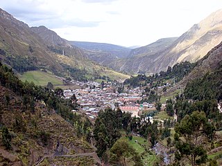
Layo District is one of eight districts in the Canas Province in Peru. The seat of the Layo District is the village Layo.

Canchis Province is one of thirteen provinces in the Cusco Region in the southern highlands of Peru.
Ayapata District is one of ten districts of the province Carabaya in Peru.

Marangani District is one of eight districts of the province Canchis in Peru.
Challabamba District is one of six districts of the Paucartambo Province in Peru.

Chaupi Orco or Viscachani is a mountain in the Andes on the border of Bolivia and Peru. It has a height of 6,044 metres (19,829 ft). On the Bolivian side it is located in the La Paz Department, Franz Tamayo Province, Pelechuco Municipality, and on the Peruvian side it lies in the Puno Region, Putina Province, Sina District. It lies north of Salluyu.
Chawpi Chawpi is a mountain in the Wansu mountain range in the Andes of Peru, about 5,200 metres (17,060 ft) high. It is situated in the Arequipa Region, La Unión Province, Puyca District. Chawpi Chawpi lies northwest of Ikmaqucha and southwest of the mountains Yuraq Punta and Tintaya.
Yuraq Punta is a mountain in the Wansu mountain range in the Andes of Peru, about 5,100 metres (16,732 ft) high. It is located in the Arequipa Region, La Unión Province, Puyca District. Yuraq Punta lies west of Minata, northeast of Chawpi Chawpi and Chunta, and east of Tintaya, north of a lake named Ikmaqucha.

Chawpi Urqu is a 4,617-metre-high (15,148 ft) mountain in the Apolobamba mountain range in Bolivia. It is located in the La Paz Department, Franz Tamayo Province, Pelechuco Municipality, near the Peruvian border. Chawpi Urqu lies east of the mountains Surapata and Kulli Pata and north of Q'umir Pata.
Chaupimaquito is a mountain in the Vilcanota mountain range in the Andes of Peru, about 5,300 metres (17,388 ft) high. It is located in the Cusco Region, Canchis Province, Pitumarca District, east of Sibinacocha. It lies southeast of Condoriquiña and west of Pucasalla.
Chawpi Urqu is a mountain in the Andes of Peru, about 4,400 metres (14,436 ft) high. It is situated in the Ayacucho Region, Cangallo Province, Totos District, northeast of Totos. Chawpi Urqu lies north of Huch'uy Puka Q'asa. The lake east of it is named Llulluchaqucha (Llullucha Ccocha).
Chawpi Urqu may refer to:
Chawpi Hanka is a mountain in the Andes of Peru, about 4,800 m (15,748 ft) high. It is situated in the Ancash Region, Bolognesi Province, in the districts of Huallanca and Huasta, and in the Huánuco Region Lauricocha Province, Queropalca District. It lies on a ridge north of the Waywash mountain range.
Chaupijanca or Chaupi Janca is a 5,283-metre-high (17,333 ft) mountain in the Huallanca mountain range in the Andes of Peru. It is located in the Ancash Region, Bolognesi Province, in the districts of Huallanca and Huasta.
Chawpi Urqu is a mountain in the Bolivian Andes which reaches a height of approximately 4,440 m (14,570 ft). It is located in the Potosí Department, Tomás Frías Province, Yocalla Municipality. It lies northeast of Wichhu Qullu.
Chawpi Urqu is a mountain in the Bolivian Andes which reaches a height of approximately 4,460 m (14,630 ft). It is located in the Potosí Department, Tomás Frías Province, Potosí Municipality. It lies southeast of Jatun Q'asa.
Kuntur Tiyana is a mountain in the Cordillera Central in the Andes of Peru which reaches a height of approximately 4,600 metres (15,092 ft). It is located in the Junín Region, Chupaca Province, Yanacancha District.
Chawpi Punta is a mountain in the Andes of Peru which reaches an altitude of approximately 4,600 m (15,100 ft). It is located in the Ancash Region, Bolognesi Province, Huasta District. Chawpi Punta lies at the Pampa Wayi valley, southwest of Puka Qaqa.


