Related Research Articles

Brooklyn is a borough of New York City. Located on the westernmost end of Long Island, it is coextensive with Kings County in the U.S. state of New York. With 2,736,074 residents as of the 2020 United States census, Kings County is the most populous of the five boroughs of New York City and the most populous county in the State of New York. The population density of Brooklyn was 37,339.9 inhabitants per square mile (14,417.0/km2) in 2022, making it the second-most-densely-populated county in the United States, behind Manhattan, and it had the ninth-highest population of any county nationwide. Were Brooklyn still an independent city, it would be the fourth most populous in the U.S. after the rest of New York City, Los Angeles, and Chicago.

Atlantic County is a county located along the Jersey Shore in the U.S. state of New Jersey. As of the 2020 census, the county was the state's 15th-most-populous county, with a population of 274,534, a drop of 15 from the 2010 census count of 274,549. Its county seat is the Mays Landing section of Hamilton Township. The county is part of the South Jersey region of the state.

Absecon is a city in Atlantic County, in the U.S. state of New Jersey. As of the 2020 United States census, the city's population was 9,137, its highest decennial count ever and an increase of 726 (+8.6%) from the 2010 census count of 8,411, which in turn reflected an increase of 773 (+10.1%) from the 7,638 counted in the 2000 census. The city, and all of Atlantic County, is part of the Atlantic City-Hammonton metropolitan statistical area, which in turn is included in the Philadelphia-Reading-Camden combined statistical area and the Delaware Valley.

Brigantine is a city in Atlantic County in the U.S. state of New Jersey. As of the 2020 United States census, the city's population was 7,716, a decrease of 1,734 (−18.3%) from the 2010 census count of 9,450, which in turn reflected a decline of 3,144 (−25.0%) from the 12,594 counted in the 2000 census. The city, and all of Atlantic County, is part of the Atlantic City-Hammonton metropolitan statistical area, which in turn is included in the Philadelphia-Reading-Camden combined statistical area and the Delaware Valley.

Longport is a borough situated on the Jersey Shore on Absecon Island, within Atlantic County, in the U.S. state of New Jersey, on the Atlantic Ocean shoreline. As of the 2020 United States census, the borough's population was 893, a decrease of two people (−0.2%) from the 2010 census count of 895, which in turn reflected a decline of 159 (−15.1%) from the 1,054 counted in the 2000 census.

Margate City is a city situated on the Jersey Shore on Absecon Island, within Atlantic County, in the U.S. state of New Jersey, on the Atlantic Ocean shoreline. As of the 2020 United States census, the city's population was 5,317, a decrease of 1,037 (−16.3%) from the 2010 census count of 6,354, which in turn had reflected a decline of 1,839 (−22.4%) from the 8,193 counted in the 2000 census. Geographically, the city, and all of Atlantic County, is part of the South Jersey region of the state and of the Atlantic City-Hammonton metropolitan statistical area, which in turn is included in the Philadelphia-Reading-Camden combined statistical area and the Delaware Valley.

Olyphant is a borough in Lackawanna County, Pennsylvania, United States. It is six miles (10 km) northeast of downtown Scranton, on the Lackawanna River in the heart of the anthracite region of the state. Its main source of employment was the mining and shipping of coal. It was the headquarters of the Lackawanna Coal Company. Other industries of the past were the manufacturing of blasting powder, iron and steel goods, cigars, and silks. Olyphant experienced a severe downturn in the 1950s. There was once a thriving garment industry with numerous dress factories in the downtown area. There was also a slaughterhouse. Until 2018, the biggest industry was Cinram the manufacture of compact discs (CD) and digital video discs (DVD). The population was 5,395 at the 2020 census.
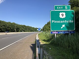
Pleasantville is a city in Atlantic County, in the U.S. state of New Jersey. As of the 2020 United States census, the city's population was 20,629, its highest decennial count ever and an increase of 380 (+1.9%) from the 2010 census count of 20,249, which in turn reflected an increase of 1,237 (+6.5%) from the 19,012 counted in the 2000 census.
Inwood is a neighborhood in the New York City borough of Manhattan, at the northern tip of Manhattan Island, in the U.S. state of New York. It is bounded by the Hudson River to the west, Spuyten Duyvil Creek and Marble Hill to the north, the Harlem River to the east, and Washington Heights to the south.

Washington Heights is a neighborhood in the northern part of the borough of Manhattan in New York City. It is named for Fort Washington, a fortification constructed at the highest natural point on Manhattan by Continental Army troops to defend the area from the British forces during the American Revolutionary War. Washington Heights is bordered by Inwood to the north along Dyckman Street, by Harlem to the south along 155th Street, by the Harlem River and Coogan's Bluff to the east, and by the Hudson River to the west.

Winthrop is a town in Suffolk County, Massachusetts, United States. The population was 19,316 at the 2020 census. Winthrop is an ocean-side suburban community in Greater Boston situated at the north entrance to Boston Harbor, close to Logan International Airport. It is located on a peninsula, 1.6 square miles (4.2 km2) in area, connected to Revere by a narrow isthmus and to multiple portions of Boston by a bridge over the harbor inlet to the Belle Isle Marsh Reservation in the Neighborhood of East Boston, a shared border at the Boston Logan International Airport, and at Deer Island.

Oakwood is a neighborhood located in east central Staten Island, New York City, near the South Shore. It is bordered by Tysens Lane (north); the Atlantic Ocean (east); Great Kills Park (south); Kensico Street, and Clarke Avenue (west).

Pacific Heights is a neighborhood in San Francisco, California, United States. It has panoramic views of the Golden Gate Bridge, San Francisco Bay, the Palace of Fine Arts, Alcatraz, and the Presidio.

Ocean Hill is a subsection of Bedford–Stuyvesant in the New York City borough of Brooklyn. The neighborhood is part of Brooklyn Community Board 16 and was founded in 1890. The ZIP code for the neighborhood is 11233. Ocean Hill's boundaries start from Broadway and the neighborhood of Bushwick in the north, Ralph Avenue and the neighborhoods of Bedford–Stuyvesant proper and Crown Heights to the west, East New York Avenue and the neighborhood of Brownsville to the south, and Van Sinderen Avenue and the neighborhood of East New York to the east.
The Pleasantville Public Schools are a comprehensive community public school district that serves students in pre-kindergarten through twelfth grade from the City of Pleasantville, in Atlantic County, in the U.S. state of New Jersey. The district is one of 31 former Abbott districts statewide that were established pursuant to the decision by the New Jersey Supreme Court in Abbott v. Burke which are now referred to as "SDA Districts" based on the requirement for the state to cover all costs for school building and renovation projects in these districts under the supervision of the New Jersey Schools Development Authority.
Brigantine Island is an island off the Atlantic Ocean coast of New Jersey, located northeast of Atlantic City. It is 6 miles (9.7 km) long. The resort community of Brigantine is located on the island.

The Heights or Jersey City Heights is a neighborhood in Jersey City, New Jersey, located atop the New Jersey Palisades, along the west side of the Hudson River. It is bound by Paterson Plank Road on the north, Highway 139 on the south, Hoboken on the east, and the Hackensack River on the west. and Penhorn Creek on the west. Its postal area ZIP Codes are 07307, and portions of 07306.

Manor Heights is a neighborhood located in Staten Island, New York City. Manor comes from the fact that the neighborhood is adjacent to Manor Road, a major thoroughfare in the North Shore of Staten Island, and Heights due to the area's sudden elevation within its boundaries. The neighborhood's loose boundaries include the areas south of the Staten Island Expressway, north of Brielle Avenue, which is the location of Susan E. Wagner High School, to the west of Manor Road, and to the east of Bradley Avenue.
Absecon Inlet is a narrow strait on the southeastern coast of New Jersey, United States.
Peters Beach or Peter Beach is a former barrier island located on the Jersey Shore of the Atlantic Ocean in Atlantic County, New Jersey, United States. It is now a part of Brigantine Island.
References
- ↑ "District Maps". Dra 2020.
- ↑ Location, Inc. (September 29, 2023). "Chelsea Heights Atlantic City, NJ Neighborhood Profile". Neighborhood Scout. Retrieved September 29, 2023.
- ↑ "Chelsea Heights School / CHS Homepage".