
Maryland is a state in the Mid-Atlantic region of the United States. To its south and west, the state borders Virginia and West Virginia and the national capital of Washington, D.C. To its north, it borders Pennsylvania. To its east, it borders Delaware and the Atlantic Ocean. With a total land area of 12,407 square miles (32,130 km2), Maryland is the ninth-smallest state by land area, and its population of 6,177,224 ranks it the 18th-most populous state and the fifth-most densely populated. Maryland's most populous city is Baltimore, and the capital is Annapolis. Among its occasional nicknames are Old Line State, the Free State, and the Chesapeake Bay State. It is named after Henrietta Maria, the French-born queen of England, Scotland, and Ireland during the 17th century.

Anne Arundel County, also notated as AA or A.A. County, is located in the U.S. state of Maryland. As of the 2020 United States census, its population was 588,261, an increase of just under 10% since 2010. Its county seat is Annapolis, which is also the capital of the state. The county is named for Anne Arundell, Lady Baltimore, a member of the ancient family of Arundells in Cornwall, England, and the wife of Cecilius Calvert, 2nd Baron Baltimore (1605–1675), founder and first lord proprietor of the colony Province of Maryland.

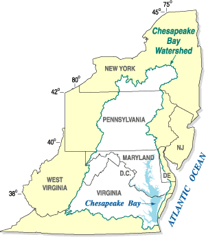
The Chesapeake Bay is the largest estuary in the United States. The Bay is located in the Mid-Atlantic region and is primarily separated from the Atlantic Ocean by the Delmarva Peninsula, including parts of the Eastern Shore of Maryland, the Eastern Shore of Virginia, and the state of Delaware. The mouth of the Bay at its southern point is located between Cape Henry and Cape Charles. With its northern portion in Maryland and the southern part in Virginia, the Chesapeake Bay is a very important feature for the ecology and economy of those two states, as well as others surrounding within its watershed. More than 150 major rivers and streams flow into the Bay's 64,299-square-mile (166,534 km2) drainage basin, which covers parts of six states, New York, Pennsylvania, Delaware, Maryland, Virginia, and West Virginia, and all of Washington, D.C.

The Patuxent River is a tributary of the Chesapeake Bay in the state of Maryland. There are three main river drainages for central Maryland: the Potomac River to the west passing through Washington, D.C., the Patapsco River to the northeast passing through Baltimore, and the Patuxent River between the two. The 908-square-mile (2,352 km2) Patuxent watershed had a rapidly growing population of 590,769 in 2000. It is the largest and longest river entirely within Maryland, and its watershed is the largest completely within the state.

The Monocacy River is a free-flowing left tributary to the Potomac River, which empties into the Atlantic Ocean via the Chesapeake Bay. The river is 58.5 miles (94.1 km) long, with a drainage area of about 970 square miles (2,500 km2). It is the largest Maryland tributary to the Potomac.
The Chesapeake Bay Program is the regional partnership that directs and conducts the restoration of the Chesapeake Bay in the United States. As a partnership, the Chesapeake Bay Program brings together members of various state, federal, academic and local watershed organizations to build and adopt policies that support Chesapeake Bay restoration. By combining the resources and unique strengths of each individual organization, the Chesapeake Bay Program is able to follow a unified plan for restoration. The program office is located in Annapolis, Maryland.
The Chesapeake Bay Foundation (CBF) is a non-profit organization devoted to the restoration and protection of the Chesapeake Bay in the United States. It was founded in 1967 and has headquarters offices in Annapolis, Maryland. The foundation has field offices in Salisbury, Maryland; Harrisburg, Pennsylvania; Richmond, Virginia; Norfolk, Virginia and Washington, D.C.

Conewago Creek is an 80.2-mile-long (129.1 km) tributary of the Susquehanna River in Adams and York counties in Pennsylvania in the United States, with its watershed also draining a small portion of Carroll County, Maryland. The source is at an elevation of 1,440 feet (440 m), east of Caledonia State Park, in Franklin Township in Adams County. The mouth is the confluence with the Susquehanna River at York Haven in York County at an elevation of 259 feet (79 m).
The hickory shad, fall herring, mattowacca, freshwater taylor or bonejack is a member of the herring family Clupeidae, ranging along the East Coast of the United States from Florida to the Gulf of Maine. It is an anadromous fish species, meaning that it spawns in freshwater portions of rivers, but spends most of its life at sea. It is subject to fishing, both historic and current, but it is often confused with or simply grouped together with American shad in catch statistics.

The Mount Vernon Conference was a meeting of delegates from Virginia and Maryland held March 21–28, 1785, to discuss navigational rights in the states' common waterways. On March 28, 1785, the group drew up a thirteen-point proposal to govern the rights of both states on the Potomac River, Pocomoke River, and Chesapeake Bay. Known as the Mount Vernon Compact and formally titled as the Compact of 1785, this agreement not only covered tidewater navigation but also extended to issues such as toll duties, commerce regulations, fishing rights, and debt collection. Ratified by the legislature of both states, the compact helped set a precedent for later meetings between states for discussions into areas of mutual concern.
The Maryland Department of Natural Resources (DNR) is a government agency in the state of Maryland charged with maintaining natural resources including state parks, public lands, state forests, state waterways, wildlife, and recreation areas. Its headquarters are in Annapolis.
The Chesapeake Bay Gateways Network is a partnership program of the National Park Service and a system of over 150 parks, refuges, museums, historic communities and water trails in the Chesapeake Bay watershed. As a partnership program, it is not considered a Unit of the National Park System, but is managed by the National Park Service's Chesapeake Bay Office in Annapolis, Maryland, which also manages the Captain John Smith Chesapeake National Historic Trail and the Star-Spangled Banner National Historic Trail.
The Alliance for the Chesapeake Bay (Alliance) is a regional nonprofit organization that builds and fosters partnerships and consensus to protect and to restore the Chesapeake Bay and its rivers and streams. Their motto is "Together, we can get the job done!".
The U.S. state of Maryland has a varied geography. It has an area of 12,406.68 square miles (32,133.2 km2) and is comparable in overall area with Belgium [11,787 square miles (30,530 km2)]. It is the 42nd largest and 9th smallest state and is closest in size to the state of Hawaii, the next smallest state. The next largest state, its neighbor West Virginia, is almost twice the size of Maryland. Maryland borders Pennsylvania to the north, Delaware to the northeast, the Atlantic Ocean to the east, and to the west and south by West Virginia and Virginia.

The Susquehanna River Basin Commission (SRBC) is a federal-interstate compact commission created by the Susquehanna River Basin Compact (Pub. L. 91-575) between three U.S. states: (Pennsylvania, New York, and Maryland), and the federal government, and signed into law by President Richard Nixon on Christmas Eve 1970 to be effective 30 days later on January 23, 1971.
The following outline is provided as an overview of and topical guide to the U.S. state of Maryland:

The Interstate Commission on the Potomac River Basin (ICPRB) is an agency composed of commissioners representing the federal government, the states of Maryland, Pennsylvania, Virginia, West Virginia, and the District of Columbia. The ICPRB mission is to enhance, protect, and conserve the water and associated land resources of the Potomac River basin and its tributaries through regional and interstate cooperation.

The Maryland Coastal Bays Program (MCBP) is one of the 28 United States National Estuary Programs created in the 1987 Amendments to the Clean Water Act. The program, organized by the United States Environmental Protection Agency, is a non-regulatory federal-state-local collaboration working to restore water quality and conserve the natural resources of the bay system adjacent to Ocean City, Maryland and Assateague Island. The partnership works with municipalities, non-profits, governmental agencies, and businesses; and helps develop, find funding for, and implement projects and programs aimed at improving the health of the estuary. The partnership either directly implements these projects, or administers and manages grants, holds educational workshops and highlights project results.

Blue Plains Advanced Wastewater Treatment Plant in Washington, D.C., is the largest advanced wastewater treatment plant in the world. The facility is operated by the District of Columbia Water and Sewer Authority. The plant opened in 1937 as a primary treatment facility, and advanced treatment capacity was added in the 1970s and 1980s. The effluent that leaves Blue Plains is discharged to the Potomac River and meets some of the most stringent permit limits in the United States.
The Baltimore, Chesapeake and Atlantic railroad, nicknamed Black Cinders & Ashes, ran from Claiborne, Maryland, to Ocean City, Maryland. It operated 87 miles (140.0 km) of center-line track and 15.6 miles (25.11 km) of sidings. Chartered in 1886, the railroad started construction in 1889 and cost $2.356 million ($2024=76,736,000).
