
Derbyshire is a ceremonial county in the East Midlands of England. It borders Greater Manchester, West Yorkshire, and South Yorkshire to the north, Nottinghamshire to the east, Leicestershire to the south-east, Staffordshire to the south and west, and Cheshire to the west. Derby is the largest settlement, and Matlock is the county town.

Chesterfield is a market and industrial town in the ceremonial county of Derbyshire, England. It is 24 miles (39 km) north of Derby and 11 miles (18 km) south of Sheffield at the confluence of the Rivers Rother and Hipper. In 2011, the built-up-area subdivision had a population of 88,483, making it the second-largest settlement in Derbyshire, after Derby. The wider Borough of Chesterfield had a population of 103,569 in the 2021 Census. In 2021, the town itself had a population of 76,402.

Bakewell is a market town and civil parish in the Derbyshire Dales district of Derbyshire, England, known for Bakewell pudding. It lies on the River Wye, 15 miles (23 km) south-west of Sheffield. It is the largest settlement and only town within the boundaries of the Peak District National Park. At the 2011 census, the population of the civil parish was 3,949. It was estimated at 3,695 in 2019. The town is close to the tourist attractions of Chatsworth House and Haddon Hall.

Matlock is the county town of Derbyshire, England. It is in the south-eastern part of the Peak District, with the National Park directly to the west. The spa resort of Matlock Bath is immediately south of the town as well as Cromford lying further south still. The civil parish of Matlock Town had a population in the 2021 UK census of 10,000.

North East Derbyshire is a local government district in Derbyshire, England. The council is based in the large village of Wingerworth. The district also includes the towns of Dronfield and Clay Cross as well as numerous villages and surrounding rural areas.

Dronfield is a town in North East Derbyshire, England, which includes Dronfield Woodhouse and Coal Aston. It lies in the valley of the River Drone between Chesterfield and Sheffield. The Peak District National Park is three miles (4.8 km) to the west. The name comes from the Old English Dranfleld, probably meaning an open land infested with drone bees.

Darley Dale, formerly Darley, is a town and civil parish in the Derbyshire Dales district of Derbyshire, England, with a population of 5,413. It lies north of Matlock, on the River Derwent and the A6 road. The town forms part of a built-up area with both Matlock and Rowsley.

The University of Derby, formerly known as Derby College, is a public university in the city of Derby, England. It traces its history back to the establishment of the Derby Diocesan Institution for the Training of Schoolmistresses in 1851. It gained university status in 1992.

Clay Cross is a town and a civil parish in the North East Derbyshire district of Derbyshire, England. It is a former industrial and mining town, about 5 miles (8.0 km) south of Chesterfield. It is directly on the A61. Surrounding settlements include North Wingfield, Tupton, Pilsley and Ashover.
Peak FM was an Independent Local Radio station serving north Derbyshire. The station was folded into Greatest Hits Radio Yorkshire, as part of a rebrand, on 1 September 2020.

The High Peak Trail is a 17-mile (27 km) trail for walkers, cyclists and horse riders in the Peak District of England. Running from Dowlow (53.2059°N 1.8349°W), near Buxton, to High Peak Junction, Cromford (53.1004°N 1.5354°W), it follows the trackbed of the former Cromford and High Peak Railway, which was completed in 1831 to carry minerals and goods between the Cromford Canal wharf at High Peak Junction and the Peak Forest Canal at Whaley Bridge.

Chesterfield railway station serves the market town of Chesterfield in Derbyshire, England. It lies on the Midland Main Line. Four tracks pass through the station which has three platforms. It is currently operated by East Midlands Railway.

North East Derbyshire is a constituency created in 1885 represented in the House of Commons of the UK Parliament since 2017 by Lee Rowley of the Conservative Party. This was the first time a Conservative candidate had been elected since 1935.
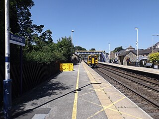
Dronfield railway station serves the town of Dronfield in Derbyshire, England, south of Sheffield, on the Midland Main Line between Chesterfield and Sheffield.
Calow is a village and civil parish in the county of Derbyshire in England. The population of the village at the 2011 census was 2,494. Calow is in North East Derbyshire and is adjacent to Chesterfield.

Saltergate, officially the Recreation Ground, was the historic home of Chesterfield Football Club, and was in use from 1871 until the club's relocation in July 2010, a 139-year history that made it one of the oldest football grounds in England at the time of its closure. From the 1920s onward the name 'Saltergate' became predominant in popular references to the ground.

Chapel-en-le-Frith is a town and civil parish in the Borough of High Peak in Derbyshire, England.
Bolsover Tunnel is a disused and infilled twin-track railway tunnel between Carr Vale and Scarcliffe in Derbyshire, England.
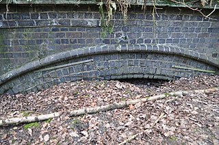
Duckmanton Tunnel is a former 501-yard (458-metre) long twin-track railway tunnel between Chesterfield and Arkwright Town in Derbyshire, England.
Low Pavement is a short street located in Chesterfield, Derbyshire, England. It connects West Bars to Vicar Lane. The street is a shopping district.
