Chesters Hill Fort

Last updated

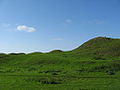
Chesters Hill Fort is an Iron Age hill fort in East Lothian, Scotland. It lies 1 mile (2 kilometres) south of Drem, 1+12 mi (2.5 km) east of Ballencrieff Castle, 2+12 mi (4 km) north of Haddington, and 2 mi (3 km) west of Athelstaneford. The name "Chesters" comes from Latin castra, a fortified place.

Contents

This fortified village with its system of ramparts and ditches around a settlement of about twenty roundhouses is in the care of Historic Environment Scotland, who describe it as "one of the best-preserved examples in Scotland of an Iron age fort". [1]

The hillfort was subject to a detailed programme of survey by Rampart Scotland. [2]

See also

Related Research Articles

<span class="mw-page-title-main">Lammermuir Hills</span> Range of hills in southern Scotland

The Lammermuirs are a range of hills in southern Scotland, forming a natural boundary between East Lothian and the Borders. The name "Lammermuir" comes from the Old English lambra mōr, meaning "moorland of the lambs".

<span class="mw-page-title-main">Traprain Law</span>

Traprain Law is a hill 6 km (4 mi) east of Haddington, East Lothian, Scotland. It is the site of a hill fort or possibly oppidum, which covered at its maximum extent about 16 ha. It is the site of the Traprain Law Treasure, the largest Roman silver hoard from anywhere outside the Roman Empire which included exquisite silver artefacts.

<span class="mw-page-title-main">Hod Hill</span> Hillfort in Dorset, England

Hod Hill is a large hill fort in the Blackmore Vale, 3 miles (5 km) north-west of Blandford Forum, Dorset, England. The fort sits on a 143 m (469 ft) chalk hill of the same name that lies between the adjacent Dorset Downs and Cranborne Chase. The hill fort at Hambledon Hill is just to the north. The name probably comes from Old English "hod", meaning a shelter, though "hod" could also mean "hood", referring to the shape of the hill.

<span class="mw-page-title-main">Old Bewick</span> Human settlement in England

Old Bewick is a rural village and former civil parish, now in the parish of Bewick, in the county of Northumberland, England, notable for its Bronze Age cairn, Iron Age hill fort, 12th-century church; and for cup and ring marked stones – some of the first to be documented in Britain. In 1951 the parish had a population of 82.

<span class="mw-page-title-main">Carl Wark</span> Promontory in Sheffield, England

Carl Wark is a rocky promontory on Hathersage Moor in the Peak District National Park, just inside the boundary of Sheffield, England. The promontory is faced by vertical cliffs on all but one side, which is protected by a prehistoric embankment. The cliffs and embankment form an enclosure that has been interpreted as an Iron Age hill fort, though the date of construction and purpose of the fortifications remains unknown. The site is a scheduled monument.

<span class="mw-page-title-main">Stanwick Iron Age Fortifications</span> Iron Age hill fort in North Yorkshire, England

Stanwick Iron Age Fortifications, a huge Iron Age hill fort, sometimes but not always considered an oppidum, comprising over 9 kilometres (5.6 mi) of ditches and ramparts enclosing approximately 300 hectares of land, are situated in Richmondshire, North Yorkshire, England. Whether Stanwick was the stronghold of Venutius or Cartimandua, or perhaps of them both for a brief time before their acrimonious split some time after 51 AD, it is certain that this settlement was one of the most important in Brigantia, the Brigantes kingdom during the early stages of the Roman occupation of Britain. The site is a scheduled monument.

<span class="mw-page-title-main">Wincobank (hill fort)</span>

Wincobank is an Iron Age hill fort near Wincobank in Sheffield, England.

<span class="mw-page-title-main">Cove, Scottish Borders</span> Village in Scotland

Cove is a village in the Scottish Borders area of Scotland,18 mi (29 km) northwest of the Scotland/England border. It is about 36 miles southeast of Edinburgh and 8 mi (13 km) from Dunbar. Cove is close to Cockburnspath, Dunglass, Innerwick, Oldhamstocks, Bilsdean, and, further afield, Dunbar and Eyemouth. The climate is typical for Scotland, with cold, wet winters and variable summer weather, with days of rain and days of temperatures over 20 °C (68 °F).

Rispain Camp is the remains of a fortified farmstead 1 mile west of Whithorn, Dumfries and Galloway, Scotland. It is one of the major Iron Age archaeological sites in Scotland. The property is in the care of Historic Environment Scotland. Access is through a farm off the A746 South of Whithorn.

<span class="mw-page-title-main">Castle Law</span>

Castle Law is a hill south west of Fairmilehead in the Pentland Hills in Midlothian, Scotland.

Black Castle, East Lothian is an Iron Age hillfort with a number of defensive banks, located 5 kilometres (3.1 mi) south-east of Gifford, East Lothian, Scotland. It is south of the B6355 road, between Darent House and Green Castle hillfort.

<span class="mw-page-title-main">Blackcastle Hill, East Lothian</span>

Blackcastle Hill is an Iron Age hill fort south of Innerwick, East Lothian, Scotland. It is near Cocklaw in the Lammermuir Hills at grid reference NT729724, at a height of 280 metres (920 ft) above sea level. The fort has a single defensive bank.

<span class="mw-page-title-main">Maiden Castle, Cheshire</span> Hillfort in Cheshire, England

Maiden Castle is an Iron Age hill fort, one of many fortified hill-top settlements constructed across Britain during the Iron Age, but one of only seven in the county of Cheshire in northern England. The hill fort was probably occupied from its construction in 600 BC until the Roman conquest of Britain in the 1st century AD. At this time the Cornovii tribe are recorded to have occupied parts of the surrounding area but, because they left no distinctive pottery or metalworking, their occupation has not been verified. Since then it has been quarried and used for military exercises. It is protected as a Scheduled Ancient Monument, and is owned by the National Trust. The hill fort is open to visitors, but unrestricted access to the site has resulted in it being classified as "at high risk" from erosion.

<span class="mw-page-title-main">Eddisbury hill fort</span> Iron Age hillfort in Cheshire, England

Eddisbury hill fort, also known as Castle Ditch, is an Iron Age hill fort near Delamere, Cheshire, in northern England. Hill forts are fortified hill-top settlements constructed across Britain during the Iron Age. Eddisbury is the largest and most complex of the seven hill forts in the county of Cheshire. It was constructed before 200–100 BC and expanded in 1–50 AD. In the 1st century AD, the Romans slighted the site. It was reoccupied in the 6th–8th centuries AD, and an Anglo-Saxon burh was probably established at Eddisbury in 914. In the medieval and post-medieval periods quarrying and farming have damaged the site. Ownership is currently split between the Forestry Commission and a local farm. Eddisbury is protected as a Scheduled Ancient Monument.

<span class="mw-page-title-main">Helsby hill fort</span>

Helsby hill fort is an Iron Age hillfort overlooking the village of Helsby in Cheshire, northwest England. Helsby Hill has steep cliffs on the northern and western sides, providing a natural semicircular defence. Double rampart earthworks extend to the south and east to provide protection to those flanks. Two additional banks have been discovered enclosing a rock ledge on the cliff to the north side. Excavations last century revealed a wall composed of sand and rubble, revetted with stone to the back and front. The hill has a summit of 141 m AOD, and is a prominent landmark rising above the Cheshire Plain, with fine views overlooking the Mersey Estuary and into Wales. Much of the hill is owned and managed by the National Trust. The surrounding areas are well wooded to the southwest, northwest and northeast with farmland to the southeast. The hill fort is protected as a Scheduled Ancient Monument.

<span class="mw-page-title-main">Woodhouse hill fort</span>

Woodhouse hill fort is an Iron Age hillfort between Frodsham and Helsby in Cheshire, England. It lies at the northern end of the Mid Cheshire Ridge. Woodhouse Hill has steep cliffs on the western sides, providing a natural defence. It is defended by a rampart to the north and east where the ground slopes more gently. Excavations in 1951 showed that the rampart was originally 4m high and revetted with stone on both sides. A number of small rounded stones, believed to be slingstones, have been found on the site. The hill fort is protected as a Scheduled Ancient Monument.

<span class="mw-page-title-main">Torr a'Chaisteal</span>

Torr a'Chaisteal is an Iron Age fort (dun), located about 1 mile northeast of the village of Sliddery, on the Isle of Arran in Scotland.

<span class="mw-page-title-main">Kilpatrick Dun</span>

Kilpatrick Dun is an Iron Age dun, located about 1 mile south of the village of Blackwaterfoot on the Isle of Arran in Scotland.

<span class="mw-page-title-main">Torberry Hill</span>

Torberry Hill is an Iron Age hillfort in the county of West Sussex, in southern England. It is a Scheduled Ancient Monument, with a list entry identification number of 1015966. The hill fort is located within the parish of Harting, within the South Downs National Park. The hill includes the remains of an Early Iron Age univallate hill fort, a Middle Iron Age promontory fort and a post-medieval post mill. The hill is a chalk spur projecting northwards from the South Downs.

<span class="mw-page-title-main">Caesar's Camp, Rushmoor and Waverley</span> Iron Age hillfort in Hampshire, England

Caesar's Camp is an Iron Age hill fort straddling the border of the counties of Surrey and Hampshire in southern England. The fort straddles the borough of Waverley in Surrey and the borough of Rushmoor and the district of Hart, both in Hampshire. Caesar's Camp is a Scheduled Ancient Monument with a list entry identification number of 1007895. It lies approximately 3 kilometres (1.9 mi) north of the town of Farnham, and a similar distance west of Aldershot. The hillfort lies entirely within the Bourley and Long Valley Site of Special Scientific Interest. Caesar's Camp is a multivallate hillfort, a fort with multiple defensive rings, occupying an irregular promontory, with an entrance on the south side. The site has been much disturbed by military activity, especially at the southeast corner. The remains of the hillfort are considered to be of national importance.

References

  1. "Historic Scotland - Chesters Hill Fort" . Retrieved 23 November 2014.
  2. "Rampart Scotland - Publications" . Retrieved 23 November 2014.

55°59′36.89″N2°47′26.21″W / 55.9935806°N 2.7906139°W / 55.9935806; -2.7906139