
Dolpo is a high-altitude culturally Tibetan region in the upper part of the Dolpa District of western Nepal, bordered in the north by China. Part of the region lies in Shey Phoksundo National Park. The sparse, agro-pastoral population, known as Dolpo in standard Tibetan and Dhol-wa in the local dialect, is connected to the rest of Nepal via Jufal airport, which can be reached in three days by horse. There are no precise population numbers for the region, with estimates including less than 5,000 and 18,000

Dunai is a village and former Village Development Committee that is now part of Thuli Bheri Municipality in Nepal. Dunai is also the district headquarters of Dolpa District. The town on the banks of the Thuli Bheri River resides at about 2,000 metres (6,562 ft) elevation.
Satungal is a village and former Village Development Committee that is now part of Chandragiri Municipality in Kathmandu District in Province No. 3 of central Nepal. Satungal is also known as Satyapur. At the time of the 1991 Nepal census it had a population of 2,730 people living in 464 households. By the time of the 2001 Nepal census the population had grown to 5,834, spread over 1,375 households. At that time 5,173 of the village population were literate - a literacy rate of 88.7%.
Kaigaun is a village development committee in Dolpa District in the Karnali Zone of north-western Nepal. At the time of the 1991 Nepal census it had a population of 717 persons living in 135 individual households.

Tripurakot is a village development committee in Dolpa District in the Karnali Zone of north-western Nepal. At the time of the 1991 Nepal census it had a population of 1717 persons living in 362 individual households.
Kalika is a village development committee in Dolpa District in the Karnali Zone of north-western Nepal. At the time of the 1991 Nepal census it had a population of 902 persons living in 157 individual households.
Lawan is a village development committee in Dolpa District in the Karnali Zone of north-western Nepal. At the time of the 1991 Nepal census it had a population of 1270 persons living in 279 individual households.
Likhu is a village development committee in Dolpa District in the Karnali Zone of north-western Nepal. At the time of the 1991 Nepal census it had a population of 1465 persons living in 262 individual households.
Mazfal is a village development committee in Dolpa District in the Karnali Zone of north-western Nepal. At the time of the 1991 Nepal census it had a population of 1436 persons living in 274 individual households.
Narku is a village development committee in Dolpa District in the Karnali Zone of north-western Nepal. At the time of the 1991 Nepal census it had a population of 1025 persons living in 194 individual households.
Pahada is a village development committee in Dolpa District in the Karnali Zone of north-western Nepal. At the time of the 1991 Nepal census it had a population of 1413 persons living in 237 individual households.
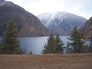
Phoksundo is a village development committee located at the village of Ringmo in the Dolpa District in the Karnali Zone of north-western Nepal. At the time of the 1991 Nepal census it had a population of 457 persons living in 94 individual households.
Raha is a village development committee and municipality in Dolpa District in the Karnali Zone of north-western Nepal. At the time of the 1991 Nepal census it had a population of 511 persons living in 110 individual households.
Rimi is a village development committee in Dolpa District in the Karnali Zone of north-western Nepal. At the time of the 1991 Nepal census, it had a population of 970 persons living in 174 individual households.
Sahartara is a village development committee in Dolpa District in the Karnali Zone of north-western Nepal. At the time of the 1991 Nepal census it had a population of 1511 persons living in 339 individual households.
Tinje is a village development committee in Dolpa District in the Karnali Zone of north-western Nepal. At the time of the 1991 Nepal census it had a population of 1013 persons living in 215 individual households.
Bhalam was a Village Development Committee, north of Pokhara in the Valam Municipality of Kaski District, situated in the Gandaki Zone of the Western Development Region, located in northern-central Nepal. In 2015, the VDC was amalgamated with Pokhara.
Barangja is a village development committee in Myagdi District in the Dhaulagiri Zone of western-central Nepal. At the time of the 1991 Nepal census it had a population of 4576 people living in 891 individual households.
Bhakunde is a village development committee in Baglung District in the Dhawalagiri Zone of central Nepal. At the time of the 1991 Nepal census it had a population of 3,833 and had 697 houses in the village. At the time of the 2011 Nepal census it had a population of 4,952 among which 2,443 were female and 2,509 were male. There were about 831 houses in the village.

