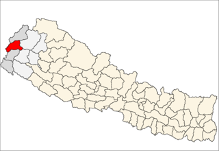
Mahakali is one of the fourteen zones located in the Far-Western Development Region of Nepal, covering an area of 6,205 km2 in the most western part of the country. It stretches along Nepal's far western border with India, marked by the Kali River or Mahakali River, which originates from Limpiyadhura, a disputed location for whether or not the Tri-country border point of Nepal and India with China.
Baitadi District, historical name “Bairath” (बैराथ), a part of Province No. 7, is one of the seventy-Seven districts of Nepal. The district, with Dasharathchand as its headquarters, covers an area of 1,519 km2 and has a population of 250,898 according to the census (2011). The Baitadi district entails 56 village development councils (VDCs) and two municipality. Baitadi falls into the farthest western regional district of Nepal touching Jhulaghat, India, Nepal's neighboring country, to its border.

Dadeldhura district, a part of Province No. 7, is one of the seventy-seven districts of Nepal. The district, with Dadeldhura as its district headquarters, covers an area of 1,538 km² and had a population of 126,162 in 2001 and 142,094 in 2011.

Palpa District (Nepali: पाल्पा जिल्लाListen , a part of Province No. 5, is one of the seventy-seven districts of Nepal, a landlocked country of South Asia. The district, with Tansen Municipality as its headquarters, covers an area of 1,373 km² and has a population of 261,180.

Bheemdatt, is a municipality in far western Nepal. Mahendranagar is a city and the headquarters of the district of Kanchanpur in Mahakali Zone. The city and the municipality was named Mahendranagar in the honour of late king Mahendra of Nepal. After becoming a republic in 2008, the Mahendranagar municipality name was changed to Bheemdatt municipality in honour of the revolutionary farmer leader Bhimdatta Panta, killed in 1953 by Indian forces inside the borders of Nepal.
Birendranagar is a city in Surkhet District in Karnali province of Nepal.

Juropani (जुरोपानी) is a village development committee of the Jhapa district of Nepal.
Melamchi is a municipality in Sindhupalchok District in the Bagmati Zone of central Nepal. At the time of the 1991 Nepal census it had a population of 3936 and had 710 houses in the village.
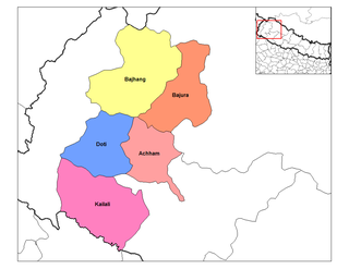
Basantapur is a Village Development Committee in Baitadi District in the Mahakali Zone of western Nepal. At the time of the 1991 Nepal census it had a population of 2,141 and had 366 houses in the village.
Basant pur is a place which is almost 50 kilometres (31 mi) away from the Daimadu. This village is very nice, and people there are very helpful. Many of the people from this village are settled in metro cities of India and in the large cities of the Nepal. Many of the people are settled in Delhi; some of them are businessmen, and a number of youngsters have joined the army in Nepal and are serving their nation. Those who are away from their village they come once in a year and see their native village. Many NGO's are working for the village. The village has its own high school and is having water supply to almost every house. Many festivals like "Gaura", "Dasai" (etc.) are celebrated round the year. The main earning of the people comes from agriculture. The village has many mills for the grinding of wheat. The public transport system is not connected to it, but maybe in the coming years, there will be a transport system of the village.

The Far-Western Development Region was one of Nepal's five development regions. It was located at the western end of the country and had its headquarters in Dipayal.
Kanda is a former village development committee that is now a Rural Municipality in Bajhang District in Province No. 7 of western Nepal. At the time of the 1991 Nepal census it had a population of 1,417 and had 268 houses in the village.
Tokha Chandeshwari is a village and former Village Development Committee that is now part of Tokha Municipality in Kathmandu District in Province No. 3 of central Nepal. At the time of the 2011 Nepal census it had a population of 3961. Tokha Chandeshwari now is part of Tokha municipality.
Tikhatar is a village development committee in Doti District in the Seti Zone of western Nepal. At the time of the 1991 Nepal census it had a population of 5222 people in 958 individual households.

Chhoya छोया is a village placed at approximately 55 km southwest of Dipayal, Doti, Nepal. The altitude of the village is 1294 m (4246 feet) above the mean sea level and geographic locators - 29°15′58″N and 80°46′52″E. The village is located in Jijodamandau VDC of Doti District of Nepal. This is 2 ward of the village development committee. The population of this village is about of 400 individuals residing in 50 individual households. The chhoya is divided into two Mallo and Tallo Chhoya.

Padampur is a municipality in Chitwan District in the Narayani Zone of southern Nepal. At the time of the 1991 Nepal census it had a population of 8884 people living in 1559 individual households.it was transferred in new location named Saguntol by Government of Nepal and completed with in 8 years i.e. from 2050 BS to 2058BS. previously it was at the lap of Rapati river and inside the Chitwan National Park. flood of Rapati river in monsoon season destroy farmers crops. wild animalS also harmed their crops. Transportation, electricity, road and educational facilities were beyond people's access. It was known as one of the remote areas of the Chitwan district. In a view of agriculture, It was the best place for farmers. After the new dawn of democracy in 2046, New government was asked to shift this village for peoples safety and conservation of forest and wild animal. The cabinet of Girija Prasad Koirala was assured to shift in a convenience place soon and started the task immediately. This task was successfully done by the politician Baburam Puri of the Nepali Congress. The late Sailaja Acharya visited the people and understood their griefs and proposed to shift it next to Sagoontol near Jutpani VDC. This was a very difficult task to accomplish successfully .People from the Western Chitwan were stood against it but government took bold decision in favour of people of Padampur. Now it is about 2.5 km east to Bharatpur, district headquarters of Chitwan. Electricity, roads and transportation facility are comparatively better here. 2800 house holds were there now .According to the 2001 census, the total population of the VDC was 11336 with total households 2137. Tharus are the dominant ethnic group with 45.89% of the total VDC population. Brahman, Kshetri, Tamang, Gurung and Newar are other castes here. Mainly banana, maize and oil are farmed here. Except ward no 1 there are deep tubewells to Irrigate farmlands. Poultry, dairy, epiculture, mushroom farming and goat keeping have great potentials here. A campus, A higher secondary school, a secondary boarding school and other 7 primary and lower secondary schools are providing education here. Health post,and Post office are too doing their best for providing services to locals. Drinking water is provided in better and modern way. pipelines of drinking water are available within all roads (113 km) of Padampur. An NGO veterinary office is also serving and helping farmers. Since last 5 years this VDC is starting to be known as one of pocket areas of commercial banana farming of the nation. Nobody is landless here and this is the special feature here. Padampur is very attractive location for migratory view and daily people are migrating here. it is like a colonial place for settlement of people. Government has sifted it in a well planned way and that's why it is the second model VDC of Nepal .Now this village has merged in Kalika Municipality and shares 4 wards in it i.e. kalika -9, kalika-10, kalika-11 and kalika-12.
Letang, "लेटाङ " is a Municipality in Morang District in the Kosi Zone of south-eastern Nepal formed by merging existing Village Development Committees Letang Jante,_Nepal warrangi and Bhogateni. It is a municipality and the urban core of a rapidly growing urban agglomerate in Nepal. It has neighbouring municipalities like Koshi Haraicha, Belbari, Pathari-Sanischare etc.. At the time of the 2011 Nepal census it had a population of 18,552 people living in 4,359 individual households. It is situated at the bank of Chisang River. It is located 46 km North east of Biratnagar 394 km east of Kathmandu, at the northern edge of the Terai plain below the Hills.More than 70% of the people in this VDC are engaged in agriculture. Temples including Rajarani temple, Laxmi Narayan Mandir, Laxmi Panchayan Mandir etc. lies here. The main ethnic groups here are Limbu, Brahmin, Chhetri, Magar, Rai, Tamang etc. The villages including Phadani, Budhabare, Kheruwa, Khaireni, Kirtiman, Kamalpur, Lokhra, Kuinkunda, Biran etc. lies here. Among them Letang Bazaar is most developed and Rajarani has religious and tourism importance being old village in Letang. This Letang Municipality is one of the developed municipality of Morang district with various utilities including drinking water, electricity, communication etc. District-famous schools and campus including Letang Campus, Shanti Bhagawati School Shree Shiksha Vikash M. V. (Kheruwa), Laxmi School, Galaxy Academy, Green Valley School, Minaruwa School, Letang Secondary Boarding School, Bal Niketan School, Pathibhara Boarding School lies here. The town Letang Bazaar is also a part of municipality. Many developmental efforts are active in this area. There is also uneven population distribution in this VDC. Many national politicians, players and film actors such as Babu Bogati, Praween Khatiwada, Ram Bhujel are also from this village. Far more, yearly Rajarani Festival (Mohatshob) is also celebrated by various organizations for its popularity and fame. There is the eastern regional training academy of Nepal Army and also the eastern regional training centre of Agricultural Development Bank, though the bank does not exist nearby.
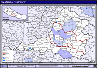
Pindikhola was a village development committee in Syangja District in the Gandaki Zone of central Nepal. At the time of the 2011 Nepal census it had a population of 4,956 people living in 1,119 individual households.
Giruwari is one of the village located in north part of Nawalparasi district of Lumnini Zone in the western development region of Nepal. Lumbinī is a Buddhist pilgrimage site in the Rupandehi district of Nepal.[1] It is the place where Queen Mayadevi gave birth to Siddhartha Gautama, who is the Buddha. Gautama founded the Buddhist tradition. Buddha lived between roughly 563 and 483 BC. Lumbini is one of four magnets for pilgrimage that sprang up in places pivotal to the life of the Buddha, the others being at Kushinagar, Bodh Gaya and Sarnath.

Former administrative units of Nepal are administrative divisions during Kingdom of Nepal. In 2008 Nepal was proclaimed a federal republic and old administrative units restricted after adoption of new constitution on 20 September 2015.