Chhura

Last updated

Chhura is a nagar panchayat located in the Gariaband district (earlier in Raipur district) of Chhattisgarh state of India. [1]

Gariaband district District of Chhattisgarh in India

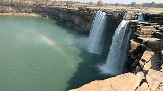
Gariaband District is one of the nine new districts formed in Chhattisgarh, operational from January 1, 2012, ceremonially launched by Chief Minister Dr. Raman Singh on January 11, 2012. Gariaband district was carved out of Raipur district and has its headquarters at Gariaband town. Dhamtari and Mahasamund are the neighbour district. The district covers an area of 5822.861 sq km. is full of natural resources. "Pairy" [1] and "Sodhur" river flows north from here and makes "Triveni Sangam" Rajim together. By building Orissa state border flows "Tel River". Rajim is a famous pilgrimage center of the district, which is also called robert. Every year a "Kumbh Mela" is held from Magh Purnima to Maha Shivaratri. The district is divided into geographical area of the five talukas Gariaband, Chhura, Mainpur, Devbhog and Rajim, respectively. The Gariaband, Chhura and Mainpur blocks are Multiplicity of Tribals. There is four urban bodies in the district in which one Municipality(Gariaband) and three Nagar Panchayat. The area of "Gariaband Forest" is 1951.861 sq km and "Udanti Sita Nadi Tiger Reserve" covers 983.94 sq km. The Gariaband district starts at the ancient temples of Rajim. Being a plan area Figenshwar development block is an irrigated and equipped with modern agriculture methods. Chhura block has created his name as famous tourist places such as "Jatmayi" and "Ghatarani. Baruka Aniket, Tonhidabri, Ramaipot including Rasela near to Malaygiri mountain of Orissa border are forest and plain area. Gariaband block has rich in resources such as Saal and Teak including forest area from the confluence of the Parry and Sodhur river making Dhamtari border. The present collector of Gariyaban is Shruti Singh.

Raipur district District of Chhattisgarh in India

Raipur district is a district in the Chhattisgarh state of India. Raipur is the administrative headquarters of the district. The district is rich in mineral resources. There are many wild life sanctuaries and sight seeing places worth visiting. The district has the population of 30 lakhs.

Chhattisgarh Central-east state in India

Chhattisgarh is one of the 29 states of India, located in the centre-east of the country. It is the tenth-largest state in India, with an area of 135,191 km2 (52,198 sq mi). With a 2011 population of 25.5 million, Chhattisgarh is the 16th-most populated state in the country. A resource-rich state, it is a source of electricity and steel for the country, accounting for 15% of the total steel produced. Chhattisgarh is one of the fastest-developing states in India.

Omkar Shah, member of Chhattisgarh Vidhan Sabha belongs to this village.

Omkar Shah is an Indian politician who was the member of Chhattisgarh Legislative Assembly from Bindranawagarh Assembly constituency then Raipur district,, during 2003-2008. He resides at Village and Post - Chhura in Gariaband district.

Related Research Articles

Korea State

Korea State, currently spelled as Koriya, was a princely state of the British Empire of India. After Indian independence in 1947, the ruler of Korea acceded to the Union of India on 1 January 1948, and Koriya was made part of Surguja District of Central Provinces and Berar province. In January 1950, “Central Provinces and Berar” province was renamed Madhya Pradesh state. After November 2000, Korea and the former princely state of Changbhakar became Koriya district of Chhattisgarh state.

Sokoľ municipality of Slovakia

Sokoľ is a village and municipality in Košice-okolie District in the Kosice Region of eastern Slovakia.

Mahasamund district District of Chhattisgarh in India

Mahasamund District is an administrative district in Chhattisgarh state in eastern India. The city of Mahasamund is the district headquarters. Mahasamund District is bounded by Raipur District - Gariyaband District - Baloda Bazar District -Raigarh District of Chhattisgarh state and Bargarh District and Nuapada District of Odisa state.

Chhattisgarh Division

Chhattisgarh Division was a former administrative division of the Central Provinces of British India. It was located in the east of the Central Provinces and encompassed the upper Mahanadi River basin, in the central part of present-day Chhattisgarh state of India.

Changbhakar former country

Changbhakar State, also known as Chang Bhakar, was one of the princely states of British Empire in India in the Chhattisgarh States Agency. It included 117 villages and had an area of 2,330 square kilometres (899 sq mi) with a 1941 population of 21,266 people. Bharatpur was the capital of the princely state.

Popowlany Village in Podlaskie, Poland

Popowlany is a village in the administrative district of Gmina Tykocin, within Białystok County, Podlaskie Voivodeship, in north-eastern Poland. It lies approximately 4 kilometres (2 mi) north-east of Tykocin and 26 km (16 mi) north-west of the regional capital Białystok.

Reducz Village in Łódź, Poland

Reducz is a village in the administrative district of Gmina Łęki Szlacheckie, within Piotrków County, Łódź Voivodeship, in central Poland. It lies approximately 4 kilometres (2 mi) north of Łęki Szlacheckie, 23 km (14 mi) south-east of Piotrków Trybunalski, and 68 km (42 mi) south of the regional capital Łódź.

Bojańczyce Village in Lesser Poland, Poland

Bojańczyce is a village in the administrative district of Gmina Raciechowice, within Myślenice County, Lesser Poland Voivodeship, in southern Poland. It lies approximately 8 kilometres (5 mi) south-east of Raciechowice, 21 km (13 mi) east of Myślenice, and 34 km (21 mi) south-east of the regional capital Kraków.

Kalina, Masovian Voivodeship Village in Masovian, Poland

Kalina is a village in the administrative district of Gmina Warka, within Grójec County, Masovian Voivodeship, in east-central Poland. It lies approximately 4 kilometres (2 mi) north of Warka, 25 km (16 mi) east of Grójec, and 47 km (29 mi) south of Warsaw.

Piotrkówek Duży Village in Masovian, Poland

Piotrkówek Duży is a village in the administrative district of Gmina Ożarów Mazowiecki, within Warsaw West County, Masovian Voivodeship, in east-central Poland. It lies approximately 2 kilometres (1 mi) east of Ożarów Mazowiecki and 13 km (8 mi) west of Warsaw.

Aşırallar is a village and municipality in the Tovuz Rayon of Azerbaijan. It has a population of 217.

Ciążeń Village in Greater Poland, Poland

Ciążeń is a village in the administrative district of Gmina Lądek, within Słupca County, Greater Poland Voivodeship, in west-central Poland. It lies approximately 10 kilometres (6 mi) south of Słupca and 65 km (40 mi) east of the regional capital Poznań.

Jonk River is a tributary of Mahanadi River that flows for approximately 210 kilometers through the Nuapada District and Bargarh District in the state of Odisha; and the Mahasamund District and Raipur District in the state of Chhattisgarh in India. The river starts from the Sundabeda plateau and enters Maraguda valley where it is joined by a stream called Gaidhas-nala near Patora village. The river forms Beniadhas fall (80 feet) and Kharaldhas fall (150 feet) before entering the valley. It joins Mahanadi at Sheorinarayan.

Sondur River is a tributary of Mahanadi and located in Chhattisgarh, India. Sondur dam is built across this river near Gram Machka in Dhamtari district. The river flows through Sitandi sanctuary before merging with Mahanadi.

Voznice Municipality and village in Central Bohemian Region, Czech Republic

Voznice is a village and municipality in Příbram District in the Central Bohemian Region of the Czech Republic.

Teenuse is a village in Märjamaa Parish, Rapla County in western Estonia.

Aded is a village in the central state of Chhattisgarh, India. It is located in the Bijapur taluk of Bijapur district.

References

  1. "Chhura village" . Retrieved 24 October 2015.

Coordinates: 20°49′N82°13′E / 20.817°N 82.217°E / 20.817; 82.217

Geographic coordinate system Coordinate system

A geographic coordinate system is a coordinate system that enables every location on Earth to be specified by a set of numbers, letters or symbols. The coordinates are often chosen such that one of the numbers represents a vertical position and two or three of the numbers represent a horizontal position; alternatively, a geographic position may be expressed in a combined three-dimensional Cartesian vector. A common choice of coordinates is latitude, longitude and elevation. To specify a location on a plane requires a map projection.