
Chicken Boy is a statue located on North Figueroa Street in the Highland Park district of Los Angeles. The 22-foot tall fiberglass statue was recognized by Governor Arnold Schwarzenegger with the Governor's Historic Preservation Award in 2010. [1]
Chicken Boy is a statue located on North Figueroa Street in the Highland Park district of Los Angeles. The 22-foot tall fiberglass statue was recognized by Governor Arnold Schwarzenegger with the Governor's Historic Preservation Award in 2010. [1]

The statue was originally built in the 1960s for the Chicken Boy Fried Chicken Restaurant, which was located in Downtown Los Angeles on Broadway between 4th and 5th streets, near the Grand Central Market. At that time, International Fiberglass Company of Venice was manufacturing roadside Paul Bunyan and Muffler Man statues for use as outdoor advertising. The Chicken Boy restaurant bought one and hired an artist to customize it. A chicken head was fabricated to replace the man's head. The arms were re-worked to face forward and hold a bucket, rather than an axe. The statue remained in place until 1984 when the restaurant owner died. The statue was eventually given to artist Amy Inouye. She stored it [2] until 2007, when she moved the Chicken Boy statue to its current location at 5558 North Figueroa Street. [3] Her design firm, Future Studio, had relocated to a commercial space that had a reinforced roof strong enough to support the statue. The Chicken Boy statue was preserved as a result of community effort and donated funds.
Eagle Rock is a neighborhood of Northeast Los Angeles, abutting the San Rafael Hills in Los Angeles County, California. The community is named after Eagle Rock, a large boulder whose shadow resembles an eagle. Eagle Rock was once part of the Rancho San Rafael under Spanish and Mexican governorship. In 1911, Eagle Rock was incorporated as a city, and in 1923 it was annexed by Los Angeles.

Chinatown is a neighborhood in Downtown Los Angeles, California, that became a commercial center for Chinese and other Asian businesses in Central Los Angeles in 1938. The area includes restaurants, shops, and art galleries, but also has a residential neighborhood with a low-income, aging population of about 7,800 residents.

Route 110, consisting of State Route 110 (SR 110) and Interstate 110 (I-110), is a state and auxiliary Interstate Highway in the Los Angeles metropolitan area of the US state of California. The entire route connects San Pedro and the Port of Los Angeles with Downtown Los Angeles and Pasadena. The southern segment from San Pedro to I-10 in downtown Los Angeles is signed as I-110, while the northern segment to Pasadena is signed as SR 110. The entire length of I-110, as well as SR 110 south of the Four Level Interchange with US Route 101 (US 101), is the Harbor Freeway, and SR 110 north from US 101 to Pasadena is the historic Arroyo Seco Parkway, the first freeway in the western United States.

Highland Park is a neighborhood in Los Angeles, California, located in the city's Northeast region. It was one of the first subdivisions of Los Angeles and is inhabited by a variety of ethnic and socioeconomic groups.

Jefferson Park is a neighborhood in the South Los Angeles region of the City of Los Angeles, California. There are fourteen Los Angeles Historic-Cultural Monuments in the neighborhood, and in 1987, the 1923 Spanish Colonial Revival Jefferson Branch Library was added to the National Register of Historic Places. A portion of the neighborhood is a designated Historic Preservation Overlay Zone (HPOZ).

Figueroa Street is a major north-south street in Los Angeles County, California, spanning from the Los Angeles neighborhood of Wilmington north to Eagle Rock. A short, unconnected continuation of Figueroa Street runs just south of Marengo Drive in Glendale to Chevy Chase Drive in La Cañada Flintridge.

Zankou Chicken is a small, family-owned chain of Armenian and Mediterranean fast casual restaurants located in the Los Angeles area. The restaurants are especially known for their spit-roasted chicken, shawarma, falafel, tahini, and a "secret" garlic sauce.

Cypress Park is a densely populated neighborhood of 10,000+ residents in Northeast Los Angeles, California. Surrounded by hills on three sides, it sits in the valley created by the Los Angeles River and the Arroyo Seco. It is the site of the Rio de Los Angeles State Park, the Los Angeles River Bike Path and other recreational facilities. It hosts one private and four public schools.
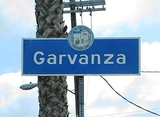
Garvanza is a neighborhood in northeast Los Angeles. Fourteen Los Angeles Historic-Cultural Monuments are located in the neighborhood.
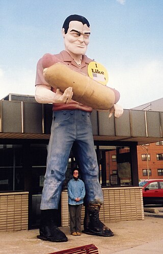
Muffler men are large molded fiberglass sculptures that are placed as advertising icons, roadside attractions, or for decorative purposes, predominantly in the United States. Standing approximately 18–25 ft (5.5–7.6 m) tall, the first figure was a Paul Bunyan character designed to hold an axe. Derivatives of that figure were widely used to hold full-sized car mufflers, tires, or other items promoting various roadside businesses.

The California Governor's Mansion is the official residence of the governor of California, located in Sacramento, the capital of California. Built in 1877, the estate was purchased by the Californian government in 1903 and has served as the executive residence for 14 governors. The mansion was occupied by governors between 1903–1967 and 2015–2019. Since 1967, the mansion has been managed by California State Parks as the Governor's Mansion State Historic Park.

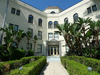
The Highland Park Masonic Temple, also known as The Mason Building or The Highlands, is a historic three-story brick building on Figueroa Street in the Highland Park district of northeast Los Angeles, California.

Annandale is a former community in Los Angeles County, California that is now a neighborhood in Los Angeles, California and Pasadena, California. The Pasadena portion is bordered by Colorado Boulevard to the north, San Rafael Avenue to the east, and the Pasadena-Los Angeles border to the south and west. The Los Angeles portion is approximately bordered by Meridian Street, Figueroa Street, Colorado Blvd and the Pasadena-Los Angeles border. The main roads through the neighborhood are Figueroa Street, Avenue 64 and La Loma Road.
The Los Angeles Avenues refer to a series of 50 numbered streets in Los Angeles, California in the Northeast and Eastside regions. They are all designated with the word "Avenue" followed by a number such as "Avenue 64." The Avenues are located in the Los Angeles neighborhoods of Lincoln Heights, Cypress Park, Montecito Heights, Glassell Park, Highland Park, Mt. Washington and Eagle Rock. They are not related to 2nd through 13th Avenues west of Arlington Avenue in Jefferson Park and other neighborhoods in South Los Angeles.

The Original Pantry Cafe is a coffee shop and restaurant in Los Angeles, California. Located at the corner of 9th and Figueroa in Downtown L.A.'s South Park district, The Pantry claims to never have closed or been without a customer since it opened including when it changed locations in 1950 to make room for a freeway off-ramp; it served lunch in the original location and served dinner at the new location the same day. This claim is also attributed to the fact that Dewey Logan never refused a customer even if the customer was short on money. It was however, closed briefly at the order of health inspectors on November 26, 1997, and reopened the next day. That tradition ended due to the COVID-19 pandemic in California, and the restaurant has since been open from 7 am to either 3 or 5 pm, depending on the day. The restaurant was owned by former Los Angeles mayor Richard Riordan and has served many celebrities and politicians.

Koning Eizenberg Architecture (KEA) is an architecture firm located in Santa Monica, California established in 1981. The firm is recognized for a range of project types including: adaptive reuse of historic buildings, educational facilities, community places, and housing. Principals Hank Koning, Julie Eizenberg, Brian Lane, and Nathan Bishop work collaboratively with developers, cities and not-for-profit clients. Their work has been published extensively both in the US and abroad, and has earned over 200 awards for design, sustainability and historic preservation.
Academia Avance Charter (AA) is a public charter middle and high school in the Highland Park neighborhood of Los Angeles, California, approximately seven miles northeast of downtown. It is part of the Los Angeles County Board of Education and chartered through the California State Board of Education.