
The State of Mexico, officially just Mexico, is one of the 32 federal entities of the United Mexican States. Commonly known as Edomex to distinguish it from the name of the whole country, it is the most populous, as well as the most densely populated, state in the country.
Zacazonapan is a municipality near Mexico City. It's municipal seat is the village of Zacazonapan. The name comes from Nahuatl and roughly translates to "in the River of the Dry Corn plants"
Platón Sánchez is one of the 212 municipalities of the Mexican state of Veracruz. It is located in the state's Huasteca Alta region. The municipal seat is the town of Platón Sánchez.
Tultitlán de Mariano Escobedo is the fourth largest town in and municipal seat of the municipality of Tultitlán located in the northeastern part of the State of México in Mexico. It lies adjacent to the northern tip of the Federal District and is part of the Greater Mexico City urban area. Both the city and the municipality are interchangeably known as San Antonio Tultitlán or simply Tultitlán, a name which comes from Náhuatl meaning "among the tule plants". "de Mariano Escobedo" was added to the city's name in 1902 in honor of the general who fought in the Mexican–American War and for the liberals during the period of La Reforma with Benito Juárez.
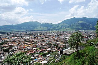
The municipality of Tenango del Valle is located in the southern portion of the Valley of Toluca in Mexico State, about 72 km southwest of Mexico City and 25 km south of Toluca. The municipal seat is the city of Tenango de Arista. While the seat is officially named Tenango de Arista, it is more commonly referred to as Tenango del Valle, as this was the original name of the town. Tenango del Valle is best known as the site of the Teotenango archeological site, which was a walled city inhabited from about 900 C.E. to 1550 C.E.
Chapa de Mota is one of 125 municipalities located in the northwest of Mexico State. The municipal seat is the village of Chapa de Mota and largest town is San Felipe Coamango. It is located in the north part of the State of Mexico. By car, it is two hours from Mexico City.
Santo Tomás de los Plátanos also known as Nuevo Santo Tomás de los Plátanos is a town and municipal seat of the municipality of Santo Tomás, located in the center-west of Mexico State, in Mexico. It is approximately 185 km from Mexico City, and 107 km from Toluca.

Jilotepec de Molina Enríquez, known as Jilotepec de Abasolo until 1986, and commonly known as Jilotepec, is a city located in the northwest zone of the State of Mexico in Mexico. The name comes from Náhuatl, meaning "hill of corncobs". It is the municipal seat and largest city of the municipality of Jilotepec. It is located in hilly and forested terrain about an hour's drive from Mexico City and the state capital of Toluca, 40 minutes from San Juan del Río, 30 minutes from Tula and 20 minutes from Tepeji. The Mexico City–Querétaro highway and the new Transoceanic Freeways that unite the coasts of Mexico from Veracruz to Michoacán converge within its territory.
Chalma Municipality is a municipality in the Mexican state of Veracruz.
Chiconamel Municipality is a municipality in the Mexican state of Veracruz. It is located in the state's Huasteca Alta region. The municipal seat is the village of Chiconamel, Veracruz.
El Higo is one of the 212 municipalities of the Mexican state of Veracruz. It is located in the state's Huasteca Alta region. The municipal seat is the village of El Higo, Veracruz.
Ozuluama de Mascareñas Municipality is one of the 212 municipalities of the Mexican state of Veracruz. It is located in the state's Huasteca Alta region, on the west shore of Tamiahua Lagoon. The municipal seat is the village of Ozuluama de Mascareñas, Veracruz.
Benito Juárez is a municipality in the Mexican state of Veracruz. It is located in the state's Huasteca Baja region. The municipal seat is the village of Benito Juárez, Veracruz.
Indé is the municipal seat of the municipality of Indé in the Mexican state of Durango. As of 2010, the town had a population of 659.
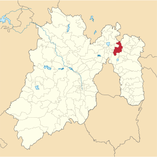
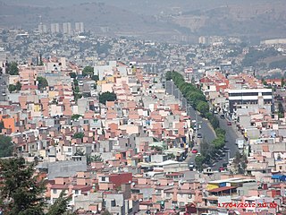
Tecámac is a municipality in State of Mexico in Mexico. The municipality covers an area of 157.34 km². The municipal seat lies in the town (locality) of Tecámac de Felipe Villanueva. Its largest town, Ojo de Agua, with a population of 242,283 inhabitants, is the largest locality in Mexico that is not a municipal seat.

Villa del Carbón is a municipality located in the northern part of Mexico State, just northwest of Mexico City. While the town and municipal seat of Villa del Carbón is the largest in the municipality, it is not the oldest. The municipality contains a number of villages of Otomí and Nahua origins, in which much of the indigenous culture still survives. The municipality's territory was defined in 1714 when a region known as Chiapan, split into what is now Chapa de Mota and Villa del Carbón. At that time, however, the community which is now a municipal seat did not have an official name; it was known first only by the name of its church Nuestra Señora de la Peña de Francia, and later by being a major supplier of charcoal. This would lead to the name of Villanueva del Carbón de Nuestra Señora Santa María de la Peña de Francia, which eventually shortened to Villa del Carbón. The major portions of the municipality's glyph, which serves as it coat-of-arms, does not reflect the town of Villa del Carbón but rather two of its oldest communities: Taxhimay and San Lorenzo Pueblo Nuevo.

Honey is a town and municipality in the Sierra Norte region of the Mexican state of Puebla, on the border with the state of Hidalgo. It serves as the seat of the surrounding municipality of the same name.
Cumpas Municipality is a municipality in the Mexican state of Sonora in north-western Mexico.
Nácori Chico Municipality is a municipality in the Mexican state of Sonora in north-western Mexico.
San Martín Chalchicuautla is a town and municipality in the Mexican state of San Luis Potosí in central Mexico.
