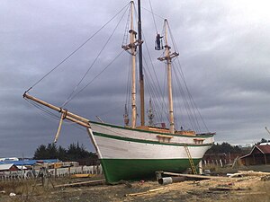
The fourth USS Enterprise was a United States Navy schooner.

The Magallanes Region, officially the Magallanes y la Antártica Chilena Region, is one of Chile's 16 first order administrative divisions. It is the southernmost, largest, and second least populated region of Chile. It comprises four provinces: Última Esperanza, Magallanes, Tierra del Fuego, and Antártica Chilena.

The Strait of Magellan, also called the Straits of Magellan, is a navigable sea route in southern Chile separating mainland South America to the north and Tierra del Fuego to the south. The strait is considered the most important natural passage between the Atlantic and Pacific oceans. The strait is approximately 570 km long and 2 km wide at its narrowest point. In 1520, the Spanish expedition of the Portuguese navigator Ferdinand Magellan, after whom the strait is named, became the first Europeans to discover it.
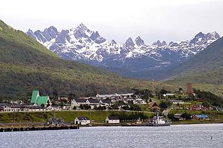
Puerto Williams is a city, port and naval base on Navarino Island in Chile, and is also the southernmost populated settlement in the world. It faces the Beagle Channel. It is the capital of the Chilean Antarctic Province, one of four provinces in the Magellan and Chilean Antarctica Region, and administers the communes of Chilean Antarctic Territory and Cabo de Hornos. It has a population of 2,874, including both naval personnel and civilians. Puerto Williams claims the title of world's southernmost city. The settlement was founded in 1953, and was first named Puerto Luisa. The town was later named after John Williams Wilson, a British man who founded Fuerte Bulnes, the first settlement in the Strait of Magellan. It has served primarily as a naval base for Chile. The Chilean Navy runs the Guardiamarina Zañartu Airport and hospital, as well as nearby meteorological stations. Since the late 20th century, the number of navy personnel has decreased in Puerto Williams and the civilian population has increased. In that period, tourism and support of scientific research have contributed to an increase in economic activity.

Ciudad del Rey Don Felipe, also known as Puerto del Hambre, is a historic settlement site at Buena Bay on the north shore of the Strait of Magellan approximately 58 km (36 mi) south of Punta Arenas in the Región de Magallanes y la Antártica Chilena, Patagonia, Chile.
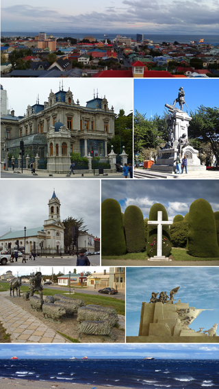
Punta Arenas is the capital city of Chile's southernmost region, Magallanes and Antarctica Chilena. Although officially renamed as Magallanes in 1927, the name was changed back to Punta Arenas in 1938. The city is the largest south of the 46th parallel south and the most populous southernmost city in Chile and the Americas. Due to its location, it is also the coldest coastal city with more than 100,000 inhabitants in Latin America. Punta Arenas is one of the world's most southerly ports and serves as an Antarctic gateway city. Punta Arenas is the world's southernmost city with more than 100,000 inhabitants and claims the title of southernmost city in the world, although this title is also claimed by Ushuaia in Argentina, which lies farther south but is slightly smaller than Punta Arenas.

Mount Tarn is a small mountain located on the southernmost part of the Strait of Magellan, in Brunswick Peninsula, about 70 km south of Punta Arenas, Chile. It is in the southern extreme of continental Chile very close to Cape Froward, surrounded by historic places such as Fort Bulnes and Puerto del Hambre.

Magallanes Province is one of four provinces in the southern Chilean region of Magallanes and Antártica Chilena. The provincial capital is the city of Punta Arenas.

Fuerte Bulnes is a Chilean fort located by the Strait of Magellan, 62 km south of Punta Arenas. It was founded in 1843 on a rocky hill at Punta Santa Ana, and named after President Manuel Bulnes Prieto.

Bernhard Eunom Philippi was a German naturalist, explorer and colonization agent for Chile. He played an important role in the Chilean colonization of the Strait of Magellan and the German colonization of Valdivia, Osorno and Llanquihue.
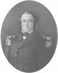
John Williams Wilson (1798–1857), also known as Juan Guillermos, was an English-Chilean sailor and politician. Born in Bristol, he entered the newly founded Chilean navy in 1824 and rose to the rank of commander. He was appointed governor of Talcahuano (1849–1855). He supervised construction of Fuerte Bulnes in 1843, which the government intended for a settlement at the Strait of Magellan. Puerto Williams, founded in 1953, was named for the naval commander.
The southern coast of Chile presents a large number of fjords and fjord-like channels from the latitudes of Cape Horn to Reloncaví Estuary. Some fjords and channels are important navigable channels providing access to ports like Punta Arenas, Puerto Chacabuco and Puerto Natales.

The Nao Victoria Museum is a private maritime museum located in Punta Arenas, Chile. It has been open to the public since 1 October 2011. The museum offers interactive displays featuring replicas of the ships that contributed to the discovery of the area, helped colonize the territory, or had a special and historic heritage significance for the Magallanes Region of Chile. The replicas were built using traditional shipbuilding techniques.
In late 19th and early 20th centuries, sheep farming expanded across the Patagonian grasslands making the southern regions of Argentina and Chile one of the world's foremost sheep farming areas. The sheep farming boom attracted thousands of immigrants from Chiloé and Europe to southern Patagonia. Early sheep farming in Patagonia was oriented towards wool production but changed over time with the development of industrial refrigerators towards meat export. Besides altering the demographic and economic outlook of Southern Patagonia the sheep farming boom also changed the steppe ecosystem.

Isabel Island is an island in the Strait of Magellan. It is located near the western shores of the Strait about 3.5 km east of the narrowest part of Brunswick Peninsula. The island is famous for being the place where large-scale sheepherding was first practiced in Southern Patagonia.
In Colonial times the Spanish Empire diverted significant resources to fortify the Chilean coast as consequence of Dutch and English raids. The Spanish attempts to block the entrance of foreign ships to the eastern Pacific proved fruitless due to the failure to settle the Strait of Magellan and the discovery of the Drake Passage. As result of this the Spanish settlement at Chiloé Archipelago became a centre from where the west coast of Patagonia was protected from foreign powers. In face of the international wars that involved the Spanish Empire in the second half of the 18th century the Crown was unable to directly protect peripheral colonies like Chile leading to local government and militias assuming the increased responsibilities.
Puerto Americano is a natural harbour in the fjords and channels of Patagonia. The harbour lies southwest of Tangbac Island near where the west-east Nihualac Channel meets the north-south Moraleda Channel in Aysén Region.
The Chilean takeover of the Strait of Magellan began in 1843 when an expedition founded Fuerte Bulnes. In 1848 the settlement of Punta Arenas was established further north in the strait and grew eventually to become the main settlement in the strait, a position it holds to this day. The Chilean settlement of the strait was crucial to establish its sovereignty claims in the area. Argentina complained diplomatically this act in 1847, as part of the East Patagonia, Tierra del Fuego and Strait of Magellan Dispute, and once the dispute was settled, formally recognised Chilean sovereignty of the strait in 1881. The Magallanes territory was made a regular Chilean province in 1928.
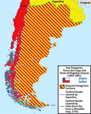
The East Patagonia, Tierra del Fuego and Strait of Magellan Dispute or the Patagonia Question was the boundary dispute between Argentina and Chile during the 19th century for the possession of the southernmost territories of South America on the basis of disagreements over the boundaries corresponding to the uti possidetis juris inherited from the Spanish Empire.