
Coimbatore district is one of the 38 districts in the state of Tamil Nadu in India. Coimbatore is the administrative headquarters of the district. It is one of the most industrialized districts and a major textile, industrial, commercial, educational, information technology, healthcare and manufacturing hub of Tamil Nadu. The region is bounded by Tiruppur district in the east, Nilgiris district in the north, Erode district in the north-east, Palakkad district, Idukki district and small parts of Thrissur district and Ernakulam district of neighboring state of Kerala in the west and south respectively. As of 2011, Coimbatore district had a population of 3,458,045 with a sex-ratio of 1,000 and literacy rate of 84%.
Devadanapatti is a panchayat town in Periyakulam Taluk, a part of the Theni district in the Madurai Region in the state of Tamil Nadu, India. It is located at the bottom of the Kodaikanal Hills.

Dharapuram is a town situated along the banks of Amaravati River in Tiruppur district in the Indian state of Tamil Nadu. Dharapuram is one of the oldest towns in South India and was the capital of Kongu Nadu under the Cheras, Western Ganga Dynasty and later Kongu Cholas, at which time it was known as Viradapuram. Amaravathi River flows through the town. As of 2011, the town had a population of 67,007. The city houses famous temples including Agatheeswarar Temple, Kaadu Hanumanthasamy temple and many others.
Kanjikoil is a panchayat town in Erode district in the Indian state of Tamil Nadu. The ancient name of the town is "Kanji Kooval" and it is called by the Name Kanji koil or Kanji Kovil.
Karumathampatti is a Municipality in the Coimbatore district in the state of Tamil Nadu, India. It is one of the prominent developing suburb in Coimbatore metropolitan area, about 25 km away from the city centre. It is situated in between NH544 which connects the city of Coimbatore with Salem – Erode – Tirupur and also in between the State Highway 165 connects Annur – Kamanaikenpalayam. Nearby places are Somanur-3 km, Avinashi-10 km, Tirupur-20 km, Sulur-15 km, Annur-16 km. Coimbatore -27,Mettupalayam-38,Palladam-19. Karumathampatti lies near the junction of two major roads, NH544(Coimbatore – Salem) and Karumathampatti – Annur road.
Kinathukadavu, meaning Pass of the Well, is a town panchayat suburb of Coimbatore city and taluk in Coimbatore district in the Indian state of Tamil Nadu. It is along the National Highway 209 and is 23 kilometres (14 mi) from Gandhipuram heart of Coimbatore city and 20.5 kilometres (13 mi) from Pollachi town.

Palladam is a town and First Grade Municipality in Tirupur district in the state of Tamil Nadu, India. It is the headquarters of Palladam Taluk of Tirupur district. Palladam is located on National Highway NH 81. Palladam is a major town with large source of income collected from the business community, which includes Textile industries, Poultry farms, and Agriculture. Palladam High-tech weaving park is a milestone of the town. It is a part of the Coimbatore MP Constituency. Palladam is well known for production of Broiler chicken production and head office of Broiler coordination committee (BCC) situated here.

Udumalai, also known as Udumalaipettai and Udumalpet, is a town in Tiruppur district in the Indian state of Tamil Nadu. Udumalaipettai is located 535 km south west from the state capital, Chennai and 72 km away from Coimbatore, the second largest city in the state.

Vadavalli is a neighborhood in Coimbatore in the Indian state of Tamil Nadu. It is located on the Marudamalai Road and has been under the jurisdiction of the Coimbatore City Municipal Corporation limits since 2007. Located at the foothills of the Western Ghats, Vadavalli has a pleasant climate all through the year and has good ground water resources.
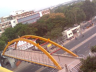
Peelamedu is a major commercial centre and residential locality in the Eastern part of the city of Coimbatore in Tamil Nadu, India. It is governed by Coimbatore City Municipal Corporation since 1981. The growth of Peelamedu during the last decade can be cited due to the growth of the IT sector in Coimbatore. The rapid growth of Peelamedu as a commercial and residential hub could be attributed to its geographical advantage in terms of the connectivity to other parts of the city. It acts as an important hub connecting the rapidly growing business class Information Technology corridor. The Peelamedu area stretches from Nava India to the Coimbatore International Airport near SITRA, encompassing major educational institutions, hospitals, and Industries.
Mooligaimangalam (Moolimangalam) is a small urban area located in Karur district in the Indian state of Tamil Nadu. It occupies the 3rd and 4th wards of Tamil Nadu Kagitha Alai Town Panchayat.
Kottur-Malayandipattinam or Kottur is the biggest panchayat town in Anaimalai_taluk of Coimbatore rural district in the Indian state of Tamil Nadu. Its short name is KM Pattinam. The name Kottur-Malayandipattinam is used to distinguish it from other places of the same name in south India, with Malayandipattinam (malai-yandi-pattanam) being the name of the southern part of the town and named after being surrounded by western ghats. It is famous for buying elephant ivory 100 years before, kottur Tamil meaning of kottu is elephant ivory and it also means the end of town.
Maniyakaranpalayam is a residential neighbourhood in the city of Coimbatore in Tamil Nadu, India.
Moongiltholuvu is a village and Village Panchayat in Udumalpet Taluk, Tirupur District, Tamil Nadu, India.
Kalthurai is a small and evergreen Village in Tamil Nadu, India and falls under village panchayat administrative unit of kottathurai in palani taluk, Dindigul District. Major river called Shanmuga Nadi is running through the village. The Shanmuganadi Dam is built across the Shanmugha Nadi in this village. Kalthurai is one of the best education village in Tamil Nadu.

Pugalur is a municipality in Karur district in Tamil Nadu, India. It has two parts: Nanjai Pugalur and Punjai Pugalur. Nanjai refers to land with plenty of water, and Punjai refers to land with few bodies of water.
Udayampalayam is part of Coimbatore North in the Indian state of Tamil Nadu. It is located 7 km from Coimbatore Railway Station and 18 km from the airport. This is the northern border of the Coimbatore corporation.
Pattuthurai or Pattudurai is a village in Tamil Nadu state in India, located in the Thalaivasal mandal of the Salem district, two kilometres from Thalaivasal, one of the biggest panchayat unions in the Attur taluk.
Sottaiyur is a village located in Punjai Pugalur Municipality in Karur District in the Indian state of Tamil Nadu.
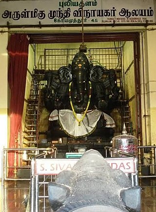
Puliakulam Vinayagar Temple, is a Hindu temple located in the neighbourhood of Puliakulam in Coimbatore, Tamil Nadu, India. It is dedicated to the god Munthi Vinayagar, a form of Ganesha.The temple holds the largest Vinayagar idol in the entire Asian Continent.

