Chirmiri

Last updated

Chirimiri
Municipal Corporation
Haldibadi 2008.jpg
Chirimiri
India Chhattisgarh location map.svg
Red pog.svg
Chirimiri
Location in Chhattisgarh, India
Coordinates: or 85317) 23°11′30″N82°21′15″E / 23.19167°N 82.35417°E / 23.19167; 82.35417
Country India
State Chhattisgarh
District Manendragarh-Chirmiri-Bharatpur
Government
  BodyMunicipal Corporation Chirmiri
   Mayor Kanchan Jaiswal (INC)
Population
 (2011)
  Total100,800 or 85,317
Languages
  Official
Time zone UTC+5:30 (IST)
PIN
497451, 497449, 497773
Telephone code07771
Vehicle registration CG32
chirmiri Chirmiri.jpeg
chirmiri

Chirmiri is a hill station city and a Municipal Corporation in the Manendragarh-Chirmiri-Bharatpur district in the Indian state of Chhattisgarh. It was a part of Koriya district until 15 August 2021 when the separate Manendragarh-Chirmiri-Bharatpur district was created. It is famously known for its coal extraction as the area is rich in coal.

Contents

Chirmiri, secured the top position in the Swacch Survekshan 2022 rankings for the '50,000-1 lakh' population category in the Eastern zone. The city was given the award for 'Fastest mover' city under the same category during Swacchh Survekshan 2020. For the 2022 Survekshan, Chirmiri scored 100% under categories like Waste generation vs processing, Remediation of Dumpsites, Cleanliness of Residential Areas, Cleanliness of Market Areas, Cleanliness Of Drains, and Cleanliness of Water Bodies. [1]

Chirimiri is referred to as the ‘Heaven/Jannat of Chhattisgarh’. The lush greenery, mountains and rivers make it a perfect getaway destination for anyone looking to relax. This scenic town is also known for its coal mines. There are several temples and other notable places that are famous among tourists. Chirimiri is well connected to major cities via rail and road. Chirimiri is situated at an altitude of 579 m above sea level. It lies along the bank of Hasdeo River. The river is one of the most prominent tributaries of the Mahanadi River. The weather is pleasant all year round, and there are dense forests in the region which houses exotic flora and fauna.

Geography

Coal Drag Line Drag line.jpg
Coal Drag Line
Hill station 00chrm.jpg
Hill station

Chirmiri city is located in the geographical coordinates of 23 degrees 11 minutes and 60 seconds north latitude and 82 degrees 20 minutes and 60 seconds east longitude. The total population of the city stands at 93,366 people. The total population is segmented into 49,128 males and 44,238 females. The town has achieved a high literacy rate with 61,280 total literates in the town. The number of male literates is more than the female literates in the town. As compared to the female literate count of 24,640, the number of male literates is 36,640.

Chirmiri is rich in the coal deposits found in the region. The coal industrial belt has developed in the region owing to the close proximity of the coal mines. The most reputed government undertaking and the largest coal producing industry in India, the South Eastern Coalfields Limited is located in the region. Chirmiri is one of the 13 administrative areas of the coal industry.

One of the chief tourist attractions of the region is the Lord Jagannath Temple that was designed like the temple in Puri in Odisha state. Chirmiri is endowed with beautiful landscape that the tourists may enjoy while journeying to the town.

Climate

Climate data for Chirmiri
MonthJanFebMarAprMayJunJulAugSepOctNovDecYear
Mean daily maximum °C (°F)23.5
(74.3)
26.9
(80.4)
32.0
(89.6)
38
(100)
42
(108)
40
(104)
29.7
(85.5)
29.3
(84.7)
29.8
(85.6)
29.4
(84.9)
26.5
(79.7)
23.7
(74.7)
30.9
(87.6)
Mean daily minimum °C (°F)8.7
(47.7)
11.4
(52.5)
15.7
(60.3)
20.9
(69.6)
24.7
(76.5)
24.8
(76.6)
23.2
(73.8)
22.9
(73.2)
22.1
(71.8)
18.1
(64.6)
12.2
(54.0)
8.5
(47.3)
17.8
(64.0)
Average rainfall mm (inches)22.8
(0.90)
22.7
(0.89)
24.7
(0.97)
13.4
(0.53)
19.4
(0.76)
212.4
(8.36)
428.0
(16.85)
383.2
(15.09)
225.4
(8.87)
55.6
(2.19)
8.9
(0.35)
6.3
(0.25)
1,422.8
(56.01)
Average rainy days3.13.73.42.83.313.423.322.515.45.31.01.298.4
Source: World Meteorological Organization [2]

History

old bridge Hasdev-bridge-chirimiri-jannat.jpg
old bridge

At first, it was privately owned coal-mines. Dadu Lehri, as he is lovingly called, is said to be the founder of Chirimiri. Tata Iron and Steel Company then initiated prospecting of coal but no mining was carried out by them. The Chirimiri colliery was opened in 1930 (production started in 1932), New Chirimiri colliery came up in 1942, Pure Chirimiri colliery in 1945, and North Chirimiri colliery in 1946. Subsequently, New Chirimiri Pondi Hills, West Chirimiri, Duman Hill and Korea collieries started operating. Coal production rose from 264,000 tonnes in 1933 to 3,162,500 tonnes in 1980. [3]

The collieries in Chirimiri Coalfield were owned by several companies and owners such as Chirimiri Colliery Company Pvt. Ltd., Dababhoy's New Chirimiri Ponri Hill Company (Private) Limited, United Collieries Limited, K.N. Dhady and Indra Singh & Sons (Private) Limited. These were nationalized in 1973.[ citation needed ]

Economy

Chirmiri is well known for its coal mines (see Chirimiri Coalfield). Mining began here in 1925. Chirmiri has a railway station that is used primarily to transport coal from the region. The coal industrial belt has developed in the region owing to the close proximity to the coal mines. The largest coal producing industry in India, the South Eastern Coalfields Limited is located in the region. Chirmiri is one of the 13 administrative areas of the coal industry.

Local Government

As per the Census 2011, Chirmiri was a Class-II town which had been granted the status of Municipal Corporation by the Chhattisgarh Government in 2008. The town is divided into 40 wards and nine zones and these nine zones are physically separated from each other by hilly mounts and forested areas. Chirmiri was part of the Koriya district until 2022, when the Manendragarh-Chirmiri Bharatpur (MCB) district was established [1] .

Demographics

As of 2001 India census, [4] Chirmiri had a population of 91,312, 53% male and 46% female. Chirmiri has an average literacy rate of 66% (male 75%, female 56%), higher than the national average of 59.5%. Fourteen per cent (14%) of the population is under six years of age.

Notable places

For the pilgrims, Chirimiri and places nearby offers temples like:

lord jaganth tample Jaganath tample chirimiri.jpg
lord jaganth tample

The Lord Jagannath Temple: This temple was built by the workers from Puri and is the replica of the Puri Jagannath Temple. This temple is a gift to Chirimiri by the Odia community of this region, who put their immense effort to make it a reality.

kalibadi temple Kalibadi-temple-chirimiri-chirimirijannat-1.jpg
kalibadi temple

Kalibadi: The temple is in Haldibadi. It is on a hill and only 1 km. from the main station.

Baigapara: is in the place called Bartunga and also Sati temple which is a very old temple in Bartunga dedicated to Sati maa.

Gufa Mandir: Located in Godaripara

Maha Maya Temple in Ratanpur: It is one of the 52 Shakthi Peeths, in India. The temple is dedicated to the deities Goddess Lakshmi and Goddess Saraswathi. The temple was built by the Kalachuri king Ratnadeva in the 12-13th century. The architecture is of the Nagara art, facing north with a big water tank. There is a Shiva and Hanuman temple on the premises. There is a temple dedicated to Kantideval, the oldest temple, built in 1039 said to be constructed by an ascetic known as Santhosh Giri. The temple is guarded by Kalabhairava residing in another temple on the approach road. There are ruins of an 11th-century Kadaeideol Shiva temple on a hill top near a fort.

Amrit Dhara Falls are in Barbaspur. The distance from Chirimiri is about 17 km. There is a famous Shiva temple in Sidh Baba mount, near the water falls. Apart from being a famous water fall, the place is used for picnics by the locals.

Hasdeo River: The local authority has developed the banks of the river and now this is a preferred picnic spot.

Related Research Articles

<span class="mw-page-title-main">Jharsuguda district</span> District in Odisha, India

Jharsuguda is a district in Odisha, India with Jharsuguda town as its headquarters. This region is rich in coal and other mineral reserves. Of late, many small and medium scale iron and steel units have been set up in the vicinity of Jharsuguda town, giving impetus to the industrial growth of the district.

<span class="mw-page-title-main">Koriya district</span> District of Chhattisgarh in India

Koriya district, officially known as Korea district, is a district in the north-western part of the Chhattisgarh state in Central India. The administrative headquarters of the district is Baikunthpur.

<span class="mw-page-title-main">Korba district</span> District of Chhattisgarh in India

Korba District is an administrative district of Chhattisgarh state in central India. The headquarter of this district is Korba.

<span class="mw-page-title-main">Manendragarh</span> City in Chhattisgarh in India

Manendragarh, is a city and administrative district headquarters of Manendragarh-Chirmiri-Bharatpur district in the state of Chhattisgarh, India. Formerly, it was the part of Koriya district. It is situated near the Chhattisgarh-Madhya Pradesh state border. The Chief Minister of Chhattisgarh state, Shri Bhupesh Baghel, inaugurated Manendragarh District on 9 September 2022 by separating it from korea district.

Amlabad is a census town in the Chandankiyari CD blocks in the Chas subdivision of the Bokaro district in the state of Jharkhand, India.

Bijuri is a town and a Municipality or Municipal Council or Nagar Palika Parishad in Anuppur district in the state of Madhya Pradesh, India.

Khongapani is a census town in manendragarh-Chirmiri-Bharatpur district in the Indian state of Chhattisgarh.

Nowrozabad or Khodargama is a city and a Nagar Palika in Umaria district in the Indian state of Madhya Pradesh. Kendriya Vidyalaya Nowrozabad is situated in the G.M Complex Johilla area. Nowrozabad is the head office of Johilla area. The nearest Airport is at Jabalpur in Madhya pradesh. Nowrozabad Railway Station is on the Katni - Anuppur rail route. There are many coal mines around here. National Highway 43 has its route through Nowrozabad.

Sarni is a town located in the Betul District of Madhya Pradesh. It is administered by the Municipal Council of Sarni, which oversees the four contiguous settlements of Sarni, Pathakhera, Shobhapur Colony and Bagdona.

Bhatgaon is a Census town and Nagar Panchayat in Surajpur district in the Indian state of Chhattisgarh. Bhatgaon is known for its South Eastern Coalfields Limited,.

Coal mining regions are significant resource extraction industries in many parts of the world. They provide a large amount of the fossil fuel energy in the world economy.

South Eastern Coalfields Limited (SECL) is the largest coal producing company of India. It is a "Miniratna" Company, and one of eight fully owned subsidiaries of Coal India Limited. The company has its headquarter at Bilaspur, Chhattisgarh, India and 92 mines spread over Chhattisgarh & Madhya Pradesh; 70 underground, 21 opencast, and 1 mixed. It is a schedule 'B' Mini Ratna CPSE in coal & lignite under the administrative control of the Ministry of Coal.

Sohagpur Coalfield is located in Shahdol district in the Indian state of Madhya Pradesh in the basin of the Son River. It is the biggest coalfield in the state of Madhya Pradesh.

Umaria Coalfield is located in Umaria district in the Indian state of Madhya Pradesh in the valley of the Umrer River, a tributary of the Son River.

Chirimiri Coalfield is located in manendragarh-chirmiri-bharatpur district in the Indian state of Chhattisgarh in the valley of the Hasdeo River, a tributary of the Mahanadi.

Jhilimili Coalfield is located in Surguja district in the Indian state of Chhattisgarh.

<span class="mw-page-title-main">Tourism in Chhattisgarh</span>

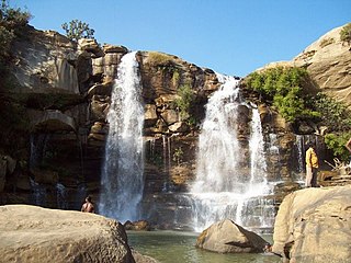
Tourism is an important part of the economy of the Indian state of Chhattisgarh, India's tenth largest state. The state has many ancient monuments, rare wildlife, carved temples, Buddhist sites, palaces, water falls, caves, rock paintings and hill plateaus.

<span class="mw-page-title-main">Amritdhara falls</span> Waterfall in Chhattisgarh, India

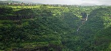
Amrit Dhara is a natural waterfall located in Manendragarh-Chirmiri-Bharatpur district, state of Chhattisgarh, India. It originates from the Hasdeo River, which is a tributary of the Mahanadi River. The fall is situated at a distance of 50 km from Chirmiri and 30 km from Manendragarh. The waterfall is ideally located on the Manendragarh-Baikunthpur road NH 43. The Amrit Dhara Waterfall in Manendragarh-Chirmiri-Bharatpur in Chhattisgarh in India falls from a height of 90.0 ft. The waterfall is about 10.0–15.0 ft wide.

<span class="mw-page-title-main">Hasdeo Arand</span> Forest in Chhattisgarh, India

Hasdeo Arand is a forest in the Indian state of Chhattisgarh in central India. The forest is 170,000 hectares in area and is home to a diverse ecology and adivasi communities such as the Gonds. It is on top of the Hasdeo Arand coalfield in the north of Chhattisgarh. The Government of India has proposed to mine the coal, which would destroy the forest. The Hasdeo river runs through the forest. The forest comes under the Korba, Surajpur, Surguja districts of the state.

<span class="mw-page-title-main">Manendragarh-Chirmiri-Bharatpur district</span> District of Chhattisgarh in India

Manendragarh-Chirmiri-Bharatpur district is a district of Chhattisgarh state in India. Earlier it was in Korea district. Manendragarh has been inaugurated as a separate District on September 9, 2022 by the Chief Minister of Chhattisgarh State Shri Bhupesh Baghel. administrative headquarters of the district is Manendragarh.

References

  1. 1 2 "Nagar in Focus" (PDF). Nagrika. 1 February 2024. Retrieved 7 March 2024.
  2. World Weather Information Service-Ambikapur, World Meteorological Organization. Retrieved 30 September 2012.
  3. Shri Kamal Sharma, Resource Development in Tribal India, p. 165, 1989, Northern Book Centre, 4221/1 Ansari Road, New Delhi, ISBN   81-85119-57-0
  4. "Census of India 2001: Data from the 2001 Census, including cities, villages and towns (Provisional)". Census Commission of India. Archived from the original on 16 June 2004. Retrieved 1 November 2008.

3. Tourist places in koriya district