Kings or King's may refer to:
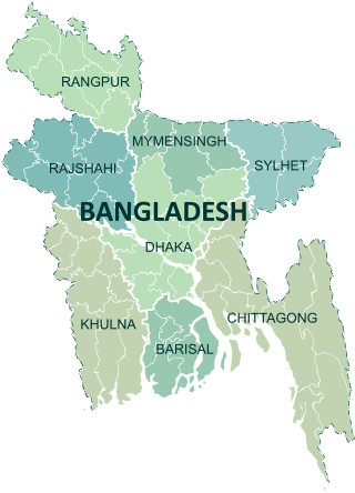
Divisions are the first-level administrative divisions in Bangladesh. As of 2023, there are eight divisions of Bangladesh, each named after the major city within its jurisdiction that also serves as the administrative seat of that division. Each division is divided into several districts which are further subdivided into upazilas, then union councils.

Feni is a coastal district situated in the south-east of Bangladesh, within the Chittagong Division. One of Bangladesh's smallest districts, it is strategically located along the Dhaka–Chittagong transportation corridor. Bordered by India to the north and the Bay of Bengal to the south, it serves as the sole entry point linking Chittagong, the country's primary port city, to the northern districts.
Chittagong, officially Chattogram, is the second-largest city in Bangladesh. Home to the Port of Chittagong, it is the busiest port in Bangladesh and the Bay of Bengal. It is the administrative seat of an eponymous division and district. The city is located on the banks of the Karnaphuli River between the Chittagong Hill Tracts and the Bay of Bengal. The Greater Chittagong Area had a population of more than 5.2 million in 2022. In 2020, the city area had a population of more than 3.9 million. The city is home to many large local businesses and plays an important role in the Bangladeshi economy.

Chittagong Division, officially known as Chattogram Division, is geographically the largest of the eight administrative divisions of Bangladesh. It covers the south-easternmost areas of the country, with a total area of 34,529.97 km2 (13,332.10 sq mi) and a population at the 2022 census of 33,202,326. The administrative division includes mainland Chittagong District, neighbouring districts and the Chittagong Hill Tracts.

Dhaka Division is an administrative division within Bangladesh. Dhaka serves as the capital city of the Dhaka Division, the Dhaka District and Bangladesh. The division remains a population magnet, covers an area of 20,508.8 km2 with a population in excess of 44 million, It is the most populous country second level division of the world, growing at 1.94% rate since prior count, compared with national average of 1.22%. However, national figures may include data skewing expatriation of male labor force as gender ratio is skewed towards females.

Sylhet Division, Bengali: সিলেট বিভাগ) is the northeastern division of Bangladesh. It is bordered by the Indian states of Meghalaya, Assam and Tripura to the north, east and south respectively, and by the divisions of Chittagong to the southwest and Dhaka and Mymensingh to the west.
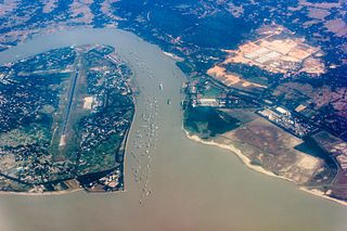
The Karnaphuli River is the largest and most important river in Chittagong and the Chittagong Hill Tracts. It is a 667-metre (2,188 ft) wide river in the south-eastern part of Bangladesh. Originating from the Saithah village of Mamit district in Mizoram, India, it flows 270 kilometres (170 mi) southwest through Chattogram Hill Tracts and Chattogram into the Bay of Bengal. It is the fastest flowing river in Bangladesh, after the Padma. It is said to "represent the drainage system of the whole south-western part of Mizoram." Principal tributaries include the Kawrpui River or Thega River, Tuichawng River and Phairuang River. A large hydroelectric power plant was built on the Karnaphuli in the Kaptai region in the 1960s. The mouth of the river hosts the Port of Chattogram, the largest and busiest seaport of Bangladesh.
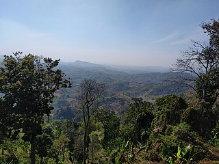
Rangamati Hill District is a district in south-eastern Bangladesh. It is a part of the Chattogram Division, and the town of Rangamati serves as the headquarters of the district. By area, Rangamati is the largest district of the country.

Bandarban is a district in South-Eastern Bangladesh, and a part of the Chittagong Division. It is one of the three hill districts of Bangladesh and a part of the Chittagong Hill Tracts, the others being Rangamati District and Khagrachhari District. Bandarban district (4,479 km2) is not only the most remote district of the country, but also the least populous. There is an army contingent at Bandarban Cantonment.

Bangladesh is divided into 8 divisions (bibhag) and 64 districts, although these have only a limited role in public policy. For the purposes of local government, the country is divided into upazilas (sub-districts), "municipalities" or town councils (pourashova), city corporations and union councils . The diagram below outlines the five tiers of government in Bangladesh.

Chittagong District, renamed the Chattogram District, is a district located in south-eastern Bangladesh. It is a part of the Chittagong Division. The port city of Chittagong, which is the second largest city in Bangladesh, is located within this district.

Eastern Bengal and Assam was a province of India between 1905 and 1912. Headquartered in the city of Dacca, it covered territories in what are now Bangladesh, Northeast India and Northern West Bengal.

Tourism in Bangladesh includes tourism to World Heritage Sites, historical monuments, resorts, beaches, picnic spots, forests, tribal people, and wildlife of various species. Activities for tourists include angling, water skiing, river cruising, hiking, rowing, yachting, beachgoing and sea bathing.
Gazipur may refer to several places:

Samataṭa was an ancient geopolitical division of Bengal in the eastern Indian subcontinent. The Greco-Roman account of Sounagoura is linked to the kingdom of Samatata. Its territory corresponded to much of present-day eastern Bangladesh and parts of the Rakhine State of Myanmar. The area covers the trans-Meghna part of the Bengal delta. It was a center of Buddhist civilisation before the resurgence of Hinduism, and Muslim conquest in the region.

The Government agencies in Bangladesh are state controlled organizations that act independently to carry out the policies of the Government of Bangladesh. The Government Ministries are relatively small and merely policy-making organizations, allowed to control agencies by policy decisions. Some of the work of the government is carried out through state enterprises or limited companies.