Kilakarai is a municipality in Ramanathapuram district in the Indian state of Tamil Nadu. As of 2011, the town had a population of 38,355. Kilakarai is one of the Taluka in Ramanathapuram District.
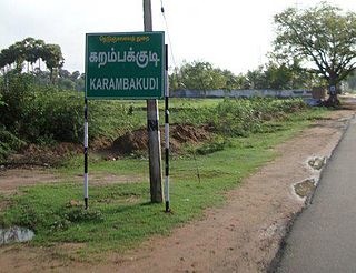
Karambakkudi is a panchayat town as well as Taluk in Pudukkottai district in the Indian state of Tamil Nadu. Karambakkudi is located about 40 km from Thanjavur and 40 km from Pudukkottai. This town is located on the border of the Thanjavur and Pudukkottai district in Tamil Nadu. The opinion of the people of this area is that this area should become an assembly constituency very soon, Here all higher secondary schools and Art's college is there.This area is covered by Delta Region.
Kilpennathur is a Panchayat Town in Tiruvanamalai district in the Indian state of Tamil Nadu. Kilpennathur is one of the taluks of Tiruvannamalai district and an assembly constituency of Tamil Nadu. The MLA of Kilpennathur assembly constituency is DMK party Mr. K. Pichandi. Vettavalam is the most populous town panchayat in this taluk. Kilpennathur is located a 12.25 degrees latitude and 79.224 degrees longitude. Nearest towns are Avalurpet, Vettavalam, Gingee and Tiruvannamalai, and Chennai is about 177 km away.

Madambakkam is a neighborhood in the city of Tambaram, situated within the Chennai Metropolitan Area, Tamil Nadu, India.

Manamadurai is a Municipality Town in Sivaganga district in the Indian state of Tamil Nadu. Manamadurai falls under Manamadurai Legislative assembly. It is a river based settlement town. River Vaigai makes its way through the town bifurcating it into two parts.

Muthupet is a panchayat town and taluk in the Thiruvarur district in the Indian state of Tamil Nadu. It is also known as Pearlpet. Muthupet comes under the Thiruthuraipoondi assembly constituency which elects a member to the Tamil Nadu Legislative Assembly every five years. The current member of the legislative assembly (MLA) is Marimuthu of the Communist Party of India, a part of the Nagapattinam, which elects its member of parliament (MP) every five years. The Muthupet city in-town panchayat was constituted in 1962. The town comes under the administrative territory of the Thiruvarur District. It extends over an area of 11.80 km2.

Nannilam is a Town and Taluk in Thiruvarur District in the Indian state of Tamil Nadu. It is the headquarters town for Nannilam Taluk.
Peravurani is a panchayat town in Thanjavur district in the Indian state of Tamil Nadu. It is the administrative headquarters of the Peravurani Taluk and Peravurani. It is declared as Selection Grade Town Panchayat.
Verkilambi is an interior rural area the district of Kanyakumari at the state of Tamil Nadu. This is a grade – I Town panchayat spread in a total area of 15.7 Sq. km and consists of 18 wards, represented by 18 councilors. The Executive officer is the administrative head and the elected Chairman is the political head of this Town Panchayat. This was constituted as Kumarankudy Village, Pathmanapapuram MLA Constituency, Nagercoil MP Constituency. The town is located at a distance of 5 km from Ponmanai Town Panchayat on the East, 5 km from Thiruvattar Town Panchayat on the west. 3 km from Kothanalloor Town Panchayat on the South. This town is located along the Kanyakumari, Thiruvananthapuram, National High way and Colachel – Kulasekaram state high way Road through this TP. This TP Constitutes its village component to talking an area of 3.25 Sq. km up graded as town Panchayat
Pudumadam is a village located in the Ramanathapuram district of the Indian state of Tamil Nadu. Situated near the old National Highway 49, which connects Kochi and Dhanushkodi, Pudumadam serves as a vital gateway to the picturesque Pamban Island. The village is approximately 25 kilometers away from the city of Ramanathapuram and 37 kilometers away from the renowned pilgrimage site of Rameswaram. The nearest train station is Uchippuli, located just 4 kilometers away from Pudumadam.

Erwadi is a village in Ramanathapuram District, Tamil Nadu. It belongs to Kilakarai Taluk and town panchayat. The village is the location of the grave and shrine of Qutb-us-Sultan Syed Ibrahim Badshah Shaheed, a ruler of Medina. Erwadi also belongs to Kadaladi assembly constituency, which is a part of Ramanathapuram. After the delimitations in 2009, Erwadi was joined to the Ramanathapuram assembly constituency. Erwadi is the second largest contributor for the revenue of Ramanthapuram District.
Kadaladi in Tamil Nadu is 108 km from Madurai. Kadaladi is situated between Mudukulathur and Sayalgudi. It is a taluk headquarters and a revenue region of Ramanathapuram district.
Muthuvijayapuram is a small village/hamlet located in Mudukulathur Block Ramanathapuram district of Tamil Nadu state in India. .It comes under Pirabakaloor Panchayat. It's located 25 km towards west from District headquarters Ramanathapuram.525 km from State capital chennai
Periyapattinam is a large village located in the eastern part of Ramanathapuram district, Tamil Nadu, India. The inhabitants of this village are primarily Tamil Muslim.
Kottaipattinam is a village panchayat located in the Pudukkottai district of Tamil Nadu state, India. The latitude 9.97908 and longitude 79.198595 are the geocoordinate of the Kottaipattinam. The Kottaipattinam Population is 13454. Male is 6668. Female is 6786.

Muttom is a rural area in Idukki district in the Indian state of Kerala. This place is 66 km away from Cochin. Geographically this place is part of Midland or Idanad region of Kerala.
Athiyuthu is a village located 17 km(10 Miles) from the center of Ramanathapuram district, Tamil Nadu, India. It has some similar places nearby, such as Chittarkottai, Panaikulam, Pudhuvalasai Alagankulam and Aatrangarai.
Appanur is a village in the Kadaladi Taluk of Ramanathapuram District in Tamil Nadu, India. It is located between Mudukulathur and Sayalgudi, on the State Highway 29 (SH29).
Ilanthaikoottam is a village in Chittarkottai Panchayat in Ramanathapuram district, Tamil Nadu, India.
Kethureddipatti is a Village Panchayat in Dharmapuri district of Tamil Nadu, India. It is located at 30 km (19 mi) from Dharmapuri town. It comes under Pappireddipatti taluk and Kadathur Block. It belongs to Pappireddipatti State Legislative Assembly Constituency and Dharmapuri Loksabha Constituency. It consists of nine panchayat wards. As per the 2011 Census, the total population of this village is 4,808.

