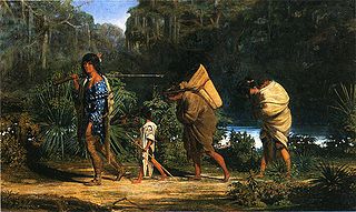
The Choctaw are a Native American people originally based in the Southeastern Woodlands, in what is now Alabama and Mississippi. Their Choctaw language is a Western Muskogean language. Today, Choctaw people are enrolled in three federally recognized tribes: the Choctaw Nation of Oklahoma, Mississippi Band of Choctaw Indians, and Jena Band of Choctaw Indians in Louisiana.

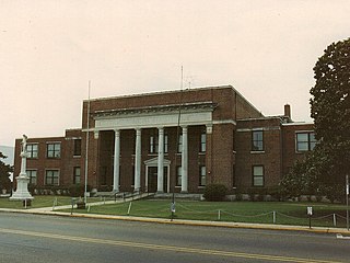
Choctaw County is a county located in the U.S. state of Oklahoma. As of the 2020 census, the population was 14,204. Its county seat is Hugo.

The Chickasaw are an Indigenous people of the Southeastern Woodlands, United States. Their traditional territory was in northern Mississippi, northwestern and northern Alabama, western Tennessee and southwestern Kentucky. Their language is classified as a member of the Muskogean language family. In the present day, they are organized as the federally recognized Chickasaw Nation.
Neshoba County is located in the central part of the U.S. state of Mississippi. As of the 2020 census, the population was 29,087. Its county seat is Philadelphia. It was named after Nashoba, a Choctaw chief. His name means "wolf" in the Choctaw language.

Coahoma County is a county located in the U.S. state of Mississippi. As of the 2020 census, the population was 21,390. Its county seat is Clarksdale.

Clarke County is a county located in the U.S. state of Mississippi. As of the 2020 census, the population was 15,615. Its county seat is Quitman. Clarke County is named for Joshua G. Clarke, the first Mississippi state chancellor and judge.

Choctaw County is a county located in the central part of the U.S. state of Mississippi. As of the 2020 census, the population was 8,246. Its northern border is the Big Black River, which flows southwest into the Mississippi River south of Vicksburg. The county seat is Ackerman.

Scouting in Mississippi has a long history, from the 1910s to the present day, serving thousands of youth in programs that suit the environment in which they live.

Itta Bena is a city in Leflore County, Mississippi, United States. The population was 2,049 at the 2010 census. The town's name is derived from the Choctaw phrase iti bina, meaning "forest camp". Itta Bena is part of the Greenwood, Mississippi micropolitan area. It developed as a trading center of an area of cotton plantations.

The Treaty of Dancing Rabbit Creek was a treaty which was signed on September 27, 1830, and proclaimed on February 24, 1831, between the Choctaw American Indian tribe and the United States Government. This treaty was the first removal treaty which was carried into effect under the Indian Removal Act. The treaty ceded about 11 million acres (45,000 km2) of the Choctaw Nation in what is now Mississippi in exchange for about 15 million acres (61,000 km2) in the Indian territory, now the state of Oklahoma. The principal Choctaw negotiators were Chief Greenwood LeFlore, Mosholatubbee, and Nittucachee; the U.S. negotiators were Colonel John Coffee and Secretary of War John Eaton.

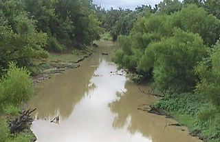
In usage in the Southern United States, a bayou is a body of water typically found in a flat, low-lying area. It may refer to an extremely slow-moving stream, river, marshy lake, wetland, or creek. They typically contain brackish water highly conducive to fish life and plankton. Bayous are commonly found in the Gulf Coast region of the southern United States, especially in the Mississippi River Delta, though they also exist elsewhere.
Choctaw is an unincorporated community and Indian reservation located in Neshoba County, Mississippi, United States. Choctaw is approximately 5.3 miles (8.5 km) west of Philadelphia along Mississippi Highway 16.

The Tombigbee River is a tributary of the Mobile River, approximately 200 mi (325 km) long, in the U.S. states of Mississippi and Alabama. Together with the Alabama, it merges to form the short Mobile River before the latter empties into Mobile Bay on the Gulf of Mexico. The Tombigbee watershed encompasses much of the rural coastal plain of western Alabama and northeastern Mississippi, flowing generally southward. The river provides one of the principal routes of commercial navigation in the southern United States, as it is navigable along much of its length through locks and connected in its upper reaches to the Tennessee River via the Tennessee-Tombigbee Waterway.
The Poteau River is a 141-mile (227 km) long river located in the U.S. states of Arkansas and Oklahoma. It is the only river in Oklahoma that flows north and is the seventh largest river in the state. It is a tributary of the Arkansas River, which itself is a tributary of the Mississippi River. During the Indian Territory period prior to Oklahoma's statehood (1838-1906), the stream served as the boundary between Skullyville County and Sugar Loaf County, two of the counties making up the Moshulatubbee District of the Choctaw Nation.
The Mississippi Band of Choctaw Indians is one of three federally recognized tribes of Choctaw people, and the only one in the state of Mississippi. On April 20, 1945, this tribe organized under the Indian Reorganization Act of 1934. Their reservation included lands in Neshoba, Leake, Newton, Scott, Jones, Attala, Kemper, and Winston counties. The Mississippi Choctaw regained stewardship of their mother mound, Nanih Waiya mounds and cave in 2008. The Mississippi Band of Choctaw have declared August 18 as a tribal holiday to celebrate their regaining control of the sacred site. The other two Choctaw groups are the Choctaw Nation of Oklahoma, the third largest tribe in the United States, and the Jena Band of Choctaw Indians, located in Louisiana.

The Amite River is a tributary of Lake Maurepas in Mississippi and Louisiana in the United States. It is about 117 miles (188 km) long. It starts as two forks in southwestern Mississippi and flows south through Louisiana, passing Greater Baton Rouge, to Lake Maurepas. The lower 37 miles (59.5 km) of the river is navigable. A portion of the river is diverted via the Petite Amite River and Amite Diversion Canal to the Blind River, which also flows to Lake Maurepas.

The Choctaw Trail of Tears was the attempted ethnic cleansing and relocation by the United States government of the Choctaw Nation from their country, referred to now as the Deep South, to lands west of the Mississippi River in Indian Territory in the 1830s by the United States government. A Choctaw Miko (chief) was quoted by the Arkansas Gazette as saying that the removal was a "trail of tears and death." Since removal, the Choctaw have developed since the 20th century as three federally recognized tribes: the largest, the Choctaw Nation of Oklahoma; the Mississippi Band of Choctaw Indians, and the Jena Band of Choctaw Indians in Louisiana.

The Choctaw in the American Civil War participated in two major arenas—the Trans-Mississippi and Western Theaters. The Trans-Mississippi had the Choctaw Nation. The Western had the Mississippi Choctaw. The Choctaw Nation had been mostly removed west prior to the War, but the Mississippi Choctaw had remained in the east. Both the Choctaw Nation and the Mississippi Choctaw would ultimately side with the Confederate States of America.
Lake Pushmataha is a 285-acre (115 ha) reservoir in the U.S. state of Mississippi.


