Chorkhamara Dam

Last updated

Chorkhamara Dam
India Maharashtra location map.svg
Red pog.svg
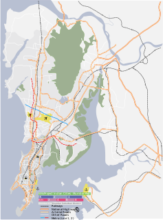
Location of Chorkhamara Dam in Maharashtra
Official nameChorkhamara Dam D01008
LocationTiroda
Coordinates 21°17′27″N79°56′51″E / 21.2909163°N 79.9474803°E / 21.2909163; 79.9474803 Coordinates: 21°17′27″N79°56′51″E / 21.2909163°N 79.9474803°E / 21.2909163; 79.9474803
Opening date1923 [1]
Owner(s) Government of Maharashtra, India
Dam and spillways
Type of dam Earthfill
ImpoundsSasanda river
Height21.05 m (69.1 ft)
Length1,178 m (3,865 ft)
Dam volume300 km3 (72 cu mi)
Reservoir
Total capacity20,800 km3 (5,000 cu mi)
Surface area5,235 km2 (2,021 sq mi)

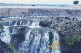
Chorkhamara Dam, is an earthfill dam on Sasanda river near Tiroda, Gondia district in the state of Maharashtra in India.

Gondia district District of Maharashtra in India

Gondia district is an administrative district in the state of Maharashtra in India. The district headquarter is located at Gondia. The district occupies an area of 5,431 km2 (2,097 sq mi) and has a population of 1,200,707 of which 11.95% were urban. The district is part of Nagpur Division. There are 8 Talukas in Gondia District. Gondia Airport, a nice Airport is serves the city of Gondia.

Maharashtra State in western India

Maharashtra is a state in the western peninsular region of India occupying a substantial portion of the Deccan plateau. It is the second-most populous state and third-largest state by area in India. Spread over 307,713 km2 (118,809 sq mi), it is bordered by the Arabian Sea to the west, the Indian states of Karnataka and Goa to the south, Telangana and Chhattisgarh to the east, Gujarat and Madhya Pradesh to the north, and the Indian union territory of Dadra and Nagar Haveli to the north west. It is also the world's second-most populous subnational entity.

India Country in South Asia

India, official name, the Republic of India,, is a country in South Asia. It is the seventh-largest country by area, the second-most populous country, and the most populous democracy in the world. Bounded by the Indian Ocean on the south, the Arabian Sea on the southwest, and the Bay of Bengal on the southeast, it shares land borders with Pakistan to the west; China, Nepal, and Bhutan to the north; and Bangladesh and Myanmar to the east. In the Indian Ocean, India is in the vicinity of Sri Lanka and the Maldives; its Andaman and Nicobar Islands share a maritime border with Thailand and Indonesia.

Contents

Specifications

The height of the dam above lowest foundation is 21.05 m (69.1 ft) while the length is 1,178 m (3,865 ft). The volume content is 300 km3 (72 cu mi) and gross storage capacity is 21,051.00 km3 (5,050.40 cu mi). [2]

Purpose

See also

Related Research Articles

Mandohol Dam

Mandohol Dam, is an earth-fill dam on Mandohol River in Karjule Hareshwar village of Parner taluka in Ahmednagar district of state of Maharashtra in India.

Tikhol Dam dam in India

Tikhol Dam is an earth-fill dam on Kalu river in Tikhol village in Parner taluka of Ahmednagar district of state of Maharashtra in India.

Lonimavla Dam

Lonimavla Dam, is an earth-fill dam in Lonimawala village in Parner taluka of Ahmednagar district of state of Maharashtra in India.

Dhoki Dam

Dhoki Dam, is an earth-fill dam on Kalu river in Dhoki village in Parner taluka of Ahmednagar district of state of Maharashtra in India.

Vihar Dam dam in India

Vihar dam, is an earthfill dam on Vihar river in Mumbai, near Bhandup in the state of Maharashtra in India.

Tansa Dam dam in India

Tansa dam, is an earthfill and gravity dam on Tansa river near Mumbai, Thane district in the state of Maharashtra in India. The dam is one of the seven sources of drinking water to the city of Mumbai.

Visapur Dam dam in India

Visapur Dam, is an earthfill dam on Hanga river near Srigonda, Ahmednagar district in the state of Maharashtra in India.

Upper Dudhana Dam, is an earthfill dam on Dudhana river near Jalna in the state of Maharashtra in India.

Itiadoh Dam dam in India

Itiadoh Dam, is an earthfill and gravity dam on Gadvi river near Arjuni Morgaon, Gondia district in state of Maharashtra in India. Constructed by: Senior engineer Mr.chandan rajaram barekar

Morna Gureghar Dam dam in India

Morna Dam, also called as Gureghar dam, is an earthfill dam on local river near Patur, Satara district in the state of Maharashtra in India.

Adhala Dam dam in India

Abhishek pawar

Morna Dam, Shirala dam in India

Morna Dam, also called Shirala Dam, is an earthfill dam on Morna river near Shirala, Sangli district in the state of Maharashtra in India.

Tillari (Main) Dam

Tillari (Main) Dam, is a gravity dam on Tillari river near Chandgad, Kolhapur district in the state of Maharashtra in India.

Sina Dam dam in India

Sina Dam, is an earthfill dam on Sina river near Karjat in Ahmednagar district in the state of Maharashtra in India.

Kanher Dam dam in India

Kanher Dam, is an earthfill and gravity dam on Wenna river near Satara in state of Maharashtra in India.

Khairi Dam dam in India

Khairi Dam is an earthfill dam on the Kar river near Jamkhed, Ahmednagar district in the state of Maharashtra in India.

Hetwane Dam, is an earthfill dam on Bhogeshwari river near Pen, Raigad district in the state of Maharashtra in India.

Uttarmand Dam dam in India

Uttarmand Dam, is an earthfill dam on Uttarmand river near Patan, Satara district in the state of Maharashtra in India.

Bhivargi Dam dam in India

Bhivargi Dam, is an earthfill dam on Patan river near Jat, Sangli district in state of Maharashtra in India.

Kudnur Dam dam in India

Kudnur Dam, is an earthfill dam on local river near Chandgad, Kolhapur district in state of Maharashtra in India.

References

  1. "Chorkhamara D01008" . Retrieved 4 March 2013.[ permanent dead link ]
  2. Specifications of large dams in India Archived 21 July 2011 at the Wayback Machine