
The Republic of Colombia is situated largely in the north-west of South America, with some territories falling within the boundaries of Central America. It is bordered to the north-west by Panama; to the east by Brazil and Venezuela; to the south by Ecuador and Peru; and it shares maritime limits with Costa Rica, Nicaragua, Honduras, Jamaica, the Dominican Republic, and Haiti.

Southcentral Alaska, also known as the Gulf Coast Region, is the portion of the U.S. state of Alaska consisting of the shorelines and uplands of the central Gulf of Alaska. More than half of the state's entire population lives in this region, concentrated in and around the city of Anchorage. The region is Alaska’s best-connected region, with the Port of Anchorage, Ted Stevens, Anchorage International Airport, and the Alaska Railroad servicing the area.

Caracas, officially Santiago de León de Caracas (CCS), is the capital and largest city of Venezuela, and the center of the Metropolitan Region of Caracas. Caracas is located along the Guaire River in the northern part of the country, within the Caracas Valley of the Venezuelan coastal mountain range. The valley is close to the Caribbean Sea, separated from the coast by a steep 2,200-meter-high (7,200 ft) mountain range, Cerro El Ávila; to the south there are more hills and mountains. The Metropolitan Region of Caracas has an estimated population of almost 5 million inhabitants.
The Geography of Guyana comprises the physical characteristics of the country in Northern South America and part of Caribbean South America, bordering the North Atlantic Ocean, between Suriname and Venezuela, with a land area of approximately 214,969 square km. The country is situated between 1 and 9 north latitude and between 56 and 62 west longitude. With a 459 km (285 mi)-long Atlantic coastline on the northeast, Guyana is bounded by Venezuela on the west, Brazil on the west and south, and Suriname on the east.
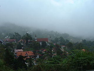
Colonia Tovar is a cold mountain town of Venezuela, capital of the municipality Tovar in Aragua state. It is located about 65.5 km (41 mi) west of Caracas. It was founded on April 8, 1843, by a group of 390 immigrants from the then independent state of the Grand Duchy of Baden. It is characterized by the cultural imprint of its origin, so it is called "the Germany of the Caribbean". The economy depends primarily on agriculture and tourism. Colonia Tovar is known for its temperate crops and their derivatives. Since 1990 it has experienced high population growth, rising from 3,373 to 21,000 inhabitants in 2016.
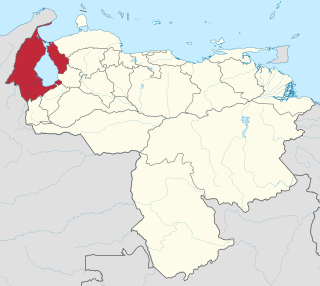
Zulia State is one of the 23 states of Venezuela. The state capital is Maracaibo. As of the 2011 census, it has a population of 3,704,404, the largest population among Venezuela's states. It is also one of the few states in Venezuela in which voseo is widespread. The state is coterminous with the eponymous region of Zulia.

Aragua State is one of the 23 states of Venezuela. It is located in the north-central region of Venezuela. It has plains and jungles and Caribbean beaches. The most popular are Cata and Choroni. It has Venezuela's first national park which is called Henri Pittier. The capital is Maracay, other important cities include Turmero and El Limón.
Coast Range, Coastal Range or Coast Mountains may refer to:
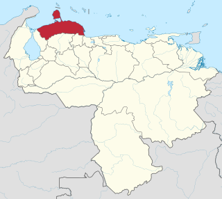
Falcón State is one of the 23 states of Venezuela. The state capital is Coro.
The Nueva Esparta State is one of the 23 states of Venezuela. It comprises Margarita Island, Coche, and the largely uninhabited Cubagua.

La Guaira State, known until 2019 as Vargas State is one of the 23 states of Venezuela. Formerly named after Venezuela's first civilian president, José María Vargas, Vargas comprises a coastal region in the north of Venezuela, bordering Aragua to the west, Miranda to the east, the Caribbean Sea to the north and the Capital District to the south. It is home to both the country's largest seaport and airport. The state capital is La Guaira. The Litoral Varguense conurbation is the principal urban agglomeration in the state, which is part of the Greater Caracas Area.

Margarita Island is the largest island in the Venezuelan state of Nueva Esparta, situated off the northeastern coast of the country, in the Caribbean Sea. The capital city of Nueva Esparta, La Asunción, is located on the island.
Chuao is a small village located in the northern coastal range mountains of Venezuela, founded in 1660. The village is famous for its cacao plantations, Diablos danzantes and San Juaneras. The village is surrounded by mountains and dense rainforests to the south and the Caribbean Sea to the north. The nearby Henri Pittier National Park is the oldest national park in Venezuela, created in 1937. The village is only accessible by travelling via boat from nearby Choroní, and is approximately 4 kilometers inland.

Henri Pittier National Park is the oldest national park in Venezuela, originally created in 1937 under the name of Rancho Grande by decree of President Eleazar López Contreras. In 1953 the park was renamed in honor of Henri Pittier, a distinguished Swiss geographer, botanist and ethnologist, who arrived in Venezuela in 1917, classified more than 30,000 plants in the country and devoted many years studying the flora and fauna in the park.

Choroní is a popular place located in Aragua, Venezuela. Its proper name is Choroní, but because of its proximity to the colonial not official village of Choroní, it is often referred to as Playa Grande or El Malecon.

The Andean Region is one of the 10 administrative regions in which Venezuela was divided for its development plans in 1969.

The Venezuelan Coastal Range, also known as Venezuelan Caribbean Mountain System, is a mountain range system and one of the eight natural regions of Venezuela, that runs along the central and eastern portions of Venezuela's northern coast. The range is a northeastern extension of the Andes, and is also known as the Maritime Andes. It covers around 48,866 km2, being the 4th largest natural region in Venezuela.

The Central Region is one of the 10 administrative regions in which Venezuela is divided. It's conformed by the states Aragua, Carabobo and Cojedes.

Tourism in Venezuela has been developed considerably for decades, particularly because of its geographical position, the variety of landscapes, the richness of plants and wildlife, the artistic expressions and the privileged tropical climate of the country, which affords each region throughout the year. Since 2013 the country is having a very severe economic and political crisis affecting tourism all over the country.

Because of its natural structure, Venezuela can be divided into eight very distinct natural regions. In the evaluation of a natural region, the human element is not present. The natural region groups of Venezuela formed as a consequence of the association of geo-physical elements such as: geological constitution, relief, climate, hydrography, vegetation, soils, among others.
