
Christchurch is the largest city in the South Island of New Zealand and the seat of the Canterbury Region. Christchurch lies on the South Island's east coast, just north of Banks Peninsula on Pegasus Bay. The Avon River / Ōtākaro flows through the centre of the city, with an urban park along its banks.

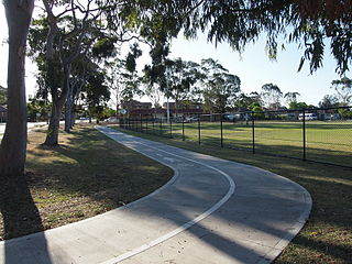
Papanui is a major suburb of Christchurch, New Zealand. It is situated five kilometres to the northwest of the city centre. Papanui is a middle socio-economic area with a population of 3,645 consisting predominantly of Pākehā 86.9%, Asian 7.6%, Māori 5.3%, Pacific peoples 3.1%, Middle Eastern/Latin American/African 0.7%. The suburb is located at the junction of three busy thoroughfares; Papanui Road leading to the city, the Main North Road that leads to North Canterbury and Harewood Road that leads to Christchurch International Airport. However, as with most Christchurch suburbs, Papanui has no defined borders.

Fendalton is a suburb of Christchurch, in the South Island of New Zealand.

Rolleston is the seat and largest town in the Selwyn District, in the Canterbury region of New Zealand's South Island. It is located on the Canterbury Plains 22 kilometres (14 mi) south-west of Christchurch, and is part of the wider Christchurch metropolitan area. The town has a population of 29,600, making it New Zealand's 23rd-largest urban area and the second-largest in Canterbury.

Bryndwr is a suburb in the north-west of Christchurch, New Zealand.

The Chandler Highway is a short road in the inner eastern suburbs of Melbourne. It runs from Heidelberg Road in Alphington, crosses the Yarra River, then continues across the Eastern Freeway, then terminates at an intersection with Princess Street and Earl Street. Its total length is less than 2 kilometres, leading to the claim that it is "the shortest highway in the world". It was named after a prominent local businessman and politician A. E. Chandler, who was instrumental in pushing through the development of the Outer Circle railway.

Ilam is a New Zealand parliamentary electorate. Formed for the 1996 election, it was held by Gerry Brownlee of the National Party until the 2020 election, when Sarah Pallett of the Labour Party unseated Brownlee in an upset victory. The seat reverted to National when it was won by Hamish Campbell in the 2023 election.

The Christchurch tramway system was an extensive network in Christchurch, New Zealand, with steam and horse trams from 1882. Electric trams ran from 1905 to 1954, when the last line from Cashmere to Papanui was replaced by buses.
The Christchurch Southern Motorway is the main southern route into and out of Christchurch, New Zealand. The motorway forms part of State Highway 1 and State Highway 76.
The Christchurch Northern Motorway is the main northern route into and out of Christchurch, New Zealand. The motorway forms part of State Highway 1 and State Highway 74.
Bike paths in Sydney, New South Wales, Australia, vary widely, with the majority either shared cycle and pedestrian paths or on road paths, and a small number of separated cycleways. In 2009 the Sydney Morning Herald reported that "Sydney's cycleways are not so much an organised network as a fragmented collection of winding paths and half-finished ideas. Most were built or designed when cycling was viewed as a pleasant pastime rather than a practical form of travel and are now poorly suited to commuting."
Christchurch tramway routes have developed from lines that were first established by a troika of private tramway companies in the latter part of the 19th century, through to a significantly expanded system under the municipal Christchurch Tramway Board, to the City Council-built heritage circuit. These routes have been worked by all three main forms of tramway motive power and have significantly contributed to the development of Christchurch City in New Zealand's South Island.

The Christchurch Transport Board was an autonomous special-purpose municipal authority responsible for the construction, acquisition, and ownership of local transport assets and the operation of public transport services in the Christchurch region of New Zealand's South Island. Constituted as the Christchurch Tramway Board in 1902, it operated trams and buses to Christchurch's outer suburbs and satellite towns for 84 years until being disestablished in the 1989 local government reforms.

The Dublin–Galway Greenway is a partially completed 'coast-to-coast' greenway and partial rail trail, in Ireland, funded by the Department of Transport, which is due to become the western section of EuroVelo EV2, a cycle route from Galway, Ireland, crossing Europe and ending in Moscow, Russia. The 276 km route was planned to be completed by 2020. It is due to be the fourth greenway in Ireland, after the Great Southern Trail, the Great Western Greenway and the Waterford Greenway.

The Nelson Street Cycleway is a cycleway in Auckland, New Zealand. The most well-known section of the path is Te Ara I Whiti, translated as, and commonly known as Lightpath. The cycleway then continues on to the Nelson Street arterial road into the City Centre.
The Cooks River cycleway, also called the Bay to Bay Shared Pathway, is a 30-kilometre-long (19 mi) shared use path for cyclists and pedestrians in the Inner West of Sydney, New South Wales, Australia. The north-western terminus of the cycleway is in Settlers' Park, Ryde, from where it proceeds south, crossing the Parramatta River and skirting Homebush Bay to the Cooks River, from where it generally follows the course of the river south and east to the south-eastern terminus on Botany Bay at Kyeemagh. The alternative name "Bay to Bay" or "B2B" path refers to Homebush Bay and Botany Bay. The path connects a series of parklands in the City of Ryde and the Municipality of Strathfield, as well as the riverside green spaces along the course of the Cooks River.

The Four Avenues are a group of four major arterial boulevards — Bealey Avenue, Fitzgerald Avenue, Moorhouse Avenue, and either Rolleston Ave or Deans Avenue — that surround the city centre of Christchurch, New Zealand. Serving as an inner ring road, they popularly form the limits of the city centre, separating it from the city's suburbs. Almost all of the city's commercial heart lies within the approximately rectangular 9.8-square-kilometre (3.8 sq mi) area formed by the four avenues. The term "within the Four Avenues" is widely used in Christchurch to refer to the central city. By extension, Christchurch as a whole is sometimes referred to as "The Four Avenues".
Te Ara ki Uta ki Tai, also known as the Glen Innes to Tamaki Drive shared path, is a shared pathway connecting the suburbs of Ōrākei and Glen Innes in Auckland, New Zealand. It runs through the Pourewa Valley and the Eastern Transport Corridor, and for most of its length is adjacent to the North Island Main Trunk railway line.
The 2022 Christchurch local elections were held via postal voting between September and October 2022 as part of the wider 2022 New Zealand local elections. Elections in Christchurch covered one territorial authority, the Christchurch City Council, and six community boards.

