Christiansdorf (Freiberg)

Last updated

Coordinates: 50°55′08″N13°20′52″E / 50.91889°N 13.34778°E / 50.91889; 13.34778

Geographic coordinate system Coordinate system

A geographic coordinate system is a coordinate system that enables every location on Earth to be specified by a set of numbers, letters or symbols. The coordinates are often chosen such that one of the numbers represents a vertical position and two or three of the numbers represent a horizontal position; alternatively, a geographic position may be expressed in a combined three-dimensional Cartesian vector. A common choice of coordinates is latitude, longitude and elevation. To specify a location on a plane requires a map projection.

House on the Schuppchenberg Freiberg Wasserturmstrasse 34.jpg
House on the Schüppchenberg

Christiansdorf, historically spelt Christianesdorph in 1183 and Christianisdorf in 1185, was a forest settlement in the Duchy of Saxony (the present day German state of Saxony) that only existed for a few years, but is credited as being the first place in the Ore Mountains that silver ore was discovered. The little mining settlement in the March of Meissen and was a forerunner of the present town of Freiberg, which itself was founded in the 1160s. Christiansdorf was located on the so-called Schüppchenberg hill, where the cul-de-sac of Berggasse now is.

<i>Waldhufendorf</i> type of village

The Waldhufendorf is a form of rural settlement established in areas of forest clearing with the farms arranged in a series along a road or stream, like beads on a chain. It is typical of the forests of central Germany and is a type of Reihendorf, in which each farmstead usually has two wide strips of land adjacent to the farmhouse.

Duchy of Saxony duchy

The Duchy of Saxony was originally the area settled by the Saxons in the late Early Middle Ages, when they were subdued by Charlemagne during the Saxon Wars from 772 and incorporated into the Carolingian Empire (Francia) by 804. Upon the 843 Treaty of Verdun, Saxony was one of the five German stem duchies of East Francia; Duke Henry the Fowler was elected German king in 919.

Saxony State in Germany

Saxony, officially the Free State of Saxony, is a landlocked federal state of Germany, bordering the federal states of Brandenburg, Saxony Anhalt, Thuringia, and Bavaria, as well as the countries of Poland and the Czech Republic. Its capital is Dresden, and its largest city is Leipzig.

According to oral tradition and legend, the first ore - sterling silver - in the Freiberg Mining Field, and also in the whole Ore Mountains, was discovered on the fields of Christiansdorf by the Schüppchenberg around 1168. [1]

Freiberg Mining Field

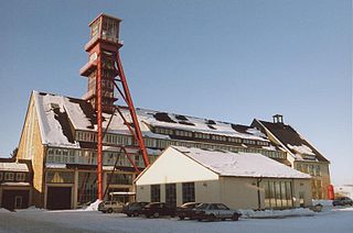
The Freiberg Mining Field is an ore field which, in its widest sense, is located on an ore deposit of precious and non-ferrous metals roughly 35 x 40 kilometres in area in the lower Eastern Ore Mountains in the German Free State of Saxony. The mining region is centred on Freiberg, but extends beyond that town's borough into the municipalities of Halsbrücke, Hilbersdorf, Bobritzsch, Weißenborn, Oberschöna and the boroughs of Brand-Erbisdorf and Großschirma. Mining has been carried out here since the last third of the 12th century. In a narrower sense the name refers to the area covered by the Freiburg and Halsbrück mining territories. The Brand Mining Field immediately to the south comprises just the one mining territory, the Brander Grubenfeld.

Ore Mountains low mountain range in central Europe

The Ore Mountains or Ore Mountain Range in Central Europe have formed a natural border between Saxony and Bohemia for around 800 years, from the 12th to the 20th centuries. Today, the border between Germany and the Czech Republic runs just north of the main crest of the mountain range. The highest peaks are the Klínovec, which rises to 1,244 metres (4,081 ft) above sea level and the Fichtelberg.

Related Research Articles

Annaberg district District in Saxony, Germany

Annaberg is a former district in the Free State of Saxony, Germany. It was bounded by the Czech Republic and the districts of Aue-Schwarzenberg, Stollberg and Mittlerer Erzgebirgskreis. Its colors are pink, green, and blue.

Freiberg (district) District in Saxony, Germany

Freiberg is a former district in the Free State of Saxony, Germany. It was bounded by the district of Mittlerer Erzgebirgskreis, the city of Chemnitz, the districts of Mittweida, Meißen and Weißeritzkreis, and by the Czech Republic.

Mittweida (district) District in Saxony, Germany

Mittweida is a former district in the Free State of Saxony, Germany. It was bounded by the districts Muldentalkreis, Döbeln, Freiberg, the district-free city Chemnitz and the district Chemnitzer Land, the district Altenburger Land in Thuringia and the district Leipziger Land.

Freiberg University of Mining and Technology university

The Technische Universität Bergakademie Freiberg is a German university of technology with about 4300 students in the city of Freiberg, Saxony. It was established in 1765 by Prince Franz Xaver, regent of Saxony, based on plans by Friedrich Wilhelm von Oppel and Friedrich Anton von Heynitz, and is the oldest university of mining and metallurgy in the world. The chemical elements indium (1863) and germanium (1886) were discovered by scientists of Freiberg University. The polymath Alexander von Humboldt studied mining at the Bergakademie Freiberg in 1791/1792.

Marienberg Place in Saxony, Germany

Marienberg is a town in Germany. It was the district capital of the Mittlerer Erzgebirgskreis in the southern part of Saxony, and since August 2008 it has been part of the new district of Erzgebirgskreis. As of 2007, the town had 14,181 inhabitants.

Brand-Erbisdorf Place in Saxony, Germany

Brand-Erbisdorf is a small town in the district of Mittelsachsen, in the Free State of Saxony, Germany. It is situated 5 km south of Freiberg. As of 2017, the town has a population of 9,544.

Silver Road

The 140-kilometre-long road, the Silver Road is the first and longest holiday route in the German Free State of Saxony. Against the background of the importance of mining in the history of Saxony, the road links those sights and tourist attractions of the Ore Mountains and its foreland that relate to the centuries-old mining and smelting industries of the region.

Mittelsachsen District in Saxony, Germany

Mittelsachsen is a district (Kreis) in the Free State of Saxony, Germany.

Clausnitz Subdivision of Rechenberg-Bienenmühle in Saxony, Germany

Clausnitz is a village in the municipality of Rechenberg-Bienenmühle in the Saxon district of Mittelsachsen. It lies in the Eastern Ore Mountains, in the valley of the Rachel, a tributary of the Freiberger Mulde. Clausnitz emerged during the clearings of the 12th century. It is a typical Waldhufendorf, that has preserved its tidy, village character today with its rural two- and three-sided farmsteads and timber-framed houses.

Rauenstein Castle castle in Lengefeld, Erzgebirge, Saxony

Rauenstein Castle is a castle in the village of Rauenstein in the town of Pockau-Lengefeld in the Ore Mountains of Central Europe. The castle guarded the crossing over the River Flöha along the road from Freiberg to Annaberg.

Ore Mountain Museum

The Ore Mountain Museum is a museum in Annaberg-Buchholz in the German state of Saxony and located in the Ore Mountains of Central Europe. Its display includes examples of Ore Mountain folk art, especially carvings, bobbin work and passements) and gives an insight into the history of the town of Annaberg and of silver mining in the region. The museum also owns a work from the workshop of Lucas Cranach the Younger from 1572 and a large collection of valuable pewter vessels. Adjoining the museum is the visitor mine of Im Gößner.

Berggeschrey or Berggeschrei was a German term for the rapid spread of news on the discovery of rich ore deposits that led to the rapid establishment of a mining region, as in the silver rush in the early days of silver ore mining in the Ore Mountains. It is similar in some respects to the gold rush in North America.

The Revierwasserlaufanstalt Freiberg or RWA Freiberg, was a historical water management system that delivered driving water to the Freiberg mines in the German state of Saxony. Today the system is used to supply drinking and industrial water and is operated by the Saxony State Reservoir Office.

Ore Mountain Mining Region

The Ore Mountain Mining Region is an industrial heritage landscape, over 800 years old, in the border region between the German state of Saxony and North Bohemia in the Czech Republic. It is characterised by a plethora of historic, largely original, monuments to technology, as well as numerous individual monuments and collections related to the historic mining industry of the region. The identity and authenticity of the mining heritage landscape of the Ore Mountains on both sides of the German-Czech border has no equivalent anywhere in the world, and if the region succeeds in being recognised as a UNESCO world heritage site - for which it has been nominated - it should help to preserve it for future generations as a "developing cultural landscape".

Saxon Mining Office government agency

The Saxon Mining Office is the executive authority for mining rights in the German state of Saxony. It is also responsible for all non-metallic mineral resources on the terrain of the former East Germany.

Freudenstein Castle château

Freudenstein Castle is located on the Schloßplatz on the edge of the town centre of Freiberg in the German state of Saxony. Its history is closely linked to the House of Wettin. After several conversions the castle is now a stately home with four wings comprising these buildings: the Langes Haus, Neues Haus, Kirchenflügel, Großer Turm und Schmales Haus.

Freibergsdorf Hammer Mill

The Freibergsdorf Hammer Mill is an old hammer works that was used for metalworking in the village of Freibergsdorf in the German Ore Mountains. The site represents an important witness to proto-industrial development in the Ore Mountains. Of the once-numerous hammer mills, only three others remain working in Saxony: the Frohnauer Hammer, the Dorfchemnitz Iron Hammer Mill, and the Grünthal Copper Hammer Mill.

References

  1. Kleine Chronik von Freiberg als Führer durch Sachsens Berghauptstadt und Beitrag zur Heimatkunde, Heinrich Gerlach, 2nd fully revised edition, Gerlach'sche Buchdruckerei, 1897