
The Leonard P. ZakimBunker Hill Memorial Bridge is a cable-stayed bridge completed in 2003 across the Charles River in Boston, Massachusetts. It is a replacement for the Charlestown High Bridge, an older truss bridge constructed in the 1950s.

The Blue Line is a rapid transit line in the Greater Boston metropolitan area, one of four rapid transit lines operated by the Massachusetts Bay Transportation Authority (MBTA). It runs from Bowdoin station in downtown Boston under Boston Harbor to East Boston and Revere on the inner North Shore, where it terminates at Wonderland. The stop at Airport Station, by way of a free shuttle bus, is one of two rapid transit connections to Logan International Airport. In 1967, during a systemwide rebranding, the line was assigned the blue color because it passes under the Boston Harbor. With an end-to-end travel time of less than twenty minutes, the Blue Line is the shortest of Boston's heavy-rail lines and the only line to have both third rail and overhead catenary sections.

Airport station is a rapid transit station in Boston, Massachusetts. It serves the MBTA Blue Line and the SL3 branch of the Silver Line. It is located in East Boston under the interchange between Interstate 90 and Massachusetts Route 1A. The station provides one of two mass transit connections to the nearby Logan International Airport, as well as serving local residents in East Boston. Shuttle buses connect the station with the airport terminals and other facilities.

JFK/UMass station is a Massachusetts Bay Transportation Authority (MBTA) intermodal transfer station, located adjacent to the Columbia Point area of Dorchester, Boston, Massachusetts. It is served by the rapid transit Red Line; the Greenbush Line, Kingston/Plymouth Line, and Middleborough/Lakeville Line of the MBTA Commuter Rail system, and three MBTA bus routes. The station is named for the John F. Kennedy Presidential Library and Museum and the University of Massachusetts Boston, both located nearby on Columbia Point.

The Boston, Revere Beach and Lynn Railroad was a 3 ft narrow-gauge passenger-carrying shortline railroad between East Boston and Lynn, Massachusetts, from 1875 to 1940. Part of the railroad's right of way now forms the outer section of the Massachusetts Bay Transportation Authority's Blue Line rapid transit service.
The Massachusetts Bay Transportation Authority (MBTA) operates 152 bus routes in the Greater Boston area. The MBTA has a policy objective to provide transit service within walking distance for all residents living in areas with population densities greater than 5,000 inhabitants per square mile (1,900/km2) within the MBTA's service district. Much of this service is provided by bus. In 2023, the system had a ridership of 91,459,700, or about 322,600 per weekday as of the third quarter of 2024.

Hynes Convention Center station is an underground light rail station on the Massachusetts Bay Transportation Authority (MBTA) Green Line. It is located at the intersection of Newbury Street and Massachusetts Avenue near the western end of the Back Bay neighborhood of Boston, Massachusetts. The station is named for the Hynes Convention Center, which is located about 700 feet (210 m) to the east along Boylston Street. It has two side platforms serving the two tracks of the Boylston Street subway, which are used by the Green Line B branch, C branch, and D branch. The main entrance to the station from Massachusetts Avenue leads to a fare lobby under the 360 Newbury Street building.

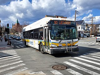
Key bus routes of the Massachusetts Bay Transportation Authority (MBTA) system were the 15 routes that had high ridership and higher frequency standards than other bus lines, according to the 2004 MBTA Service Policy. Together, they accounted for roughly 40% of the MBTA's total bus ridership. These key bus routes ensured basic geographic coverage with frequent service in the densest areas of Boston, and connected to other MBTA services to give access to other areas throughout the region.

Revere Beach station is a rapid transit station in Revere, Massachusetts. Located between Beach Street and Shirley Avenue, it serves the MBTA Blue Line. It serves Revere Beach, a popular summer destination with a substantial year-round resident population. It opened in January 1954 on the site of a former Boston, Revere Beach and Lynn Railroad station, as part of an extension to Wonderland. Revere Beach station was closed and rebuilt from 1994 to 1995.
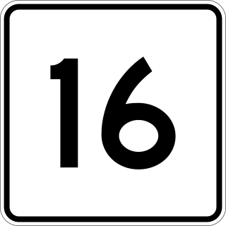
Revere Beach Parkway is a historic parkway in the suburbs immediately north of Boston, Massachusetts. It begins at Wellington Circle in Medford, where the road leading to the west is Mystic Valley Parkway, and the north–south road is the Fellsway, designated Route 28. The parkway proceeds east, ending at Eliot Circle, the junction of Revere Beach Boulevard and Winthrop Parkway in Revere. In between, the parkway passes through the cities of Everett and Chelsea. The parkway was built between 1896 and 1904 to provide access from interior communities to Revere Beach. It underwent two major periods of capacity expansion, in the 1930s and again in the 1950s. The parkway is designated as part of Route 16 west of Route 1A, and as part of Route 145 east of that point.
Wonderland station is a transit station in Revere, Massachusetts located adjacent to Revere Beach. It is the northern terminus of the MBTA Blue Line rapid transit line, as well as a major bus transfer station for Revere and the North Shore area, serving MBTA bus routes 110, 116, 411, 424, 426W, 439, 441, 442, 450W, and 455. The station is fully accessible.

Wood Island station is an MBTA Blue Line rapid transit station located off Bennington Street in the Day Square section of East Boston, Boston, Massachusetts. The station is adjacent to and named for the former Wood Island Park, a once heavily used recreational area for East Boston residents. Most of the park was destroyed in the mid 1960s to expand Logan International Airport. It was built in 1952, replacing a pair of Boston, Revere Beach and Lynn Railroad stations that served the area.

Beachmont station is an elevated rapid transit station in Revere, Massachusetts. It serves the MBTA Blue Line, and is located above Winthrop Avenue in the Beachmont neighborhood. Beachmont station is fully accessible, with elevators from the lobby to the platforms.

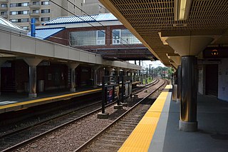
Suffolk Downs station is a rapid transit station on the Massachusetts Bay Transportation Authority (MBTA) Blue Line, located on the east side of Orient Heights in East Boston, Massachusetts, United States. It is named for the now-defunct Suffolk Downs racetrack, located just to the north. Suffolk Downs station has two side platforms, with a footbridge structure of brick, concrete, and steel connecting them. The station is accessible. With just 521 daily boardings in FY 2019, Suffolk Downs is the least-used fare-controlled station on the MBTA subway system.

Orient Heights station is a rapid transit station in Boston, Massachusetts. The station serves the MBTA Blue Line. It is located off Bennington Street in East Boston's Orient Heights neighborhood. Formerly a Boston, Revere Beach and Lynn Railroad station under various names from 1875 to 1940, it reopened in 1952. The 1952-built station was closed in March 2013 for a complete rebuilding to provide full accessibility and reopened on November 26, 2013.

Miguel Rosales is president and principal designer of Rosales + Partners, an architecture firm based in Boston, Massachusetts. He specializes in bridge aesthetics and design. Some examples of these bridges include; Phyllis J. Tilley Memorial Bridge, Christina and John Markey Memorial Pedestrian Bridge, and Liberty Bridge at Falls Park on the Reedy River.

Bellingham Square station is a Massachusetts Bay Transportation Authority (MBTA) Silver Line bus rapid transit (BRT) station located near Bellingham Square slightly north of downtown Chelsea, Massachusetts. The station has two accessible side platforms for buses on the SL3 route. The Boston and Maine Railroad and predecessor Eastern Railroad served Chelsea station at the same location from the mid-1850s to 1958. The MBTA opened Chelsea station on the Newburyport/Rockport Line in 1985. Prior to its 2010 cancellation, the Urban Ring Project planned for a circumferential BRT line with a stop at Mystic Mall. Planning continued for the Chelsea segment; a Silver Line extension to Mystic Mall was announced in 2013. Construction began in 2015, and SL3 service to the renamed Bellingham Square station began on April 21, 2018. Commuter rail service moved to the newly constructed Chelsea station on November 15, 2021.

Medford/Tufts station is a light rail station on the Massachusetts Bay Transportation Authority (MBTA) Green Line located off Boston Avenue near College Avenue in Medford, Massachusetts, adjacent to Tufts University. The accessible station has a single island platform serving the two tracks of the Medford Branch. It opened on December 12, 2022, as part of the Green Line Extension (GLX), which added two northern branches to the Green Line, and is the northern terminus of the E branch.

The Phyllis J. Tilley Memorial Bridge is a pedestrian bridge in Fort Worth, Texas. It was named in honor of Phyllis Tilley, who founded the Streams & Valleys non-profit organization dedicated to the preservation of the Trinity River.

Paul Revere Park is a five-acre (2.0 ha) park located on the Charles River in Charlestown, Massachusetts. The park was the first park to open along the "Lost Half Mile" of the Charles River as mitigation for the taking of planned parkland for the construction of the Big Dig. The park runs along the Charles River between the Freedom Trail on North Washington Street and the Leonard P. Zakim Bunker Hill Memorial Bridge. The park features a large oval-shaped lawn, an informal performance area, and a playground.


