
The Grande Dixence Dam is a concrete gravity dam on the Dixence at the head of the Val d'Hérémence in the canton of Valais in Switzerland. At 285 m (935 ft) high, it is the tallest gravity dam in the world, fifth tallest dam overall, and the tallest dam in Europe. It is part of the Cleuson-Dixence Complex. With the primary purpose of hydroelectric power generation, the dam fuels four power stations, totaling the installed capacity to 2,069 MW, generating approximately 2,000 GWh annually, enough to power 400,000 Swiss households.

Wyangala Dam is a major gated rock fill with clay core embankment and gravity dam with eight radial gates and a concrete chute spillway across the Lachlan River, located in the south-western slopes region of New South Wales, Australia. The dam's purpose includes flood mitigation, hydro-power, irrigation, water supply and conservation. The impounded reservoir is called Lake Wyangala.

Lake Margaret is a concrete-faced gravity dam with a uncontrolled spillway across the Yolande River, located on the north side of Mount Sedgwick, in the West Coast Range, West Coast of Tasmania, Australia.

Cochrane Dam is a minor earthfill embankment dam with concrete spillway across Georges Creek, located in the South Coast region of New South Wales, Australia. The main purpose of the dam is to supply water for hydro-power at the downstream Brown Mountain Power Station and for irrigation purposes. The impounded reservoir is called Cochrane Lake.

Chichester Dam is a minor concrete gravity dam across the Chichester and Wangat rivers, upstream of Dungog, in the Hunter Region of New South Wales, Australia. The dam's main purpose is water supply for the Lower Hunter region. A mini hydro-electric power station operates at times of peak flow and is connected to the national grid. The impounded reservoir is Lake Chichester.

The Mingachevir Dam is the largest hydroelectric power station in the South Caucasus, is located over Kur river and not far from Mingachevir city.

The Longyangxia Dam is a concrete arch-gravity dam at the entrance of the Longyangxia canyon on the Yellow River in Gonghe County, Qinghai Province, China. The dam is 178 metres (584 ft) tall and was built for the purposes of hydroelectric power generation, irrigation, ice control and flood control. The dam supports a 1,280 MW power station with 4 x 320 MW generators that can operate at a maximum capacity of 1400 MW. Controlling ice, the dam controls downstream releases to reservoirs lower in the river, allowing them to generate more power instead of mitigating ice. Water in the dam's 24.7 billion m3 reservoir provides irrigation water for up to 1,000,000 hectares of land.

The Yantan Dam is a gravity dam on the Hongshui River near Dahua County, Guangxi China. The main purpose of the dam is hydroelectric power production and it has an associated 1,210 MW power station consisting of 4 x 302.5 MW Francis turbine-generators.

The Wanjiazhai Dam is a gravity dam on the Yellow River on the border of Pianguan County, Shaanxi Province and Inner Mongolia Autonomous Region, China. The main purpose of the dam is water supply for the Wanjiazhai Water Control Project along with peak hydroelectric power generation. Construction on the dam began in 1994, the first generator went online in 1998 and the last in 2000.

The Votkinsk Hydroelectric Station is a dam and hydroelectric power station on the Kama River along the border of Perm Krai and Udmurtia, Russia. It is 30 km (19 mi) south of Votkinsk and its main purpose is power generation and navigation. The power station has a 1,020 MW installed capacity and the dam also supports a ship lift. Construction on the dam began in 1955, the first generator was operational in 1961 and the last in 1963. The entire project was complete in 1965.

The Ichari Dam is a concrete gravity dam on the Tons River 13 km (8 mi) north of Dakpathar in Uttarakhand, India. The primary purpose of the dam is hydroelectric power production and it is a run-of-the-river-type. It was completed in 1972. The dam diverts water to the Chibro Power Station which is then returned to the Tons River before being fed to the Khodri Power Station.

The Maneri Dam is a concrete gravity dam on the Bhagirathi River located at Maneri, 8.5 kilometres (5.3 mi) east of Uttarkashi in Uttarkashi district, Uttarakhand, India. The primary purpose of the dam is to divert water into a tunnel which feeds the 90 megawatts (120,000 hp) run-of-the-river Tiloth Power Plant.
The Imha Dam is an embankment dam on the Banbyeoncheon River, a tributary of the Nakdong River, 14 km (9 mi) east of Andong in Gyeongsangbuk-do province, South Korea. The purpose of the dam is flood control, water supply and hydroelectric power generation. Construction on the dam began in 1987 and it was complete in 1991. The 73 m (240 ft) tall rock-fill, central earth-core dam creates a reservoir with a capacity of 595,000,000 m3 (482,374 acre⋅ft) and supplies a 50 MW power station with water. It supplies water for both municipal and industrial uses to Gumi, Dagu, Masan, Changwon, Jinhae, Woolsan, and Busan.
The Andong Dam is an embankment dam on the Nakdong River, 4 km (2 mi) east of Andong in Gyeongsangbuk-do province, South Korea. The purpose of the dam is flood control, water supply and hydroelectric power generation. Construction on the dam began in 1971 and was complete in 1976. The 83 m (272 ft) tall rock-fill, central clay core dam withholds a reservoir of 1,248,000,000 m3 (1,011,770 acre⋅ft) and provides water to an 80 MW pumped-storage power station. The lower reservoir (afterbay) for the power station is created by a 20 m (66 ft) high and 238 m (781 ft) long weir.

The Daecheong Dam is a combination concrete gravity and embankment dam on the Geum River, 16 km (10 mi) north of Daejeon in South Korea. The multi-purpose dam provides benefits of flood control, water supply and hydroelectric power generation. Construction on the dam began in 1975 and was formally commissioned on 1 December 1980. The 72 m (236 ft) high rock-fill dam has a central clay core and has created a reservoir with storage of 1,490,000,000 m3 (1,207,963 acre⋅ft).

The Soyang Dam, also referred to as the Soyanggang Dam, is an embankment dam on the Soyang River, 10 km (6 mi) northeast of Chuncheon in Gangwon-do Province, South Korea. The purpose of the dam is flood control, water supply and hydroelectric power generation. Construction on the dam began in 1967 and was complete in 1973. The 123 m (404 ft) tall dam withholds a reservoir of 2,900,000,000 m3 (2,351,068 acre⋅ft) and supplies water to a 200 MW power station.
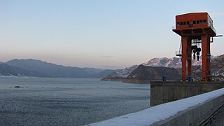
The Yangyang Pumped Storage Power Station uses the water of the Namdae-Chun River to operate a 1,000-megawatt (1,300,000 hp) pumped storage hydroelectric power scheme, about 10 kilometres (6.2 mi) west of Yangyang in Gangwon Province, South Korea. The lower reservoir is created by the Yangyang Dam on the Namdae and the upper reservoir by the Inje Dam is located 937 metres (3,074 ft) above the power plant. Construction on the power plant began in 1996 and it was completed and dedicated on September 13, 2006. It is operated by Korean Midland Power Co., a subsidiary of Korea Electric Power Company and was completed at a cost of ₩1.1 trillion won. The first generator was operational on February 23, 2006 and the last August 10, 2006.

The Okutadami Dam (奥只見ダム) is a concrete gravity dam on the Tadami River, 26 km (16 mi) east of Uonuma on the border of Niigata and Fukushima Prefectures, Japan. The primary purpose of the dam is hydroelectric power generation and it supports a 560 MW power station which is the largest conventional hydroelectric power station in Japan. The dam also forms the second largest reservoir in Japan, next to that of the Tokuyama Dam.
The Unbong Dam, or Yunfeng Dam, is a concrete gravity dam on the Yalu River which borders China and North Korea. It is located 33 km (21 mi) northeast of Ji'an in Jilin Province, China and Chasŏng in Chagang Province, North Korea. The primary purpose of the dam is hydroelectric power generation and it supports a 400 MW power station. Construction of the dam had initially began in August 1942 but was halted in 1945 after the surrender of Japan ending World War II. In October 1959, construction on the dam recommenced and in September 1965, the first of the four 100 MW Francis turbine-generators was operational. The last generator was operational on 4 April 1967. The 113.75 m (373 ft) tall dam creates a reservoir with a storage capacity of 3,895,000,000 m3 (3,157,728 acre⋅ft). The dam's spillway is an overflow type with 21 floodgates and has a maximum discharge of 21,900 m3/s (773,391 cu ft/s). The dam is located before a bend in the river and its power station is located on the other side of a ridge that meets the dam’s right abutment. Water is delivered to the power station via two tunnels, 775 m (2,543 ft) and 759 m (2,490 ft) long. Generators 1 and 3 deliver power to China while 2 and 4 deliver to North Korea.

The Deduru Oya Dam is an embankment dam built across the Deduru River in Kurunegala District of Sri Lanka. Built in 2014, the primary purpose of the dam is to retain approximately a billion cubic metres of water for irrigation purposes, which would otherwise flow out to sea. Construction of the dam began in 2006 and was ceremonially completed in 2014, with the presence of former President Mahinda Rajapaksa.


