
Red Lake County is a county in the U.S. state of Minnesota. As of the 2010 United States Census, the population was 4,089, making it the third-least populous county in Minnesota. Its county seat is Red Lake Falls.

Not to be confused with Cook, Minnesota in Saint Louis County.

Farm Island Township is a township in Aitkin County, Minnesota, United States. The population was 1,099 as of the 2010 census.

Nordland Township is a township in Aitkin County, Minnesota, United States. The population was 972 as of the 2010 census.
Benton Township is a township in Carver County, Minnesota, United States. The population was 939 as of the 2000 census.

Sauk Centre is a city in Stearns County, Minnesota, United States. The population was 4,317 at the 2010 census. It is the birthplace of Sinclair Lewis, a novelist and winner of the Nobel Prize in Literature, and Sauk Centre served as the inspiration for Gopher Prairie, the fictional setting of Lewis's 1920 novel Main Street.
Bowstring is an unincorporated community in Bowstring Township, Itasca County, Minnesota, United States.
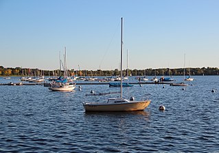
Bde Maka Ska is the largest lake in Minneapolis, Minnesota, United States, and part of the city's Chain of Lakes. Surrounded by city park land and circled by bike and walking trails, it is popular for many outdoor activities. The lake has an area of 401 acres (1.62 km2) and a maximum depth of 87 feet (27 m).

Eagle Mountain is the highest natural point in Minnesota, United States, at 2,301 feet (701 m). It is in northern Cook County, in the Boundary Waters Canoe Area Wilderness and Superior National Forest in the Misquah Hills, northwest of Grand Marais. It is a Minnesota State Historic Site.
Bachelor Lake is a lake in Brown County, Minnesota in the northeastern part of Stark township. Covering 79.80 acres, it is an officially protected water of the State of Minnesota. The lake is within the Cottonwood River Major Watershed. The lake’s elevation is 1,004 feet (306 m), and it is zoned as a shoreland area which is regulated as a shoreland management water.
Maple Bay is an unincorporated community in Godfrey Township in central Polk County, Minnesota, United States. A community of second homes and cabins, it lies on the west end of Maple Lake, approximately 6 miles west of Erskine.
Finland is an unincorporated community and census-designated place (CDP) in Crystal Bay and Beaver Bay townships, Lake County, Minnesota, United States. As of the 2010 census, its population was 195.
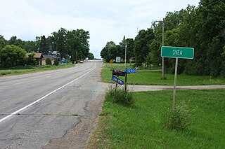
Svea is an unincorporated community, in Whitefield Township, Kandiyohi County, Minnesota, United States. The town does not appear on the U.S. Census Bureau website, but the population is roughly 100.

The following outline is provided as an overview of and topical guide to the U.S. state of Minnesota:

Rice Lake is a ghost town in Dodge and Steele counties in the U.S. state of Minnesota. It is located east of Owatonna, and just north of Rice Lake State Park. The nearest community is the city of Claremont, to the southeast. The Dodge County portion lies in the southwest corner of Ellington Township, while the Steele County portion lies in the southeast corner of Merton Township.
Ball Club is an unincorporated community and census-designated place (CDP) in Itasca County, Minnesota, United States; located within the Leech Lake Indian Reservation. As of the 2010 census, its population was 342. Ball Club is located between Zemple and Bena.
Delft is an unincorporated community located in Cottonwood County, Minnesota in Carson Township.
School Lake is a lake in Brown County, Minnesota, in the United States. It is a 102-acre protected lake.
Island Lake is an unincorporated community in Beltrami County, in the U.S. state of Minnesota.
Wall Lake is an unincorporated community in Otter Tail County, in the U.S. state of Minnesota.
