
Flushing Meadows–Corona Park is a public park in the northern part of Queens in New York City, New York, U.S. It is bounded by I-678 on the east, Grand Central Parkway on the west, Flushing Bay on the north, and Union Turnpike on the south. Flushing Meadows–Corona Park is the fourth-largest public park in New York City, with a total area of 897 acres (363 ha).

Mississauga is a Canadian city in the province of Ontario. Situated on the western shore of Lake Ontario in the Regional Municipality of Peel, it borders Toronto (Etobicoke) to the east, Brampton to the north, Milton to the northwest, and Oakville to the southwest. Although Mississauga was initially a car-centric city, significant strides have been made to improve walkability and add cycling lanes, with most major arteries having bi-directional bike lanes. The city's downtown is home to several transit hubs, such as Square One Bus Terminal, and the City Centre Transit Terminal. With a population of 717,961 as of 2021, Mississauga is the seventh-most populous municipality in Canada, third-most in Ontario, and second-most in the Greater Toronto Area (GTA) after Toronto itself. However, for the first time in its history, the city's population declined according to the 2021 census, from a 2016 population of 721,599 to 717,961, a 0.5 per cent decrease.

The Regional Municipality of Peel is a regional municipality in the Greater Toronto Area, Southern Ontario, Canada. It consists of three municipalities to the west and northwest of the city of Toronto: the cities of Mississauga and Brampton, and the town of Caledon, each of which spans its full east–west width. The regional seat is in Brampton.
King's Highway 403, or simply Highway 403, is a 400-series highway in the Canadian province of Ontario that travels between Woodstock and Mississauga, branching off from and reuniting with Highway 401 at both ends and travelling south of it through Hamilton and Mississauga. It is concurrent with the Queen Elizabeth Way (QEW) for 22 km (14 mi) from Burlington to Oakville. The Highway 403 designation was first applied in 1963 to a short stub of freeway branching off the QEW, and the entire route was completed on August 15, 1997, when the section from Brantford to the then-still independent Town of Ancaster was opened to traffic. The section of Highway 403 between Woodstock and Burlington was formally dedicated as the Alexander Graham Bell Parkway on April 27, 2016, in honour of Alexander Graham Bell.

Clarkson, also called Clarkson Village, is a neighbourhood in the city of Mississauga, Ontario, Canada, situated in the southwest corner of the city, along the shore of Lake Ontario. It is bordered by Lake Ontario to the south, Oakville to the west, Erindale and Erin Mills to the north, and Lorne Park to the east.
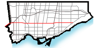
Eglinton Avenue is a major east–west arterial thoroughfare in Toronto and Mississauga in the Canadian province of Ontario. The street begins at Highway 407 at the western limits of Mississauga, as a continuation of Lower Baseline in Milton. It traverses the midsection of both cities and ends at Kingston Road. Eglinton Avenue is the only street to cross all six former cities and boroughs of Metropolitan Toronto.

Meadowvale is a large suburban district located in the northwestern part of Mississauga, Ontario, Canada, just west of Toronto. In the 19th and early 20th centuries, Meadowvale Village in Toronto Township was established nearby and named for the meadows along the Credit River. By the 1970s the village would diminish with the current area to the west selected to be the site of a "new town" for the newly (1974) incorporated City of Mississauga and took the Meadowvale name, while "Village" was added to the historic community. This newer section comprises the bulk of the district today, and runs into the Lisgar neighbourhood. Another extension of the district at Derry Road is referred to as Meadowvale West.

The Kingston Memorial Centre is a 3,300-seat multi-purpose arena located at 303 York Street in Kingston, Ontario, Canada. Opened in 1951, the Kingston Community Memorial Health and Recreation Centre was designed as a community sports and entertainment centre that would become a "living memorial" in remembrance of Kingstonians who gave their life in both world wars and the Korean War. The Memorial Centre lands and facilities include a war memorial, a large ice pad in the arena building, a new outdoor aquatic centre, agricultural barns, softball diamonds, a cinder track, off leash dog park and a linear park at the east, north and west perimeter of the property. Just east of the arena building was the International Hockey Hall of Fame (IHHOF) museum building at 277 York St. In July 2012, Kingston City Council approved the relocation of the collection on a short-term basis to the Invista Centre on Gardiners Road in Kingston. The existing building was found to have costly repair issues related to moisture penetration. It was demolished after the IHHOF moved to the Invista Centre in Kingston's west end.

Lakeview is a neighbourhood in Mississauga in the Region of Peel, centred on Lakeshore Road in the extreme southeastern corner of the city, along the shore of Lake Ontario, between the larger neighbourhood of Port Credit to the west and the Long Branch neighbourhood of Toronto to the east.

The Mississauga Transitway is a bus rapid transit (BRT) system in Mississauga, Ontario, Canada. It comprises a series of purpose-constructed bus-only roadways, as well as reserved lanes on existing city streets and portions of Highway 403, that together form a continuous 18 km (11 mi) route spanning most of the city from Winston Churchill Boulevard in the west to the junction of Highways 401 and 427 in the east on the border with Toronto. Service on the Transitway is provided by MiWay and GO Transit, with some stations providing connections to Brampton Transit and Toronto Transit Commission (TTC) bus services.

Waterfront Toronto is an organization that oversees revitalization projects along the Toronto waterfront. Established in 2001 as a public–public partnership between the City of Toronto, Province of Ontario and Government of Canada, the organization is administering several blocks of land redevelopment projects surrounding Toronto Harbour and various other initiatives to promote the revitalization of the area, including public transit, housing developments, brownfield rehabilitation, possible removal of the Gardiner Expressway in the area, the Martin Goodman Trail and lakeshore improvements, and naturalization of the Don River. Actual development of the projects is done by other entities, primarily private corporations. The projects include a series of wavedeck walkways and gathering places designed by West 8 and DTAH.

Capitol View is a historic intown southwest Atlanta, Georgia neighborhood. The neighborhood is 2.5 miles from downtown and was named for its views of the Georgia State Capitol building. Its boundaries include Metropolitan Parkway to the east, Lee Street to the west, and the Beltline to the north. On the south, the border follows Arden Street, Deckner Avenue, and Perkerson Park.
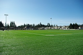
Hidden Creek Park East, formerly known as 53rd Avenue Community Park, is a municipal park in Hillsboro, Oregon, United States. Partially opened in 2008, the park covers 43.5 acres (17.6 ha) along northeast 53rd Avenue in the middle of the city. The park includes two multi-purpose sports fields covered with artificial turf along with basketball courts, tennis courts, and a water fountain. Its neighboring park, Hidden Creek Park West, contains an indoor recreation center which include exercise facilities and a gymnasium along with outdoor park items that include children's play equipment, a combined futsal/pickleball court, and walking trails. Plans call for a aquatics center to be built in the near future. Land for both parks were purchased from exercise equipment maker Soloflex beginning in 2001.

Bellevue Downtown Park is a 20-acre (81,000 m2) park located in downtown Bellevue, Washington, United States, a suburb of Seattle. The park consists of a circular ring with a large central greenspace that is surrounded by a moat and walking trails. It is situated between Bellevue Square Mall to the north, Bellevue Way to the east, and Main Street to the south.

The Hurontario LRT is a light rail line under construction in the cities of Mississauga and Brampton, Ontario, Canada. The line will run along Hurontario Street from Mississauga's Port Credit neighbourhood north to Steeles Avenue in Brampton. The line will be built and operated as a public-private partnership by Mobilinx, a consortium of private European and Japanese companies, with provincial transit agency Metrolinx retaining ownership of the line. It will be the only street railway operating in the Greater Toronto Area outside Toronto proper.

The University of Toronto Mississauga is a satellite campus of the University of Toronto. It is in Mississauga, Ontario, Canada about 33 kilometres west of the main St. George campus. It was formerly called the Erindale College but was later changed to the University of Toronto Mississauga (UTM). The campus has eight main educational buildings: the Maanjiwe nendamowinan Building, Deerfield Hall, the William G. Davis Building, the Kaneff Centre and Blackwood Gallery, the Recreation, Athletic, and Wellness Centre, the Hazel McCallion Academic Learning Centre which holds UTM's library, the Instructional Building, and the new Terrence Donnelly Health Sciences Complex for the Mississauga Academy of Medicine. The campus also houses 3 residence halls: Erindale Hall, Roy Ivor Hall, and Oscar Peterson Hall.
Churchill Meadows is a suburban residential neighbourhood located in the westernmost area of Mississauga, Ontario, Canada. In 2016, Churchill Meadows had a population of 47,800. Postal codes in this area are L5M, and area codes, are 905, and 289. It is located near Erin Mills and the Erin Mills Town Centre. A large community centre and sport park will be built in the community, known as the Churchill Meadows Community Centre.

M City Condominiums, owned by Rogers Real Estate Development (“Rogers”) and developed by Urban Capital is a master-planned high-rise condominium community located at Burnhamthorpe Road and Confederation Parkway in the city centre of Mississauga, Ontario, Canada.

Lisgar is a residential neighbourhood in the city of Mississauga, Ontario, Canada. It is located in the extreme northwestern corner of the city, bordering the larger Meadowvale district to the east and the Churchill Meadows neighbourhood to the south. It is named after the former hamlet located at the corner of Winston Churchill Boulevard and Derry Road, which is actually outside the present neighbourhood in Meadowvale.


