Carroll Plantation is a plantation in Penobscot County, Maine, United States. The plantation was named for Daniel Carroll, a signer of the United States Constitution. It is located along Maine State Route 6 near its intersection with State Route 170. The population was 153 at the 2010 census. It is part of the Bangor Metropolitan Statistical Area.
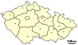
Bořice is a small village in the Pardubice Region of the Czech Republic. It has around 170 inhabitants.
Sila or Dar Sila was formerly a department in the Ouaddaï region of Chad.
The Canton of Albertville-Sud is a French former administrative subdivision, situated in the Savoie département and the Rhône-Alpes région. It was disbanded following the French canton reorganisation which came into effect in March 2015. In 1999, the population was 9,435.

Château Grimaldi at Puyricard near Aix-en-Provence is a mansion built within the ruined walls of a 16th-century Château once belonging to the Archbishops of Puyricard. The original castle chapel remains built in the Romanesque style. Between 1655 and 1685 the château served as residence of Cardinal Archbishop Girolamo Grimaldi-Cavalleroni who had rebuilt the chateau which had been in ruins for 70 years. As the residence of an archbishop the ruined Château is sometimes referred to as an episcopal palace. The term "palace" for any residence, no matter how large, other than episcopal is not commonly used in Europe for any rural building.

Łosiniec is a village in the administrative district of Gmina Susiec, within Tomaszów Lubelski County, Lublin Voivodeship, in eastern Poland. It lies approximately 10 kilometres (6 mi) east of Susiec, 10 km (6 mi) south-west of Tomaszów Lubelski, and 106 km (66 mi) south-east of the regional capital Lublin.
Pawłoszewo is a village in the administrative district of Gmina Wołów, within Wołów County, Lower Silesian Voivodeship, in south-western Poland. Prior to 1945 it was in Germany.
KCHL is an Urban Gospel radio station based in San Antonio, Texas and broadcast on 1480 AM.

Kürdüvan is a village in the Ismailli Rayon of Azerbaijan. The village forms part of the municipality of Zeyvə.
Mirzəqasım is a village in the Quba Rayon of Azerbaijan. The village forms part of the municipality of Hacıqaib.
Abdinli is a village in the Yardymli Rayon of Azerbaijan. The village forms part of the municipality of Yeni Abdinli.
Jeziory is a village in the administrative district of Gmina Łuków, within Łuków County, Lublin Voivodeship, in eastern Poland. It lies approximately 4 kilometres (2 mi) south-east of Łuków and 73 km (45 mi) north of the regional capital Lublin.
Oszczepalin Drugi is a village in the administrative district of Gmina Wojcieszków, within Łuków County, Lublin Voivodeship, in eastern Poland. It lies approximately 7 kilometres (4 mi) east of Wojcieszków, 19 km (12 mi) south of Łuków, and 57 km (35 mi) north of the regional capital Lublin.
Jeziernia is a village in the administrative district of Gmina Tomaszów Lubelski, within Tomaszów Lubelski County, Lublin Voivodeship, in eastern Poland.
Lisiny is a village in the administrative district of Gmina Lubowidz, within Żuromin County, Masovian Voivodeship, in east-central Poland.
Stefanowo is a village in the administrative district of Gmina Sompolno, within Konin County, Greater Poland Voivodeship, in west-central Poland.
Pawłów is a village in the administrative district of Gmina Nowe Skalmierzyce, within Ostrów Wielkopolski County, Greater Poland Voivodeship, in west-central Poland.

Gornje Štitarevo is a village in the municipality of Višegrad, Bosnia and Herzegovina.

West Ukrainian University of Economics and Law is a Ukrainian University in Ivano-Frankivsk.


