
Hamburg is a town in Marathon County, Wisconsin, in the United States. It is part of the Wausau, Wisconsin Metropolitan Statistical Area. As of the 2010 census, the town had a population of 918. The unincorporated communities of Hamburg and Little Chicago are located within the town.

Rocky Comfort is an unincorporated community in northeastern McDonald County, Missouri, United States, on Route 76. It is part of the Fayetteville–Springdale–Rogers, AR-MO Metropolitan Statistical Area.
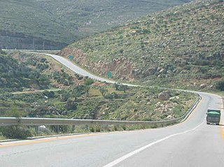
Allon Road is the name given by Israel to Routes 458, 508, and 578 in the West Bank, running roughly south–north along the eastern watershed of the Judaean and Samarian Hills, between Highway 1 near Kfar Adumim east of Jerusalem and Highway 90 at Mehola in the central Jordan Valley.

The Usuki Stone Buddhas are a collection of stone sculptures of Buddhas, in Usuki, Ōita Prefecture, Japan.

Barry Township is located in Pike County, Illinois. As of the 2010 census, its population was 1,675 and it contained 791 housing units.
Vicksburg is an unincorporated community in Wright Township, Greene County, Indiana.

Mott Station is an unincorporated community in Jackson Township, Harrison County, Indiana.

Nor Kyurin is a village in the Ararat Province of Armenia. Nor Kyurin means New Kyurin, pronounced [gjurin] or [gyrin] in Western Armenian. It was named after the city of Gürün, which is known as Gurin or Gyurin to Armenians, was a part of historical Pokr Hayk and had a significant Armenian population until the Armenian genocide.
Yuxarı Veysəlli is a village in the Fuzuli District of Azerbaijan. It was under the occupation of the Armenian forces of the self-proclaimed Republic of Artsakh since the First Nagorno-Karabakh war, until its recapture by the Azerbaijan Army on November 7 2020, during the 2020 Nagorno-Karabakh war.
Cygan is a village in the administrative district of Gmina Lubochnia, within Tomaszów Mazowiecki County, Łódź Voivodeship, in central Poland. It lies approximately 8 kilometres (5 mi) south of Lubochnia, 7 km (4 mi) north-east of Tomaszów Mazowiecki, and 51 km (32 mi) south-east of the regional capital Łódź.
Oskardów is a settlement in the administrative district of Gmina Warka, within Grójec County, Masovian Voivodeship, in east-central Poland.
Cupel is a village in the administrative district of Gmina Serock, within Legionowo County, Masovian Voivodeship, in east-central Poland.
Krasna-Kolonia is a village in the administrative district of Gmina Huszlew, within Łosice County, Masovian Voivodeship, in east-central Poland.
Bębina is a settlement in the administrative district of Gmina Jutrosin, within Rawicz County, Greater Poland Voivodeship, in west-central Poland.

Nový Dům is a village and municipality in Rakovník District in the Central Bohemian Region of the Czech Republic.
Kolleram is a village and rural commune in the Mirriah Department of the Zinder Region of Niger.
Monte Scanapà is a mountain of Lombardy, Italy. It is located within the Bergamo Alps.
Welchs is an unincorporated community in Caroline County, in the U.S. state of Virginia.

Varangu is a village in Väike-Maarja Parish, Lääne-Viru County, in northeastern Estonia.

Torre del Arroyo del Lobo is a ruined medieval defensive tower near Algeciras, Spain. It is located in the cove of Getares, and monitored the stretch of coast from Punta Carnero to Punta de San García between the cities of Algeciras and Tarifa as part of the defensive system of the Strait of Gibraltar in the Middle Ages.
