
Cathedral Rock is a national park 8 kilometres (5.0 mi) west of Waterfall Way in New South Wales, Australia, 70 kilometres (43 mi) east of Armidale and about 555 kilometres (345 mi) north of Sydney.

Nathia Gali or Nathiagali is a hill station and mountain resort town located in the Abbottabad District of Khyber Pakhtunkhwa, Pakistan. It is located at the centre of the Galyat range, where several hill stations are situated. Nathia Gali is known for its scenery, hiking trails and weather, which is much cooler than the rest of the Galyat range due to it being at a higher altitude. It is situated approximately 32 kilometres (20 mi) away from both Murree and Abbottabad.

Parikrama or Pradakshina is clockwise circumambulation of sacred entities, and the path along which this is performed, as practiced in the Indic religions – Hinduism, Buddhism, Sikhism and Jainism. In Buddhism, it refers only to the path along which this is performed. Typically, in Indic-religions the parikrama is done after completion of traditional worship and after paying homage to the deity. Parikrama must be done with dhyāna.
The Murree Rebellion of 1857 was a part of the Indian Rebellion of 1857. It was a skirmish between the hill tribes of Murree and the colonial government of British India. Resentment toward colonial rule had been mounting for many years following the establishment of British Raj in the subcontinent. There had been occasional isolated uprisings toward the British. The significance of the 1857 events was that, although not centrally coordinated, the uprisings had the feel of something much larger with real anticipation that colonial rule would be overthrown.
Kohala is a town in Pakistan on the River Jhelum, north of Murree, south of Muzaffarabad, and east of Bagh. The town was at the independence of Pakistan in 1947 a border town between newly created Pakistan and the princely state of Jammu and Kashmir, but is today only the border between the rest of Pakistan and Azad Kashmir.

Mandai is a planning area located in the North Region of Singapore, famously known for being the access point for the Mandai Wildlife Reserve which includes the Singapore Zoo, Night Safari, River Wonders, Bird Paradise and Rainforest Wild.

Mushkpuri, Mukshpuri, or Mukeshpuri is a 2,800-metre-high (9,200 ft) mountain in the Nathia Gali Hills, in the Circle Bakote Region of Abbottabad District of the Khyber Pakhtunkhwa province in northern Pakistan. It is 90 kilometres (56 mi) north of Islamabad, just above Dunga Gali in the Nathia Gali area of Ayubia National Park. It is the second highest peak in the Galyat Region after Miranjani which is located at 2,992 metres (9,816 ft). Much of the mountain is covered with Western Himalayan subalpine conifer forests.

Glantane East is a megalithic complex situated 6.4 kilometres (4.0 mi) from Millstreet, County Cork, Ireland. It is set in the Keel River valley on the north-west upper slopes of Musherabeg mountain, in the townland of Glantane. The complex includes a wedge tomb, two stone circles and a pair of stone alignments.

Birote Kalan is one of the 51 union councils of Abbottabad District in the Khyber-Pakhtunkhwa province of Pakistan.

The Downtown Line (DTL) is a medium-capacity Mass Rapid Transit (MRT) line in Singapore. It runs from Bukit Panjang station in the north-west of the country towards Expo station in the east via a loop around the city-centre. Coloured blue on the rail map, the line serves 34 stations, all of which are underground. The DTL is the fifth MRT line on the network to be opened and the third line to be entirely underground. It is the second MRT line to be operated by SBS Transit after the North East Line. It also serves as an alternative to the East–West Line where it runs roughly geographically parallel from Bugis to Expo station.
Moolia is a village of Abbottabad District in Khyber Pakhtunkhwa province of Pakistan. It is part of Bakot Union Council and is located in the east of the district. It was impacted by the 2005 earthquake.

The Coatzacoalcos is a large river that feeds mainly the south part of the state of Veracruz; it originates in the Sierra de Niltepec and crosses the state of Oaxaca in the region of the Isthmus of Tehuantepec, flowing for 325 kilometres toward the Gulf of Mexico. Tributaries include El Corte, Sarabia, Jaltepec, Chalchijalpa, El Chiquito, Uxpanapa, and Calzadas. The merging of all these rivers creates one of the largest current flows in the entire region. Two-thirds of the streams are navigable.
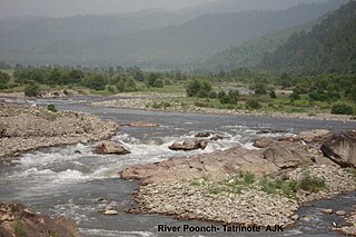
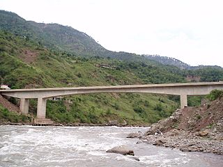
The Poonch River is a tributary of the Jhelum River that flows through Jammu and Kashmir in India, and Jammu and Kashmir in Pakistan.
Surankote is a town in the Surankote Tehsil of the Poonch district of the Indian union territory of Jammu and Kashmir. It occupies the Surankote valley, located between the Pir Panjal and ranges within the Himalayas. It receives snowfall in winters. It is famous for the existence of lakes on the Pir Panjal range which are not still connected with the outside world. Although some people visit these lakes by foot for recreation and refreshment.

Abbaspur commanly known as Bandi or Bandi Abbaspur is a Tehsil located near line of control which divides Pakistan administered Kashmir and Indian administered Kashmir. It used to be called Gaopalpur before its name was changed. The tensil is made up of different areas, every thing above the abbaspur city. the mountain facing toward the city in front of it and up to mehmood gali is called Tangyran. the mountain side facing toward the Poonch river or Rangard between Abbaspur and Potha is called Choyi, It is the sub-divisional headquarters of district, Rawalakot, Poonch, Azad Kashmir.
Bhimber Gali is a village in the Poonch district of Jammu and Kashmir, India. It is often called BG locally as an abbreviated form of Bhimber Gali. It is named after a mountain pass "Bhimber Gali" on the mountain ridge separating the Poonch River and the Rajouri Tawi basins. Bhimber Gali is the point at which four roads meet, one from Hamirpur Balakote, second from Rajouri via Manjakote, third from Mendhar Tehsil and fourth from Poonch Via Surankote. This area borders Pakistan administered Kashmir and thus the surrounding areas often remain in news for cross LoC ceasefire violations.
Pīr Kanthi is located in Bagh District, Azad Kashmir, in the mountains of the Pir Panjal Range. It is estimated to be 3,243 metres above sea level.

Samote Union Council is a union council in Punjab, Pakistan.

The Tulail Valley is a Himalayan sub-valley of Gurez in the union territory of Jammu and Kashmir in India. The Valley lies 120 kilometres (75 mi) northeast of Bandipora and 200 kilometres (120 mi) from Srinagar the summer capital of Jammu and Kashmir. Tulail Valley lies immediate east of the Gurez Valley.
The Saskatoon Freeway is a proposed four-lane limited access highway in and adjacent to Saskatoon, Saskatchewan. The 55-kilometre (34 mi) route will connect Highway 11 (south) with Highway 7, forming a partial ring road around the city of Saskatoon. When complete, it will serve as a replacement bypass route for the existing Circle Drive.
