
The Circle Bar is a famous, historic bar and lounge on Main Street in Santa Monica, California, United States. [1] It was established in 1949. [2] Movieline named it one of the 10 best places for young actors to be seen at night.[ citation needed ]
The Circle Bar is a famous, historic bar and lounge on Main Street in Santa Monica, California, United States. [1] It was established in 1949. [2] Movieline named it one of the 10 best places for young actors to be seen at night.[ citation needed ]
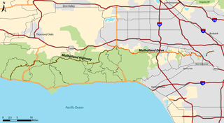
Mulholland Drive is a street and road in the eastern Santa Monica Mountains of Southern California. It is named after pioneering Los Angeles civil engineer William Mulholland. The western rural portion in Los Angeles and Ventura Counties is named Mulholland Highway. The road is featured in a significant number of films, songs, and novels. David Lynch, who wrote and directed a film named after Mulholland Drive, has said that one can feel "the history of Hollywood" on it. Jack Nicholson has lived on Mulholland Drive for many years, and still did so as of 2009.

Original Tommy's, previously known as Original Tommy's World Famous Hamburgers, is a fast food hamburger restaurant chain in the Los Angeles metropolitan area. It is known for its hamburgers and chili burgers.

Barney's Beanery is a chain of gastropubs in the Greater Los Angeles Area. John "Barney" Anthony founded it in 1920 in Berkeley, California, and in 1927 he moved it to U.S. Route 66, now Santa Monica Boulevard, in West Hollywood. As of 2011, Barney's Beanery had locations in Burbank, Pasadena, Santa Monica, Westwood, Redondo Beach at the Redondo Beach Pier and the original in West Hollywood.

Santa Monica Bay is a bight of the Pacific Ocean in Southern California, United States. Its boundaries are slightly ambiguous, but it is generally considered to be the part of the Pacific within an imaginary line drawn between Point Dume, in Malibu, and the Palos Verdes Peninsula. Its eastern shore forms the western boundary of the Los Angeles Westside and South Bay regions. Although it was fed by the Los Angeles River until the river's catastrophic change of course in 1825, the only stream of any size now flowing into it is Ballona Creek. Smaller waterways draining into the bay include Malibu Creek, Topanga Creek, and Santa Monica Creek.

Sunset Junction is an informal name for a portion of the Silver Lake district of Los Angeles, California. It was home to the Sunset Junction Street Fair from 1980 through 2010. It is in the southwestern part of the district along Sunset Boulevard.

The Third Street Promenade is a pedestrian mall esplanade, shopping, dining and entertainment complex in the downtown area of Santa Monica, California which originally opened as the Santa Monica Mall on November 8, 1965. It is considered a premier shopping and dining district on the Westside and draws crowds from all over the Greater Los Angeles area. Due to easy access to Downtown Los Angeles via the Big Blue Bus rapid transit service, E Line's terminus station and the Pacific Coast Highway-Santa Monica Freeway Interstate, the neighborhood's north-south thoroughfares connecting to Muscle Beach, Venice Canal Historic District, Marina del Rey, Ballona Wetlands and Los Angeles International Airport, and its proximity to historic U.S. Route 66, Santa Monica Pier, Palisades Park, Tongva Park, Santa Monica State Beach and the Pacific Ocean coupled with Los Angeles's mild mediterranean climate, it is also a popular tourist destination.

California's 38th congressional district is a congressional district in the U.S. state of California based in suburban eastern Los Angeles County and Orange County, California. The district is currently represented by Democrat Linda Sánchez.
Lincoln Boulevard is a major northwest–southeast boulevard near Santa Monica Bay in Los Angeles County in California. Over 8 miles (13 km) in length, it connects Los Angeles International Airport (LAX) with Santa Monica. A portion of Lincoln Boulevard is signed as part of California State Route 1, making it a major route to go along the Pacific Coast in Los Angeles.

Centinela Avenue is a 10.2 mile major street in the Westside region of Los Angeles County, California.

Mid-City West is an area in the western part of Central Los Angeles that is served by the Mid City West Neighborhood Council. It contains the neighborhoods of Beverly–Fairfax, Beverly Grove, Burton Way, Carthay Circle, Melrose, Miracle Mile and Park La Brea.
The Little Lake City School District is a small K-8 public school district in Los Angeles County, California. As of 2005, LLCSD serves about 4,900 students.
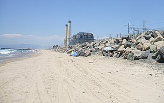
El Porto Beach is a California public beach managed by the County of Los Angeles, located in Santa Monica Bay beside El Porto, which is now part of the City of Manhattan Beach, between the beaches of El Segundo Beach and Manhattan Beach, and is protected under the state park system. The entrance to El Porto's large parking lot, which has meters, is at the west end of 45th Street from Highland Avenue.

Bergamot Station Arts Center is a Santa Monica facility housing many different private art galleries and appears in most tourist guides as a primary cultural destination. Opened September 17, 1994 as Bergamot Station the campus-like complex is owned by the city of Santa Monica and presently managed by the Worthe Group.

Founded in 1915, the Greater Los Angeles Area Council (GLAAC) (#033) served most of the City of Los Angeles as well as several other cities in the greater Los Angeles area. It was one of five Boy Scouts of America councils in Los Angeles County, California. Since its founding in 1915, the Los Angeles Area Council has brought its purpose and values to millions of youth. The Council served 54,567 youth in the Greater Los Angeles Area in 2008 alone.

The Conejo Grade is a 7% grade incline on a section of US 101. Also known as the Camarillo Grade, it links Thousand Oaks and cities of the Conejo Valley, with Camarillo and the cities on the Oxnard Plain. With a summit elevation of 841.1 feet (256.4 m), California Highway Patrol inspection stations for trucks are situated on both sides of the highway at the upper terminus of the grade.
72 Market Street Oyster Bar and Grill was a popular Venice, California restaurant founded in 1983 and launched by Tony Bill and Dudley Moore. The small restaurant was a celebrity hot spot which received attention for its food as well as an in house radio talk show and lecture series. It closed in November 2000.

Circle X Ranch is a park unit located in the Triunfo Pass within the southwestern Santa Monica Mountains National Recreation Area, in Ventura County, California. It is located in the western Santa Monica Mountains.

Wilcox Avenue is a major avenue of Los Angeles, running north–south through Hollywood, to the west of Cahuenga Boulevard. It begins to the north of Franklin Avenue from North Cahuenga Boulevard, and then runs south, crossing Sunset Boulevard, Santa Monica Boulevard and Melrose Avenue. The avenue grew primarily as an affluent residential road in the early 20th century, with the building of expensive luxury apartments. Silent actress Rosemary Theby once lived at 1907 Wilcox Avenue. The Mark Twain Hotel, a white stucco hotel named after writer Mark Twain, is located at 1622 Wilcox and was recently (2016) restored and converted into a boutique inn. There are several bars and restaurants including Paladar, a Cuban restaurant and bar at 1651 Wilcox Avenue, and The Nacional, a Havana-style cocktail bar next door at 1645. 1626 North Wilcox Avenue is the location of a company known as Hollywood Mail which rents hundreds of physical addresses for those who wish to make it appear that their business is actually located at that address.
The Dolores Del Rio House at 757 Kingman Avenue is a house in Pacific Palisades, Los Angeles, that was designed for the Mexican actress Dolores del Río and her husband, the production designer Cedric Gibbons, by Douglas Honnold and George Vernon Russell in 1929.
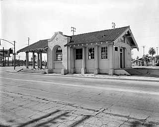
The Lynwood Pacific Electric Railway Depot is a former railway station of the Pacific Electric Railway, located in Lynwood, California. Originally in service on the Santa Ana Line, the station building was moved after the construction of the Century Freeway and now resides in downtown Lynwood.
33°59′56″N118°28′51″W / 33.998828°N 118.480696°W
| | This California-related article is a stub. You can help Wikipedia by expanding it. |