
Limestone County is a county of the U.S. state of Alabama. As of the 2020 census, the county's population was 103,570. Its county seat is Athens. The county is named after Limestone Creek. Limestone County is included in the Huntsville, AL Metropolitan Statistical Area.

Piedmont is a city in Calhoun and Cherokee counties in the U.S. state of Alabama. The population was 4,400 at the 2020 census. It is included in the Anniston-Oxford, Alabama Metropolitan Statistical Area.

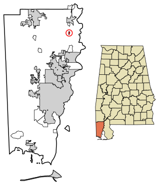
Citronelle is a city on the northern border of Mobile County, Alabama, United States. At the 2020 census, the population was 3,946. It is included in the Mobile metropolitan statistical area and is about 34 miles (55 km) north of Mobile.
Monte Sano Mountain is a mountain located in Huntsville, Alabama. The name Monte Sano is Spanish for "Mountain of health". This name comes from the fact that curative health resorts used to be located on the mountain to take advantage of the fresh air, clean water, and cooler temperatures.
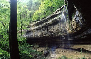
Monte Sano State Park is a public recreation area and mountaintop retreat encompassing 2,140 acres (870 ha) on the eastern portion of the top and slopes of Monte Sano Mountain on the east side of Huntsville, Alabama. The state park has 1930s-era, Civilian Conservation Corps–built rustic cottages, hiking trails and picnic areas with scenic overlooks, and modern campsites. It is managed by the Alabama Department of Conservation and Natural Resources.

Lake Guntersville State Park is a public recreation area located on the far north side of the city of Guntersville in Marshall County, Alabama. The state park occupies 5,909 acres (2,391 ha) on the eastern shore of Guntersville Lake, a 69,000-acre (28,000 ha) impoundment of the Tennessee River. The park features resort facilities and is managed by the Alabama Department of Conservation and Natural Resources.
The Alabama, Tennessee and Northern Railroad was a short line railroad which operated in the state of Alabama. The company grew from an acquisition of an existing logging railroad in 1897, and merged with the St. Louis–San Francisco Railway in 1971. The company was also known as the "Port of Mobile Route."

The Mobile and Ohio Railroad was a railroad in the Southern U.S. The M&O was chartered in January and February 1848 by the states of Alabama, Kentucky, Mississippi, and Tennessee. It was planned to span the distance between the seaport of Mobile, Alabama and the Ohio River near Cairo, Illinois. On September 13, 1940 it was merged with the Gulf, Mobile and Northern Railroad to form the Gulf, Mobile and Ohio Railroad.
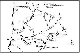
The Bartram Trail follows the approximate route of 18th-century naturalist William Bartram’s southern journey from March 1773 to January 1777. Bartram explored much of the territory which is now the states of North and South Carolina, Georgia, Florida, Alabama, Mississippi, Louisiana and Tennessee.
Bucks is an unincorporated community and census-designated place (CDP) in Mobile County, Alabama, United States. As of the 2020 census, its population was 22, down from 32 at the 2010 census. It is located in the northeastern section of the county near the Mobile River, along U.S. Route 43. The James M. Barry Electric Generating Plant, a coal- and natural gas-fired power station operated by Alabama Power, is located in Bucks.

The Gulf, Mobile and Ohio Passenger Terminal is a historic train station in Mobile, Alabama, United States. Architect P. Thornton Marye designed the Mission Revival style terminal for the Mobile and Ohio Railroad. It was completed in 1907 at a total cost of $575,000. The Mobile and Ohio merged with the Gulf, Mobile and Northern Railroad in 1940 to form the Gulf, Mobile and Ohio Railroad.

Chunchula is an unincorporated community and census-designated place (CDP) in Mobile County, Alabama, United States. As of the 2020 census, its population was 195. It has a post office with the 36521 ZIP code. The community has one site listed on the Alabama Register of Landmarks and Heritage, the Chunchula School.

Axis is an unincorporated community and census-designated place (CDP) in Mobile County, Alabama, United States. As of the 2020 census, it had a population of 561, down from 757 at the 2010 census. It has a post office with the 36505 ZIP code. The community has one site listed on the Alabama Register of Landmarks and Heritage, the Kirk House.

The Citronelle Railroad Historic District is a historic district in Citronelle, Alabama, United States. It is roughly bounded by Centre and Main streets from Union to Faye streets. The district covers 42.3 acres (0.171 km2) and contains 28 contributing properties. It was placed on the National Register of Historic Places on January 25, 1990.
Cumberland Valley Rail Trail (CVRT) is a National Recreation Trail rail trail that follows the former Cumberland Valley Railroad rail corridor for 9.5 miles, from Shippensburg to Newville, through the farmlands of western Cumberland County in south-central Pennsylvania.

The Conewago Recreation Trail is a public recreational rail trail that follows the once Cornwall-Lebanon Railroad rail corridor for a total of slightly over 5.0 miles. The trail stretches from Elizabethtown, PA to the Lebanon County Line, PA, at which point it links up to the Lebanon Valley Rail Trail which continues for another 15.0 miles. The Conewago Recreation Trail runs adjacent to the Conewago Creek running through quiet farmland and forested areas.
The Underground Railroad Bicycle Route is a 2,000-mile bicycle touring route from Mobile, Alabama, to Owen Sound, Ontario. It was developed by Adventure Cycling Association with the Center for Minority Health at the University of Pittsburgh. The route was built to loosely follow the Underground Railroad, the network of paths that African American slaves used to escape to the Northern United States and Canada.

The Tanglefoot Trail is an asphalt-covered rail trail in northeastern Mississippi. Ranging 43.6 miles (70.2 km) in the right-of-way of the Ripley and New Albany Railroad, it is the longest rail-trail in the state. It runs through three counties and is located within the Mississippi Hills National Heritage Area.

The Chattahoochee Valley Railroad Trail, sometimes referred to as the CVRR Trail, is a 7.5-mile long asphalt-covered rail trail in Valley, Alabama. Made from a section of the defunct Chattahoochee Valley Railway, the trail runs through all four historic districts of the town. These districts were formerly separate towns that were serviced by the railroad. These towns later combined to form the town of Valley in 1980.
The City of Foley Antique Rose Trail, also known as the Wilbourne Antique Rose Trail, or just the Antique Rose Trail is a one-mile long asphalt-covered rail trail in Foley, Alabama. Opened in 2007, it passes through downtown Foley and features many different types of roses along the trail. It was designated as a National Recreation Trail in 2011.


