
Launceston is a city in the north of Tasmania, Australia, at the confluence of the North Esk and South Esk rivers where they become the Tamar River (kanamaluka). As of 2021, the Launceston urban area has a population of 90,953. Launceston is the second most populous city in Tasmania after the state capital, Hobart. As of 2020, Launceston is the 18th largest city in Australia. Launceston is the fifth-largest inland city and the ninth-largest non-capital city in Australia. Launceston is regarded as the most livable regional city, and was one of the most popular regional cities to move to in Australia from 2020 to 2021. Launceston was named Australian Town of the Year in 2022.
The history of Tasmania begins at the end of the Last Glacial Period when it is believed that the island was joined to the Australian mainland. Little is known of the human history of the island until the British colonisation of Tasmania in the 19th century.
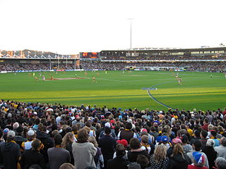
York Park is a sports ground in the Inveresk and York Park Precinct, Launceston, Australia. Holding 19,500 people, York Park is known commercially as University of Tasmania (UTAS) Stadium and was formerly known as Aurora Stadium under a previous naming rights agreement signed with Aurora Energy in 2004. Primarily used for Australian rules football, its record attendance of 20,971 was set in June 2006, when Hawthorn Football Club played Richmond Football Club in an Australian Football League (AFL) match.
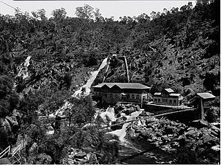
Duck Reach Power Station was the first publicly owned hydro-electric plant in the Southern Hemisphere, and provided the Tasmanian city of Launceston with hydro-electric power from its construction in 1895 to its closure in 1955.

Caveside is a rural locality in the local government area of Meander Valley in the Launceston region of Tasmania. The locality is about 45 kilometres (28 mi) south-west of the town of Westbury. It lies between the Great Western Tiers to the south and Mole Creek to the north. The 2016 census has a population of 133 for the state suburb of Caveside.

Carrick is a small historic village 17 kilometres (11 mi) west of Launceston, Tasmania, Australia, on the banks of the Liffey River. The Meander Valley Highway passes through the town's centre; this road was formerly the main road from Launceston to Deloraine and Devonport. Carrick has a well-preserved 19th-century heritage; fifteen of its colonial buildings are listed on the Tasmanian Heritage Register including Carrick House (1840), St Andrew's Church (1848), the Old Watch house (1837), Monds Roller Mill (1846) and the Carrick Hotel (1833).

Evandale is an historic town in northern Tasmania, Australia. It sits on the banks of the South Esk River, 18 km south of Launceston. Named after early colonial explorer and Surveyor-General George Evans, the town is famous for its late-Georgian and early-Victorian buildings with relatively untouched streetscape, a popular Sunday market and as a host to the annual World Penny Farthing bicycle Championships. At the 2016 census, Evandale had a population of 1,345.
Government House, Hobart, is the home and official residence of the governor of Tasmania, Australia. The palatial house is located on Lower Domain Road in the Queens Domain, near the Royal Tasmanian Botanical Gardens. There have been three Government Houses, all in Hobart.

Mole Creek is a town in the upper Mersey Valley, in the central north of Tasmania, Australia. Mole Creek is well known for its honey and accounts for about 35 percent of Tasmania's honey production. The locality is in the Meander Valley Council area, but with about 3% in the Kentish Council LGA.

The Tasmanian Government Railways (TGR) was the former operator of the mainline railways in Tasmania, Australia. Formed in 1872, the railway company was managed by the Government of Tasmania, and existed until absorption into the Australian National Railways Commission in 1978.

The Royal Society of Tasmania (RST) was formed in 1843. It was the first Royal Society outside the United Kingdom, and its mission is the advancement of knowledge.
The Queen Victoria Museum and Art Gallery (QVMAG) is a museum located in Launceston, Tasmania, Australia. The QVMAG is the largest museum in Australia not located in a capital city.

The Tasmanian Museum and Art Gallery (TMAG) is a museum located in Hobart, Tasmania. The museum was established in 1846, by the Royal Society of Tasmania, the oldest Royal Society outside England. The TMAG receives 400,000 visitors annually.

The Albert Hall is a convention centre in Launceston, Tasmania in the style of high Victorian architecture, first opened as the main structure for the Tasmanian Industrial exhibition which ran from 25 November 1891 to 22 March 1892. It is located on the corner of Tamar Street and Cimitiere Street. It was first listed on the Register of the National Estate on 21 March 1978.

Hagley is a rural locality and town in the local government area of Meander Valley in the Launceston region of Tasmania. The locality is about 5 kilometres (3.1 mi) north-east of the town of Westbury. The 2016 census has a population of 335 for the state suburb of Hagley.

Prince's Square is a park in Launceston, Tasmania, Australia. Established in 1858 from a disused brickfield it is now an important part of cultural life in Launceston and also a heritage park. The park is known for its symmetrical planning and the bronze gilded Val d'Osne Fountain. The park is bound on all four sides by Elizabeth Street, St John Street, Frederick Street and Charles Street.
Chudleigh is a rural locality in the local government area of Meander Valley in the Launceston region of Tasmania. The locality is about 37 kilometres (23 mi) west of the town of Westbury. The 2016 census has a population of 203 for the state suburb of Chudleigh.
The Tasmanian Heritage Register is the statutory heritage register of the Australian state of Tasmania. It is defined as a list of areas currently identified as having historic cultural heritage importance to Tasmania as a whole. The Register is kept by the Tasmanian Heritage Council within the meaning of the Tasmanian Historic Cultural Heritage Act 1995. It encompasses in addition the Heritage Register of the Tasmanian branch of the National Trust of Australia, which was merged into the Tasmanian Heritage Register. The enforcement of the heritage's requirements is managed by Heritage Tasmania.
The Newnham campus of the Australian Maritime College is a heritage-listed university campus at 100 Newnham Drive, Newnham, Tasmania, Australia. It was formerly a prominent pastoral estate known as Newnham Estate. It was added to the Australian Commonwealth Heritage List on 22 June 2004.

Christ Church and Milton Hall are adjacent 19th-century buildings with significance in the early religious and secular history of Launceston, Tasmania. Both buildings are located on Frederick Street, near Prince's Square.


