
The River Derwent is a river located in Tasmania, Australia, also known by the palawa kani name timtumili minanya. The river rises in the state's Central Highlands at Lake St Clair, and descends more than 700 metres (2,300 ft) over a distance of more than 200 kilometres (120 mi), flowing through Hobart, the state's capital city, before emptying into Storm Bay and flowing into the Tasman Sea. The banks of the Derwent were once covered by forests and occupied by Aboriginal Tasmanians. European settlers farmed the area and during the 20th century many dams were built on its tributaries for the generation of hydro-electricity.

Launceston is a city in the north of Tasmania, Australia, at the confluence of the North Esk and South Esk rivers where they become the Tamar River (kanamaluka). As of 2021, the Launceston urban area has a population of 90,953. Launceston is the second most populous city in Tasmania after the state capital, Hobart. As of 2020, Launceston is the 18th largest city in Australia. Launceston is the fifth-largest inland city and the ninth-largest non-capital city in Australia. Launceston is regarded as the most livable regional city, and was one of the most popular regional cities to move to in Australia from 2020 to 2021. Launceston was named Australian Town of the Year in 2022.
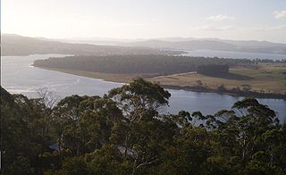
The Tamar River, officially kanamaluka / River Tamar, is a 70-kilometre (43-mile) estuary located in northern Tasmania, Australia. Despite being called a river, the waterway is a brackish and tidal estuary over its entire length.

Keepit Dam is a major gated mass concrete gravity dam with an earth fill abutment and a central gated concrete overflow crest and six radial gate spillways across the Namoi River upstream of its junction with the Peel River in the North West Slopes region of New South Wales, Australia. The dam's purpose includes flood mitigation, hydro-power, irrigation, water supply and conservation. The impounded reservoir is called Lake Keepit.

The Meander River is a major perennial river located in the central northern region of Tasmania, Australia. Until the founding of Westbury in the early 1820s, the river was known as The Western River.
The Great Lake, officially yingina / Great Lake, is a natural lake and man-made reservoir that is located in the central northern region of Tasmania, Australia.

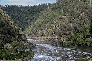
The Cataract Gorge is a river gorge in Launceston, Tasmania, Australia, approximately 1.5 km from the city centre. It is one of the region's premier tourist attractions with a Cataract Gorge boat trip leaving from Home Point Parade. It is found at the lower section of the South Esk River.
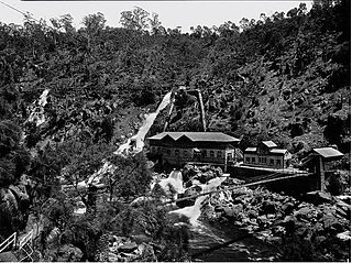
Duck Reach Power Station was the first publicly owned hydro-electric plant in the Southern Hemisphere, and provided the Tasmanian city of Launceston with hydro-electric power from its construction in 1895 to its closure in 1955.

Sheffield is a town 23 kilometres (14 mi) inland from Devonport, a city on the north-west coast of Tasmania. Sheffield has long been the rural hub for the Mount Roland area. The Sheffield area is well known for its high quality butterfat production via dairy farming. The district is also suitable for lamb and beef production. The town of Railton is nearby. At the 2021 census, Sheffield had a population of 1,602.
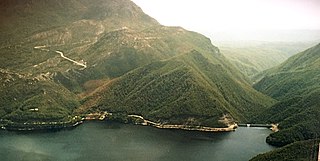
The Crotty Dam, also known during construction as the King Dam, or the King River Dam on initial approval, is a rockfill embankment dam with a controlled and uncontrolled spillway across the King River, between Mount Jukes and Mount Huxley, located in Western Tasmania, Australia.
The South Esk River, the longest river in Tasmania, is a major perennial river located in the northern region of Tasmania, Australia.

The Wivenhoe Dam is a rock and earth-fill embankment dam with a concrete spillway across the Brisbane River in South East Queensland, Australia. The dam takes it names from the local Wivenhoe Pocket rural community. The dam wall is located about 80 kilometres (50 mi) by road from the centre of Brisbane. The primary purpose of the dam is the supply of potable water for the Brisbane and Ipswich regions. The dam also provides for flood mitigation control, hydroelectricity, and recreation. The impounded reservoir is called Lake Wivenhoe and the dam, the lake and a narrow strip of surrounding land forms a locality also called Lake Wivenhoe.

The electoral division of Launceston is one of 15 electorates or seats in the Tasmanian Legislative Council, created in 2008. It also previously existed until 1999, when it was abolished and substantially incorporated into the new division of Paterson, which was in turn abolished in 2008.

The Trevallyn Power Station is a run-of-the-river hydroelectric power station located in the northern Midlands region of Tasmania, Australia. The power station is situated on the Great Lake and South Esk catchment and is owned and operated by Hydro Tasmania.

Trevallyn is a residential locality in the local government areas (LGAs) of Launceston (25%) and West Tamar (75%) in the Launceston LGA region of Tasmania. The locality is about 3 kilometres (1.9 mi) west of the city of Launceston. The 2016 census recorded a population of 4562 for the state suburb of Trevallyn. It is a suburb of Launceston.

Split Rock Dam is a minor ungated concrete faced rock fill embankment dam with concrete chute spillway across the Manilla River upstream of Manilla in the north-western slopes region of New South Wales, Australia. The dam's purpose includes flood mitigation, irrigation, water supply and conservation. The impounded reservoir is called Split Rock Reservoir.
Pindari Dam is a minor concrete faced rockfill embankment dam with an ungated uncontrolled rock cut with concrete sill spillway across the Severn River located upstream of the town of Ashford, in the North West Slopes region of New South Wales, Australia. The dam's purpose includes flood mitigation, hydro-power, irrigation, water supply and conservation. The impounded reservoir is called Lake Pindari.
The Borumba Dam is a rock-fill embankment dam with an un-gated spillway located across the Yabba Creek, a tributary of the Mary River, in the Wide Bay–Burnett region of Queensland, Australia. The main purposes of the dam are for irrigation and potable water supply. The resultant impounded reservoir is called Lake Borumba.

The Gordon Dam, also known as the Gordon River Dam, is a major gated double curvature concrete arch dam with a controlled spillway across the Gordon River, located in Southwest National Park, Tasmania, Australia. The impounded reservoir is called Lake Gordon.
The Meander Dam is a concrete gravity dam across the Upper Meander River, located in northern Tasmania, Australia. The impounded reservoir is called Lake Huntsman.
