
Dharamshala is the winter capital of Himachal Pradesh, India, as well as the site of the Tibetan Government-in-exile. It serves as administrative headquarters of the Kangra district after being relocated from Kangra, a city located 18 km (11 mi) away from Dharamshala, in 1855.
Rampur is a city, and the municipality headquarter of Rampur District in the Indian state of Uttar Pradesh. It was formerly known for its various industries, like sugar refining and cotton milling. Its library has more than 12,000 rare manuscripts and a fine collection of Mughal miniature paintings. It is located 322 kilometres north-west of the state capital Lucknow.

Jhansi is a historic city in the Indian state of Uttar Pradesh. Balwant Nagar was the old name of Jhansi. It lies in the region of Bundelkhand on the banks of the Pahuj River, in the extreme south of Uttar Pradesh. Jhansi is the administrative headquarters of Jhansi district and Jhansi division. Also called the Gateway to Bundelkhand, Jhansi is situated near and around the rivers Pahuj and Betwa at an average elevation of 285 m (935 ft). It is about 420 kilometres (261 mi) from national capital New Delhi and 315 kilometres (196 mi) from state capital Lucknow.
Rohilkhand is a Muslim-dominated region in the northwestern part of Uttar Pradesh, India, that is centered on the Bareilly and Moradabad divisions. It is part of the upper Ganges Plain, and is named after the Rohilla tribe. The region was called Madhyadesh and Panchala in the Sanskrit epics Mahabharata and Ramayana.

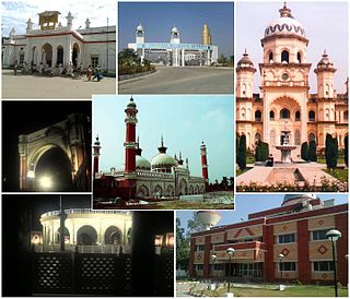
Bareilly is a city in Bareilly district in the Indian state of Uttar Pradesh. It is among the largest metropolises in Western Uttar Pradesh and is the centre of the Bareilly division as well as the historical region of Rohilkhand. The city lies in the Indo-Gangetic Plains, about 252 kilometres (157 mi) north west of the state capital, Lucknow, and 265 kilometres (165 mi) east of the national capital, New Delhi. With a population of 898,167 in 2011, it is the eighth most populous city in the state, seventeenth in northern India and fifty-fourth in India. It is located on the bank of Ramganga River and is the site of the Ramganga Barrage built for canal irrigation.

Rohillas are a mixed Indian community of Pashtun heritage, historically found in Rohilkhand, a region in the state of Uttar Pradesh, India. It forms the largest Pashtun diaspora community in India, and has given its name to the Rohilkhand region. The Rohilla military chiefs settled in this region of northern India in the 1720s, the first of whom was Ali Mohammed Khan.
Moradabad is a city, commissionary and municipal corporation in Moradabad district of the Indian state of Uttar Pradesh. Moradabad is situated on the banks of the Ramganga river, at a distance of 167 km (104 mi) from the national capital, New Delhi and 344 km north-west of the state capital, Lucknow.

The Bareilly districtpronunciation (help·info) belongs to the state Uttar Pradesh in northern India. Its capital is Bareilly city and it is divided in six administrative division or tehsils: Aonla, Baheri, Bareilly city, Faridpur, Mirganj, and Nawabganj. The Bareilly district is a part of the Bareilly Division and occupies an area of 4120 km2 with a population of 4,448,359 people according to the census of 2011.

Bangalore is the capital city of the state of Karnataka. Bangalore, as a city, was founded by Kempe Gowda I, who built a mud fort at the site in 1537. But the earliest evidence for the existence of a place called Bangalore dates back to c. 890.

Farrukhabad district is a district of Uttar Pradesh state in Northern India. The town of Fatehgarh is the district headquarters. The district is part of Kanpur Division.
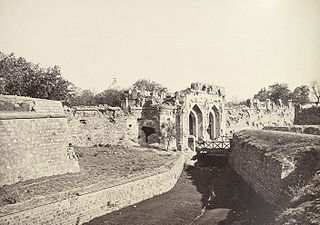
The siege of Delhi was one of the decisive conflicts of the Indian Rebellion of 1857.
The Civil Lines is a residential area and one of the 3 subdivisions of the Central Delhi district of Delhi in India. It is one of the 12 zones under the Municipal Corporation of Delhi. It was the hub of European-style hotels in the city until New Delhi came into being in 1911. The official residence of the Lieutenant Governor of Delhi is also located at Raj Niwas Marg, Civil Lines.

Rampur State was a 15 gun-salute princely state of British India. It came into existence on 7 October 1774 as a result of a treaty with Oudh. Following independence in 1947, Rampur State and other princely states of the area, such as Benares and Tehri Garhwal were merged into the United Provinces. Rampur state had its capital in Rampur city and its total area was 945 sq miles. Rampur state was founded by Ali Mohammad Khan's younger son Faizullah Khan.
According to the epic Mahābhārata, Bareilly region (Panchala) is said to be the birthplace of Draupadi, who was also referred to as 'Panchali' by Kṛṣṇā. When Yudhishthira becomes the king of Hastinapura at the end of the Mahābhārata, Draupadi becomes his queen. The folklore says that Gautama Buddha had once visited the ancient fortress city of Ahicchattra in Bareilly. The Jain Tirthankara Parshva is said to have attained Kaivalya at Ahichhatra.

Bareilly Airport is a domestic airport serving Bareilly, Uttar Pradesh, India at Indian Air Force's Trishul Air Base in Izzatnagar, located 6 kilometres (3.7 mi) north from the city centre.
Civil Lines are the residential neighbourhoods developed during the British Raj for its senior civilian officers like Divisional commissioner and District magistrate. These townships were built all over the Indian subcontinent and were allotted to civil officers in the respective countries. This is distinct from Forts and Cantonments, which were expressedly military establishments.
Oudh and Rohilkhand Railway was an extensive railway network in the North India, mostly north of the Ganges, starting from Benares and subsequently up to Delhi.

Aligarh Junction railway station is an 'A' class junction station on the Kanpur–Delhi section of Howrah–Delhi main line and Howrah–Gaya–Delhi line. It is located in Aligarh district in the Indian state of Uttar Pradesh. It serves Aligarh.
The Mall or Mall Road, also known as Mahatma Gandhi Road is a central business district of Indian city of Kanpur. The area houses many shopping complexes, hotels, MNCs and shopping stores. Mall Road is one of the busiest roads of the city, traffic is daily thrown out of gear here. The road houses the biggest mall of the city, Christ Church College built in 1866, Reserve Bank of India, GPO and many other prominent buildings.

Bareilly Cantonment is a cantonment town located in the Bareilly district of the north Indian state of Uttar Pradesh.

