
Urban renewal is a program of land redevelopment often used to address urban decay in cities. Urban renewal involves the clearing out of blighted areas in inner cities in favour of new housing, businesses, and other developments.

Regent Park is a neighbourhood located in downtown Toronto, Ontario built in the late 1940s as a public housing project managed by Toronto Community Housing. It sits on what used to be a significant part of the Cabbagetown neighbourhood and is bounded by Gerrard Street East to the north, River Street to the east, Shuter Street to the south and Parliament Street to the west. Regent Park's residential dwellings, prior to the ongoing redevelopment, were entirely social housing and covered all of the 69 acres (280,000 m2) which comprise the community. The original neighbourhood was razed in the process of creating Regent Park. The nickname Cabbagetown is now applied to the remaining historical, area north and west of the housing project, which has experienced considerable gentrification since the 1960s and 1970s.
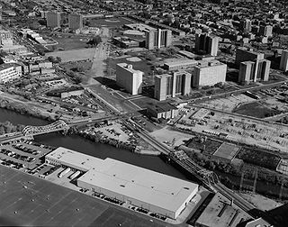
Cabrini–Green Homes are a Chicago Housing Authority (CHA) public housing project on the Near North Side of Chicago, Illinois. The Frances Cabrini Rowhouses and Extensions were south of Division Street, bordered by Larrabee Street to the west, Orleans Street to the east and Chicago Avenue to the south, with the William Green Homes to the northwest.

East Liberty is a neighborhood in Pittsburgh, Pennsylvania's East End. It is bordered by Highland Park, Morningside, Stanton Heights, Garfield, Friendship, Shadyside and Larimer, and falls largely within Pittsburgh City Council District 9, with a few areas in District 8. One of the most notable features in the East Liberty skyline is the East Liberty Presbyterian Church, which is an area landmark.

Downtown Louisville is the largest central business district in the Commonwealth of Kentucky and the urban hub of the Louisville, Kentucky Metropolitan Area. Its boundaries are the Ohio River to the north, Hancock Street to the east, York and Jacob Streets to the south, and 9th Street to the west. As of 2015, the population of downtown Louisville was 4,700, although this does not include directly surrounding areas such as Old Louisville, Butchertown, NuLu, and Phoenix Hill.
Irish Hill is a neighborhood east of downtown Louisville, Kentucky USA. It is bounded by Baxter Avenue to the west, Lexington Road to the north, the middle fork of Beargrass Creek and I-64 to the east. Cave Hill Cemetery is located directly south of Irish Hill. It is in the inner Highlands area of Louisville.
Smoketown is a neighborhood one mile (1.6 km) southeast of downtown Louisville, Kentucky. Smoketown has been a historically black neighborhood since the Civil War. It is the only neighborhood in the city that has had such a continuous presence. Smoketown is bounded by Broadway, CSX railroad tracks, Kentucky Street, and I-65.
HOPE VI is a program of the United States Department of Housing and Urban Development. It is intended to revitalize the most distressed public housing projects in the United States into mixed-income developments. Its philosophy is largely based on New Urbanism and the concept of defensible space.

Myrtle Avenue is a 8.1-mile-long (13.0 km) street that runs from Duffield Street in Downtown Brooklyn to Jamaica Avenue in Richmond Hill, Queens, in New York City, United States. Myrtle is a main thoroughfare through the neighborhoods of Fort Greene, Clinton Hill, Bedford-Stuyvesant, Bushwick, Ridgewood, and Glendale.
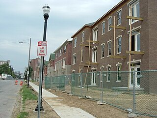
Park DuValle is a neighborhood southwest of downtown Louisville, Kentucky. It was developed starting in the late-19th century and historically been a predominantly African-American community. Its boundaries are I-264 to the west, the Norfolk Southern Railway tracks to the north, Cypress Street to the east, and Bells Lane and Algonquin Parkway to the south. The neighborhood reflects the presence of several nearby parks, and DuValle Junior High School; all named after Lucie DuValle, the first female principal of a high school in Louisville.
Phoenix Hill is a neighborhood of Louisville, Kentucky just east of Downtown. Its boundaries are Market Street to the North, Preston Street to the West, Broadway to the South, and Baxter Avenue to the East. The Phoenix Hill neighborhood, settled before 1850 by German immigrants, is now a rich tapestry of people and a diverse mix of business, industry and residences.

Liberty Square, often referred to as the Pork & Beans, is a 753-unit Miami-Dade public housing apartment complex in the Liberty City neighborhood of Miami, Florida. It is bordered at Martin Luther King Jr. Boulevard/North 62nd Street to the south, North 67th Street to the north, State Road 933 to the east, and Northwest 15th Avenue to the west. Constructed as a part of the New Deal by the Public Works Administration and opening in 1937, it was the first public housing project for African Americans in the Southern United States. It is featured in the 2023 documentary film, Razing Liberty Square.
Downtown Commons, formerly known as Sacramento Downtown Plaza, Westfield (Shoppingtown) Downtown Plaza and Downtown Plaza, is a two-level outdoor mixed-use entertainment and shopping complex operated by JMA Ventures, LLC, located along the alignment of K Street in downtown Sacramento, California, United States, near the State Capitol building. The complex is bordered by J Street to the north, L Street to the south, 7th Street to the east and 4th Street to the west. Downtown Commons' previous format was a mainly two-level outdoor shopping mall commonly known as Downtown Plaza, despite numerous official name changes over the years. The majority of the site has been redeveloped, centering on Golden 1 Center, home of the NBA's Sacramento Kings. The section between 5th and 7th Streets was demolished in 2014 to make room for Golden 1 Center, as well as The Sawyer, a 250-room boutique hotel operated by Kimpton Hotels immediately north of the arena site. The remaining standing section between 4th and 5th Streets was also redeveloped a few years later in association with the arena project.

The urban development patterns of Lexington, Kentucky, confined within an urban growth boundary protecting its famed horse farms, include greenbelts and expanses of land between it and the surrounding towns. This has been done to preserve the region's horse farms and the unique Bluegrass landscape, which bring millions of dollars to the city through the horse industry and tourism. Urban growth is also tightly restricted in the adjacent counties, with the exception of Jessamine County, with development only allowed inside existing city limits. In order to prevent rural subdivisions and large homes on expansive lots from consuming the Bluegrass landscape, Fayette and all surrounding counties have minimum lot size requirements, which range from 10 acres (40,000 m2) in Jessamine to fifty in Fayette.
Louisville, Kentucky is home to numerous structures that are noteworthy due to their architectural characteristics or historic associations, the most noteworthy being the Old Louisville neighborhood, the third largest historic preservation district in the United States. The city also boasts the postmodern Humana Building and an expanding Waterfront Park which has served to remove the former industrial appearance of the riverfront.

Capitol View is a historic intown southwest Atlanta, Georgia neighborhood. The neighborhood is 2.5 miles from downtown and was named for its views of the Georgia State Capitol building. Its boundaries include Metropolitan Parkway to the east, Lee Street to the west, and the Beltline to the north. On the south, the border follows Arden Street, Deckner Avenue, and Perkerson Park.

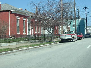
The East Market District, colloquially referred to as NuLu, is an unofficial district of Louisville, Kentucky, situated along Market Street between downtown to the west, Butchertown to the north, Phoenix Hill to the south, and Irish Hill to the east. The area is home to schools, churches, large and small businesses and some of the city's oldest homes and businesses. A destination since Louisville's founding, Market Street has played host to a variety of businesses throughout the city's history that have drawn Louisvillians for generations to its addresses.
In 1994 the Atlanta Housing Authority, encouraged by the federal HOPE VI program, embarked on a policy created for the purpose of comprehensive revitalization of severely distressed public housing developments. These distressed public housing properties were replaced by mixed-income communities.

Redlands Mall was a small shopping mall in Redlands, California, with two anchors, CVS Pharmacy and Gottschalks. The mall, located on about 12 acres on Orange Street and Eureka Street between Redlands Boulevard and Citrus Avenue, was built in 1977. The mall permanently closed in 2010.