Clear Creek Trail (Washington)

Last updated
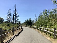
A paved section of Clear Creek Trail near the Silverdale Dog Park trailhead, with a bridge over Clear Creek visible in the background ClearCreekTrail.jpg
A paved section of Clear Creek Trail near the Silverdale Dog Park trailhead, with a bridge over Clear Creek visible in the background

Clear Creek Trail is an urban trail in Silverdale, Washington, "at once in the suburbs and simultaneously immersed in the natural world". [1] In a 2011 book by Mountaineers Books, it was reported to be over seven miles long. [2] The trail extends along Clear Creek from its uplands near the Naval Base Kitsap-Bangor Trigger Avenue gate on State Route 3 to the creek's estuary at Dyes Inlet. [3]

Contents

History of trail creation

The trail was created around 1994 by Kitsap Land Trust and Clear Creek Task Force. [4] In 1997, it was being cleared by volunteers and was two miles long. [5] The trail system was six miles long as of 2011. [3]

In 2011, a guerrilla art project appeared in the trail system: a lifelike giraffe near the trail. [6]

Awards

The trail was selected by Evening Magazine television viewers in 2007 as the "Best hidden Hiking Trail" in Western Washington. [7]

Related Research Articles

<span class="mw-page-title-main">Kitsap County, Washington</span> County in Washington, United States

Kitsap County is located in the U.S. state of Washington. As of the 2020 census, its population was 275,611. Its county seat is Port Orchard; its largest city is Bremerton. The county, formed out of King County and Jefferson County on January 16, 1857, is named for Chief Kitsap of the Suquamish Tribe. Originally named Slaughter County, it was soon renamed.

<span class="mw-page-title-main">Bremerton, Washington</span> City in Washington, United States

Bremerton is a city in Kitsap County, Washington. The population was 43,505 at the 2020 census and an estimated 44,122 in 2021, making it the largest city on the Kitsap Peninsula. Bremerton is home to Puget Sound Naval Shipyard and the Bremerton Annex of Naval Base Kitsap.

<span class="mw-page-title-main">Kingston, Washington</span> Census-designated place in Washington, United States

Kingston is an unincorporated community and census-designated place (CDP) in Kitsap County, Washington, United States. The population was 2,515 at the 2020 census. Kingston is along the shores of Appletree Cove and Puget Sound, and is home to a major Washington State Ferry terminal linking it to Edmonds.

<span class="mw-page-title-main">Port Orchard, Washington</span> City in Washington, United States

Port Orchard is a city in and the county seat of Kitsap County, Washington, United States. It is located 13 miles (21 km) due west of West Seattle and is connected to Seattle and Vashon Island via the Washington State Ferries run to Southworth. It is named after Port Orchard, the strait that separates Bainbridge Island from the Kitsap Peninsula.

<span class="mw-page-title-main">Poulsbo, Washington</span> City in Washington, United States

Poulsbo is a city on Liberty Bay in Kitsap County, Washington, United States. It is the smallest of the four cities in Kitsap County. The population was 11,970 at the 2020 census and an estimated 10,927 in 2018.

<span class="mw-page-title-main">Silverdale, Washington</span> Place in Washington, United States

Silverdale is an unincorporated community in Kitsap County, Washington, in the United States. Despite many failed attempts at incorporation, Silverdale has not become a city. The population was 20,733 at the 2020 census. For statistical purposes, the United States Census Bureau has defined Silverdale as a census-designated place (CDP).

<span class="mw-page-title-main">Washington State Route 3</span> State highway in the U.S. state of Washington

State Route 3 (SR 3) is a 59.81-mile-long (96.25 km) state highway in the U.S. state of Washington, serving the Kitsap Peninsula in Mason and Kitsap counties. The highway begins at U.S. Route 101 (US 101) south of Shelton and travels northeast onto the Kitsap Peninsula through Belfair to Gorst, where it intersects SR 16 and begins its freeway. SR 3 travels west of Bremerton, Silverdale and Poulsbo before it terminates at the eastern end of the Hood Canal Bridge, signed as SR 104. The highway is designated as a Strategic Highway Network (STRAHNET) corridor under the National Highway System as the main thoroughfare connecting both parts of Naval Base Kitsap and is also part of the Highways of Statewide Significance program.

<span class="mw-page-title-main">Dyes Inlet</span>

Dyes Inlet is an inlet on the Kitsap Peninsula in western Washington, USA. The unincorporated Silverdale community is located on the north shore of the inlet and has a small marina, boat ramp, boardwalk, and two waterfront parks. The west shoreline rests on Chico, and the east shoreline is Tracyton, both census-designated places. Dyes Inlet is connected to the strait of Port Orchard via the Port Washington Narrows, Port Washington being an earlier name for the inlet. It was named for John W. W. Dyes, a taxidermist with the Wilkes Expedition of 1841. Chico Creek and Clear Creek are the major fresh waterways that drain into the inlet. Both creeks have heavy salmon runs during the fall.

Olympic College is a public community college in Bremerton, Washington. It opened as Olympic Junior College on September 5, 1946. Olympic College serves Kitsap and Mason counties in Washington. The college's service area contains two major naval installations: Naval Base Kitsap and Naval Hospital Bremerton.

<span class="mw-page-title-main">Kitsap Regional Library</span> Library system in Kitsap County, Washington

The Kitsap Regional Library is a public library system in Kitsap County, Washington, United States. It has nine locations that serve over 280,000 residents in Kitsap County; its collection includes over 300,000 items that have an annual circulation of 2.4 million. Founded in 1945 as the Kitsap County Rural Library District, the modern system was formed from a 1955 merger with the Bremerton city library.

<span class="mw-page-title-main">Bangor Base, Washington</span> Census-designated place in Washington, United States

Bangor Base is a census-designated place (CDP) in Kitsap County, Washington, within U.S. Naval Base Kitsap on the Kitsap Peninsula. Its population was 5,482 at the 2020 census.

<span class="mw-page-title-main">Washington State Route 303</span> Highway in Kitsap County, Washington

State Route 303 (SR 303) is a 9.27-mile (14.92 km) state highway in Kitsap County, located in the U.S. state of Washington. The highway connects SR 304 in Bremerton to an interchange with SR 3 in Silverdale. SR 303 crosses the Port Washington Narrows on the Warren Avenue Bridge in Bremerton and becomes a grade-separated freeway bypass of Silverdale. The route has existed as unpaved roads since the 1930s and was signed as Secondary State Highway 21B (SSH 21B) in 1937. SSH 21B connected Bremerton to Keyport and had a branch to Illahee State Park added in 1961. After the 1964 highway renumbering, SSH 21B became SR 303 from Bremerton to Keyport and SR 306 from Bremerton to Illahee State Park. SR 303 was shortened in 1971, to include SR 308, and in 1991, re-routing the highway onto the new Silverdale freeway. SR 303 also had a spur route in Bremerton that served the Manette Bridge until 1991.

<span class="mw-page-title-main">Washington State Route 310</span> Highway in Washington

State Route 310 (SR 310) is a 1.84-mile-long (2.96 km) state highway in the U.S. state of Washington, serving the city of Bremerton in Kitsap County. The highway travels east within Bremerton from an interchange with SR 3 to an intersection with SR 304 as Kitsap Way and Callow Avenue. SR 310 was established in 1991, following the former alignment of SR 3 on city streets in Bremerton before the construction of its current freeway in the 1960s and 1970s. The highway was codified in 1915 as State Road 21 in 1915 and Primary State Highway 21 (PSH 21) in 1937 before becoming SR 3 during the 1964 highway renumbering.

Central Kitsap School District 401 is a public school district in Kitsap County, Washington, United States. It serves unincorporated portions of the county, including the community of Silverdale, and portions of the City of Bremerton. As of June 2014, the district has an enrollment of 11,091 students. Approximately one-quarter of students are from military families, and one half are from families economically dependent on the US Navy. It consists of CK High and Middle school, Klahowya, and other schools like Ridgetop or Fairview

<span class="mw-page-title-main">Kitsap Admirals</span> Basketball team in Bremerton, Washington

The Kitsap Admiral Basketball Club is a semi-professional international feeder program that is based in Bremerton, Washington. It was established in 2011 by former semi-pro basketball player Ashley D. Robinson.

<span class="mw-page-title-main">Green Mountain (Kitsap County, Washington)</span> Mountain in Washington (state), United States

Green Mountain is a 1,700-foot (520 m) summit in the Blue Hills on the Kitsap Peninsula of Washington state, in the United States' Pacific Northwest. It is the second highest point on the Kitsap Peninsula and in Kitsap County, Washington, after 1,761-foot (537 m) Gold Mountain.

The Blue Hills just west of Bremerton, Washington, also called the Bremerton Hills, Bald Hills, and Wildcat Hills, consist of Gold Mountain, Green Mountain, and several informally named hills. Reaching an elevation of 1761 feet, a thousand feet above the glacial till that fills the Puget Lowland, they form a prominent landmark visible around the region. They are formed of uplifted blocks of marine basalts, the steep-walled canyons between the various summits being the fissures between the blocks. In addition to Gold Mountain and Green Mountain are several other prominent peaks unofficially named according to their elevation :

<span class="mw-page-title-main">Satsop Hills</span>

The Satsop Hills are foothills of the Olympic Mountains in Mason County, Washington north of Matlock, Washington, between Wynoochee Lake to the west and Lake Cushman to the east.

Pritchard Park is a 50-acre (20 ha) former Superfund environmental cleanup site on the shore of Bainbridge Island's Eagle Harbor in Washington state.

Port Gamble Forest Heritage Park is a 3,493-acre (1,414 ha) county park founded in 2014, and is the largest in Kitsap County, Washington. It contains 60 miles (97 km) of trails.

References

  1. "A Wet Day in the Wetlands at Silverdale's Clear Creek Trail".
  2. Romano 2016, p. 77.
  3. 1 2 Okinaka, Kristin (October 28, 2011). "Making the connection north — Clear Creek Task Force continues discussions to extend trail despite hurdles". Kitsap Daily News. Poulsbo, Washington.
  4. Andersson, Martha (November 21, 1994). "Clear Creek Trail". Kitsap Sun . Bremerton, Washington.
  5. Dunagan, Christopher (May 13, 1997), "Trailblazers march on", Kitsap Sun
  6. "Clear Creek Trail: The Next African Safari? | Peninsular Thinking".
  7. Boyle, Jean (October 3, 2007). "Clear Creek Trial in Silverdale – "Best hidden Hiking Trail"". Kitsap and Beyond (blog). Seattle Post-Intelligencer.

Sources

47°39′04″N122°41′06″W / 47.651°N 122.685°W / 47.651; -122.685