Clear Creek Trail (Washington)

Last updated

A paved section of Clear Creek Trail near the Silverdale Dog Park trailhead, with a bridge over Clear Creek visible in the background ClearCreekTrail.jpg
A paved section of Clear Creek Trail near the Silverdale Dog Park trailhead, with a bridge over Clear Creek visible in the background

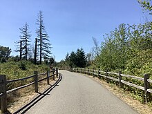
Clear Creek Trail is an urban trail in Silverdale, Washington, "at once in the suburbs and simultaneously immersed in the natural world". [1] In a 2011 book by Mountaineers Books, it was reported to be over seven miles long. [2] The trail extends along Clear Creek from its uplands near the Naval Base Kitsap-Bangor Trigger Avenue gate on State Route 3 to the creek's estuary at Dyes Inlet. [3]

Contents

History of trail creation

The trail was created around 1994 by Kitsap Land Trust and Clear Creek Task Force. [4] In 1997, it was being cleared by volunteers and was two miles long. [5] The trail system was six miles long as of 2011. [3]

In 2011, a guerrilla art project appeared in the trail system: a lifelike giraffe near the trail. [6]

Awards

The trail was selected by Evening Magazine television viewers in 2007 as the "Best hidden Hiking Trail" in Western Washington. [7]

References

  1. "A Wet Day in the Wetlands at Silverdale's Clear Creek Trail".
  2. Romano 2016, p. 77.
  3. 1 2 Okinaka, Kristin (October 28, 2011). "Making the connection north — Clear Creek Task Force continues discussions to extend trail despite hurdles". Kitsap Daily News. Poulsbo, Washington.
  4. Andersson, Martha (November 21, 1994). "Clear Creek Trail". Kitsap Sun . Bremerton, Washington.
  5. Dunagan, Christopher (May 13, 1997), "Trailblazers march on", Kitsap Sun
  6. "Clear Creek Trail: The Next African Safari? | Peninsular Thinking".
  7. Boyle, Jean (October 3, 2007). "Clear Creek Trial in Silverdale – "Best hidden Hiking Trail"". Kitsap and Beyond (blog). Seattle Post-Intelligencer.

Sources

47°39′04″N122°41′06″W / 47.651°N 122.685°W / 47.651; -122.685