
The Clackamas River is an approximately 83-mile (134 km) tributary of the Willamette River in northwestern Oregon, in the United States. Draining an area of about 940 square miles (2,435 km2), the Clackamas flows through mostly forested and rugged mountainous terrain in its upper reaches, and passes agricultural and urban areas in its lower third. The river rises in eastern Marion County, about 55 miles (89 km) east-southeast of Salem. The headwaters are on the slopes of Olallie Butte in the Mount Hood National Forest, about 10 miles (16 km) north of Mount Jefferson, at an elevation of 4,909 feet (1,496 m) in the Cascade Range. The Clackamas flows briefly north and then flows northwest through the mountains, passing through North Fork Reservoir and Estacada. It then emerges from the mountains southeast of Portland. It joins the Willamette near Oregon City and forms the boundary between Oregon City and Gladstone.

The John Day River is a tributary of the Columbia River, approximately 284 miles (457 km) long, in northeastern Oregon in the United States. It is known as the Mah-Hah River by the Cayuse people. Undammed along its entire length, the river is the fourth longest free-flowing river in the contiguous United States. There is extensive use of its waters for irrigation. Its course furnishes habitat for diverse species, including wild steelhead and Chinook salmon runs. However, the steelhead populations are under federal Endangered Species Act (ESA) protections, and the Chinook salmon have been proposed for such protection.

The Owyhee River is a tributary of the Snake River located in northern Nevada, southwestern Idaho and southeastern Oregon in the Western United States and its Pacific Northwest region. It is 280 miles (450 km) long. The river's drainage basin is 11,049 square miles (28,620 km2) in area, one of the largest subbasins of the Columbia River Basin with its major waterways of the Columbia River and Snake River. The mean annual discharge is 995 cubic feet per second (28.2 m3/s), with a maximum of 50,000 cu ft/s (1,400 m3/s) recorded in 1993 and a minimum of 42 cu ft/s (1.2 m3/s) in 1954.

The Coast Fork Willamette River is one of two forks that unite to form the Willamette River in western Oregon in the United States. It is about 40 miles (64 km) long, draining an area of the mountains at the south end of the Willamette Valley south of Eugene.

The Kilchis River is a stream, about 14 miles (23 km) long, near the coast of northwest Oregon in the United States. It drains a mountainous timbered region of about 65 square miles (170 km2) in the Northern Oregon Coast Range west of Portland.
Clear Creek may refer to:
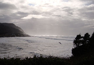
The Yachats River is a short river on the central Oregon coast, about 60 miles (100 km) west-north-west of Eugene. The name is the native name meaning at the foot of the mountain.
Clear Fork is the name of various locations in the United States:

The Wallowa–Whitman National Forest is a United States National Forest in the U.S. states of Oregon and Idaho. Formed upon the merger of the Wallowa and Whitman national forests in 1954, it is located in the northeastern corner of Oregon, in Wallowa, Baker, Union, Grant, and Umatilla counties, and includes small areas in Nez Perce and Idaho counties in Idaho. The forest is named for the Wallowa band of the Nez Perce people, who originally lived in the area, and Marcus and Narcissa Whitman, Presbyterian missionaries who settled just to the north in 1836. Forest headquarters are located in Baker City, Oregon with ranger districts in La Grande, Joseph and Baker City.

The Umatilla National Forest, in the Blue Mountains of northeast Oregon and southeast Washington, covers an area of 1.4 million acres (5,700 km2). In descending order of land area the forest is located in parts of Umatilla, Grant, Columbia, Morrow, Wallowa, Union, Garfield, Asotin, Wheeler, and Walla Walla counties. More than three-quarters of the forest lies in the state of Oregon. Forest headquarters are located in Pendleton, Oregon. There are local ranger district offices in Heppner and Ukiah in Oregon, and in Pomeroy and Walla Walla in Washington.

The Middle Fork Willamette River is one of several forks that unite to form the Willamette River in the western part of the U.S. state of Oregon. It is approximately 115 miles (185 km) long, draining an area of the Cascade Range southeast of Eugene, which is at the southern end of the Willamette Valley.
Illinois River Forks State Park is a state park in the U.S. state of Oregon, administered by the Oregon Parks and Recreation Department. The park consists of approximately 400 acres, with 170 located between the forks of the Illinois River and the remainder on the west side. The portion between the forks of the river and accessed from Highway 199 just south of Cave Junction, is developed with paved parking, grass lawns with picnic tables, outhouses, and offers a wonderful swimming hole for summer users. The west side of the park, accessed from Westside Road, offers the West Side Trailhead and nearly seven miles of single-track, natural surface hiking and equestrian trails. There is gravelled parking for cars, and a separate pull-through parking lane area for horse rigs. A vault toilet and kiosk with the trail system displayed is in the parking area.

The Copper Salmon Wilderness is a protected wilderness area in the Southern Oregon Coast Range and is part of the Rogue River–Siskiyou National Forest. The wilderness area was created by the Omnibus Public Land Management Act of 2009, which was signed into law by President Barack Obama on March 30, 2009.

Little Butte Creek is a 17-mile-long (27 km) tributary of the Rogue River in the U.S. state of Oregon. Its drainage basin consists of approximately 354 square miles (917 km2) of Jackson County and another 19 square miles (49 km2) of Klamath County. Its two forks, the North Fork and the South Fork, both begin high in the Cascade Range near Mount McLoughlin and Brown Mountain. They both flow generally west until they meet near Lake Creek. The main stem continues west, flowing through the communities of Brownsboro, Eagle Point, and White City, before finally emptying into the Rogue River about 3 miles (5 km) southwest of Eagle Point.

Big Butte Creek is a 12-mile-long (19 km) tributary of the Rogue River in the U.S. state of Oregon. It drains approximately 245 square miles (635 km2) of Jackson County. Its two forks, the North Fork and the South Fork, both begin high in the Cascade Range near Mount McLoughlin. Flowing predominantly west, they meet near the city of Butte Falls. The main stem flows generally northwest until it empties into the Rogue Falls was incorporated in 1911, and remains the only incorporated town within the watershed's boundaries.

The South Fork Clackamas River is a tributary, roughly 8 miles (13 km) long, of the Clackamas River in the U.S. state of Oregon. Beginning near South Fork Mountain in the western Cascade Range, the river flows generally north through Clackamas County to meet the larger river at Big Cliff. Most of the South Fork's drainage basin lies within the Mount Hood National Forest.
The South Fork Coquille River is the longest tributary of the Coquille River in coastal Oregon in the United States. From its headwaters in the Southern Oregon Coast Range, the river flows northwest to join the North Fork Coquille River at Myrtle Point, forming the main stem Coquille. The South Fork is about 63 miles (101 km) long, and its watershed drains roughly 288 square miles (750 km2) of rural Coos County.
The North Fork Owyhee River is a tributary, about 30 miles (48 km) long, of the Owyhee River in Malheur County, Oregon, and Owyhee County, Idaho, in the United States. It begins on the east flank of the Owyhee Mountains in Idaho and flows generally southwest to meet the main stem at Three Forks, Oregon, 161 miles (259 km) above the confluence of the larger river with the Snake River.
